
Kathmandu, officially Kathmandu Metropolitan City, is the capital and most populous city of Nepal with 845,767 inhabitants living in 105,649 households as of the 2021 Nepal census and approximately 4 million people in its urban agglomeration. It is located in the Kathmandu Valley, a large valley in the high plateaus in central Nepal, at an altitude of 1,400 metres.

Kirtipur is a Municipality and an ancient city of Nepal. The Newars are the natives of Kipoo (Kirtipur). It is located in the Kathmandu Valley 5 km south-west of the city of Kathmandu. It is one of the five dense municipalities in the valley, the others being Kathmandu, Lalitpur, Bhaktapur and Madhyapur Thimi. It is one of the most famous and religious places to visit. Many people visit this place not only for its natural environment but also to visit temples. The city was listed as a UNESCO tentative site in 2008.

The Kathmandu Valley, also known as the Nepal Valley or Nepa Valley, National Capital Area, is a bowl-shaped valley located in the Himalayan mountains of Nepal. It lies at the crossroads of ancient civilizations of the Indian subcontinent and the broader Asian continent, and has at least 130 important monuments, including several pilgrimage sites for Hindus and Buddhists. There are seven World Heritage Sites within the valley.
Shechen Monastery is one of the "Six Mother Monasteries" of the Nyingma tradition of Tibetan Buddhism. It was originally located in Kham, Tibet, but was destroyed in the late 1950s during the Cultural Revolution and was rebuilt in Nepal in 1985.

Kathmandu District is a district located in Kathmandu Valley, Bagmati Province of Nepal. It is one of the 77 districts of Nepal, covers an area of 413.69 km2 (159.73 sq mi), and is the most densely populated district of Nepal with 1,081,845 inhabitants in 2001, 1,744,240 in 2011 and 2,017,532 in 2021. The administrative headquarters of Kathmandu district is located in Kathmandu. The city has 21 post offices which handle mail from across the country and beyond, with Kathmandu DPO having 44,600 as its postal code for international mail delivery services like UPS or DHL Couriers etc.

Pyuthan District (Nepali: प्युठान जिल्ला, is a "hill" district some 427.6 km west of Kathmandu in Lumbini Province in midwestern Nepal. Pyuthan covers an area of 1,309 km2 with population of 212,484 in 2001 and 226,796 in 2011. Pyuthan Khalanga is the district's administrative center.
Bharatpur is a city in south central Nepal. It is the third most populous city of Nepal after Kathmandu and Pokhara with 369,377 inhabitants in 2021. It is also the second largest metropolitan city in Nepal by area. It is the district headquarter of the Chitwan District.

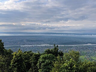
Nagarkot is a former Village Development Committee located 32 km east of Kathmandu, Nepal in Bhaktapur District in Bagmati Province and as of 2015 part of Nagarkot Municipality. At the time of the 2011 census it had a population of 4,571 and had 973 houses in it. At an elevation of 2,195 meters, it is considered one of the most scenic spots in Bhaktapur District. It is known for a sunrise view of the Himalayas including Mount Everest as well as other peaks of the Himalayan range of eastern Nepal. Nagarkot also offers views of the Kathmandu Valley. The scenery of the place makes it a popular hiking route for tourists. It is located approximately 7000 ft above sea level and 28 km from Kathmandu International Airport.

Janakpurdham or Janakpur is a sub-metropolitan city in Dhanusha district, Madhesh Province, Nepal. The city is a hub for religious and cultural tourism. A headquarter of Dhanusha district, Janakpur is also the capital for Madhesh Province.

Chhaling is a village and former Village Development Committee that is now part (Ward-5) of Changunarayan Municipality in Province No. 3 of central Nepal. At the time of the 2011 Nepal census it had a population of 8,129 with 1,817 houses in it. It is situated at about a distance of 20 kilometers from the capital city of Kathmandu.
Bajrayogini is a village and former Village Development Committee that is now part of Shankharapur Municipality in Kathmandu District in Province No. 3 of central Nepal. At the time of the 1991 Nepal census it had a population of 3,798 and had 632 houses in it. As per 2011 Nepal census it had a population of 4,333 and had 328 houses in it.
Baluwa is a village and former Village Development Committee that is now part of Gokarneshwar Municipality in Kathmandu District in Bagmati Province of central Nepal. At the time of the 2011 Nepal census it had a population of 5,467 and had 1,204 houses in it. It is located at north-east side from the capital city of Nepal. It touch Nuwakot District to the north and Gorkna VDC to the south. In east side, there is Nayapati VDC and in west Kapan VDC.

Bhadrabas is a village and former Village Development Committee that is now part of Kageshwari-Manohara Municipality in Kathmandu District in Province No. 3 of central Nepal, located approximately 15 kilometres (9 mi) northeast of Kathmandu. At the time of the 2011 Nepal census it had a population of 2,388 and had 503 houses in it. The oldest high school in the eastern Kathmandu Valley, Adarsh Madhayamik Vidhalaya is located in Bhadrabas. The Nepal Red Cross Society is active in Bhadrabas and it has notable health centre. In 1984, a tobacco smoking World Health Organization questionnaire was given to the inhabitants of Bhadrabas to survey smoking trends in the country.

Budhanilkantha is a city and municipality in Kathmandu district of Bagmati province of Nepal. It is the 3rd largest city in the Kathmandu Valley after Kathmandu and Lalitpur. As per 2021 Nepal census, the city population was 179,688 and 26,678 households.
Gongabu is a village and former Village Development Committee that is now part of Tokha Municipality in Kathmandu District in Province No. 3 of central Nepal. At the time of the 2011 Nepal census it had a population of 54,410 and had 14,456 households in it in an area just 270 hectares in size
Gothatar is a village and former Village Development Committee that is now part of Kageshwari-Manohara Municipality in Kathmandu District in Province No. 3 of central Nepal. It being handled By ward Secretary name Prapta Luital. At the time of the 2011 Nepal census it had a population of 26,169 and had 6,749 households in it. The newly built Bagmati bridge connects Gothatar with the roadway to Jorpati. The Krishna Parnami Mandir is one of the major attractions in Gothatar. In between 2007 and 2010, the density of population has rapidly increased as more and more houses are being constructed. The majority of the population in Gothatar consists of Hindu Brahmins and Kshetris. The natives are mainly farmers who still have cowsheds in their homes despite being very close to the rush of the metropolitan Kathmandu.
Indrayani is a village and former Village Development Committee that is now part of Shankharapur Municipality in Kathmandu District in Province No. 3 of central Nepal. At the time of the 1991 Nepal census it had a population of 2,635 and had 467 households in it. As per 2011 Nepal census it had a population of 3,361 and had 717 households in it.
Khadka Bhadrakali was a village in Kathmandu District in the Bagmati Zone before being incorporated into city of Budhanilkantha. At the time of the 1991 Nepal census it had a population of 5,539. On recent survey in 2011, the VDC had a total population of 10,761.

Rebati Ramanananda Shrestha (1932–2002) was a Nepalese freedom fighter, journalist and Nepal Bhasa author. He also wrote under the pen name R. R. N. Syasya. His works range from poems and epics to essays and short stories. He has written books on history, language, culture and religion.

