Dakshinkali

Last updated
Dakshinkali Municipality
दक्षिणकाली नगरपालिका
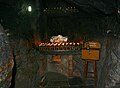
2009-03 Dakshinkali 02.jpg
Dakshinkali in 2009
Nepal Bagmati adm location map.svg
Red pog.svg
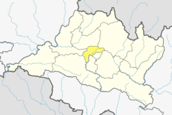
Dakshinkali Municipality
Location in Nepal
Nepal adm location map.svg
Red pog.svg
Dakshinkali Municipality
Dakshinkali Municipality (Nepal)
Coordinates: 27°35′0″N85°15′0″E / 27.58333°N 85.25000°E / 27.58333; 85.25000
CountryFlag of Nepal.svg    Nepal
Province Bagmati Province
District Kathmandu District
EstablishedDecember 2014
Government
   Mayor Mohan Basnet (NC)
   Deputy Mayor Basanti Tamang (Dangol) (NC)
Area
  Total42.6 km2 (16.4 sq mi)
Population
  Total26,372
  Density620/km2 (1,600/sq mi)
  Ethnicities
Newar Bahun Chhetri Tamang Magar
Time zone UTC+5:45 (NST)
Website www.daxinkalimun.gov.np/en

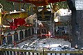
Dakshinkali is a municipality in Kathmandu District in the Province No. 3 of Nepal that was established on 2 December 2014 by merging the former Village development committees Chalnakhel, Chhaimale, Sheshnarayan, Sokhel, Talku Dudechaur and Old-Dakshinkali. [1] [2] The municipality's name means 'Southern Kali' and refers to a several centuries old temple complex that lies in the vicinity.

Contents

Population

Dakshinkali municipality has a total population of 24,297 according to 2011 Nepal census. [3] The population grew to 26,372 at the 2021 Nepal census. Around 99.3% of the residents are Nepali citizens and 80% are literate. [4]


See also

Related Research Articles

<span class="mw-page-title-main">Kathmandu Valley</span> Valley and proposed territory in Nepal

The Kathmandu Valley, also known as the Nepal Valley or Nepa Valley, National Capital Area, is a bowl-shaped valley located in the Himalayan mountains of Nepal. It lies at the crossroads of ancient civilizations of the Indian subcontinent and the broader Asian continent, and has at least 130 important monuments, including several pilgrimage sites for Hindus and Buddhists. There are seven World Heritage Sites within the valley.

<span class="mw-page-title-main">Gorkha District</span> District in Gandaki Province, Nepal

Gorkha District, a part of Gandaki Province, is one of 77 districts of Nepal, and the fourth largest district of the country in terms of area. It is historically linked with the creation of modern Nepal and the name of the legendary Gorkha soldiers. The district, with Gorkha Municipality as its district headquarters, covers an area of 3,610 km2 (1,390 sq mi) and has a population of 252,201, according to the 2021 Nepal census. Gorkha district is the site of the Manakamana Temple, as well as Gorakh Nath and Gorakh Kali temples. Several major rivers—including the Chepe, Daraudi, Marsyangdi, Budi Gandaki, and Trishuli—run through the district.

<span class="mw-page-title-main">Kathmandu District</span> District in Bagmati Province, Nepal

Kathmandu District is a district located in Kathmandu Valley, Bagmati Province of Nepal. It is one of the 77 districts of Nepal, covers an area of 413.69 km2 (159.73 sq mi), and is the most densely populated district of Nepal with 1,081,845 inhabitants in 2001, 1,744,240 in 2011 and 2,017,532 in 2021. The administrative headquarters of Kathmandu district is located in Kathmandu. The city has 21 post offices which handle mail from across the country and beyond, with Kathmandu DPO having 44,600 as its postal code for international mail delivery services like UPS or DHL Couriers etc.

Patan is a municipality in Baitadi District in the Mahakali Zone in Sudurpaschim Province of Far-western Nepal. The new municipality was formed by merging six existing villages Sakar, Silanga, Bhumeswor Gujar Basantapur and Patan on 2 December 2014. The office of the municipality is that of the former Patan village development committee. There are 10 wards in Patan

<span class="mw-page-title-main">Changunarayan</span> Municipality in Bagmati Province, Nepal

Changunarayan is a municipality in Bhaktapur District in the Province No. 3 of Nepal and is part of the urban agglomeration of the Kathmandu Valley. The municipality was created through the merger of the former Village development committees Old-Changunarayan, Chhaling, Duwakot and Jhaukhel in 2014. At the time of the 2011 Nepal census, the predecessors of Changunarayan Municipality had a population of 55,430. In 2017, the municipality of Mahamanjushree Nagarkot was merged into Changunarayan. The municipality is also home to the UNESCO World Heritage Site Changu Narayan.

<span class="mw-page-title-main">Budhanilkantha</span> Municipality in Bagmati Province, Nepal

Budhanilkantha is a city and municipality in Kathmandu district of Bagmati province of Nepal. It is the 3rd largest city in the Kathmandu Valley after Kathmandu and Lalitpur. As per 2021 Nepal census, the city population was 179,688 and 26,678 households.

<span class="mw-page-title-main">Chalnakhel</span> Village of Dakshinkali Municipality in No. 3, Nepal

Chalnakhel is a village and former Village Development Committee that is now part of Dakshinkali Municipality in Kathmandu District in Province No. 3 of central Nepal. At the time of the 2011 Nepal census it had a population of 4,365 living in 1,005 households.

<span class="mw-page-title-main">Chhaimale</span> Village of Dakshinkali Municipality in No. 3, Nepal

Chhaimale is a village and former Village Development Committee that is now part of Dakshinkali Municipality in Kathmandu District in Province No. 3 of central Nepal. At the time of the 2011 Nepal census it had a population of 4,216 living in 968 households.

Talku Dudechaur is a village and former Village Development Committee that is now part of Dakshinkali Municipality in Kathmandu District in Province No. 3 of central Nepal. At the time of the 2011 Nepal census it had a population of 2,858 and had 648 households in it.

Mithila is a municipality in Danusha District in Madhesh Province of south-eastern Nepal. After the government announcement the municipality was established on 2 December 2014 by merging the existing Begadawar, Nakatajhijh and Dhalkebar village development committees (VDCs). At the time of the 2011 Nepal census after merging the three VDCs population it had a total population of 31,575 persons. After the government decision the number of municipalities has reached 191 in Nepal.

Deumai is a municipality in the eastern development region of Ilam District in the Mechi Zone of Nepal. The new municipality was formed by merging two existing villages Mangalbare and Dhuseni on 02 Dec 2014. The office of the municipality is that of the former Mangalbare village development committee.

<span class="mw-page-title-main">Gokarneshwor</span> Municipality in Kathmandu District, Nepal

Gokarneshwor is a municipality in Kathmandu District in the Bagmati Province of Nepal that was established on 2 December 2014 by merging the former Village development committees Sundarijal, Nayapati, Baluwa, Jorpati and Gokarna. The office of the municipality is that of the former Jorpati village development committee. The river Bagmati has its origin as the name Bagh Dwar situated in the middle of the Shivapuri jungle in this municipality.

<span class="mw-page-title-main">Chandragiri Municipality</span> Municipality in Central, Nepal

Chandragiri is a municipality in Kathmandu District in Bagmati Province of Nepal that was declared as municipality on 2 December 2014 by merging the former Village Development Committees Baad Bhanjyang, Balambu, Dahachok, Mahadevsthan, Machhegaun, Matatirtha, Naikap Naya Bhanjyang, Naikap Purano Bhanjyang, Satungal, Thankot and Tinthana. The urban administration is located in Old-Balambu. The city's main attractions include Chandragiri Hill, Nepal with its Cable Car.

<span class="mw-page-title-main">Kageshwari-Manohara</span> Municipality in Bagmati Province, Nepal

Kageshwori-Manohara is a municipality in Kathmandu District in the Bagmati Province of Nepal that was established on 2 December 2014 by merging the former Village development committees of Aalapot, Bhadrabas, Danchhi, Gagalphedi, Gothatar and Mulpani. The office of the municipality is in Thali Danchhi in Ward No. 5.

<span class="mw-page-title-main">Tokha</span> Municipality in Bagmati Province, Nepal

Tokha is a municipality in Kathmandu District in Bagmati Province of Nepal that was established on 2 December 2014 by merging the former Village development committees Dhapasi, Jhor Mahankal, Gongabu, Tokha Chandeshwari and Tokha Saraswati on 2 December 2014. The municipality derives its name from the historical town of Tokha.

<span class="mw-page-title-main">Nagarjun Municipality</span> Municipality in Bagmati Province, Nepal

Nagarjun is a municipality in Kathmandu District in Bagmati Province of Nepal. It was formed on 2 December 2014 by merging the former VDCs of Bhimdhunga, Ichangu Narayan, Ramkot, Syuchatar and Sitapaila. The office of the municipality is located at Harisiddhi, Sitapaila. There are ten wards in the municipality.

<span class="mw-page-title-main">Shankharapur</span> Municipality in Bagmati Province, Nepal

Shankharapur is a municipality in Kathmandu District in Bagmati Province of Nepal that was established on 2 December 2014 by merging the former Village development committees Bajrayogini, Karkigaun, Bhulbu, Indrayani, Lapsiphedi, Naglebhare, Pukhulachhi and Suntol. The office of the municipality is that of the former Pukhulachhi village development committee in the old Newari town of Sankhu.

<span class="mw-page-title-main">Tarakeshwar</span> Municipality in Bagmati Province, Nepal

" तारकेश्वर " is a municipality in Kathmandu District in Bagmati Province of Nepal that was established on 2 December 2014 by merging the former Village development committees Dharmasthali, Futung, Goldhunga, Jitpurphedi, Kavresthali, Manmaiju and Sangla. The office of the municipality is that of the former Dharmasthali village development committee.

<span class="mw-page-title-main">Municipalities of Nepal</span> Type of local-level administrative subdivision of Nepal

A municipality in Nepal is an administrative division in the Provinces of Nepal. The urban population of Nepal refers to the inhabitants residing in the designated municipal area. Population size has been taken as the principal criteria in the declaration of urban areas in Nepal since 1961. Municipalities can therefore also include rural areas. It functions as a sub-unit of a district. Nepal currently has 293 municipalities, which given the 2011 population estimate of 16,656,057.

Suryabinayak Municipality is a city in Bagmati Province in Central Nepal. It is the largest city of Bhaktapur district with a population of 137,971 with 23,637 households. It was created in December 2014 through the merger of the Village development committees of Kautunje, Sipadol, Nankhel and Chitpol. The municipality's name stems from the local Suryavinayak Temple. In March 2017, under new local level restructuring, Suryabinayak Municipality was expanded to include the neighboring municipality of Anantalingeshwor, adding four more previous VDCs of Sirutar, Gundu, Dadhikot and Balkot. According to the 2011 Nepal census, the predecessors of Suryabinayak Municipality had a population of 78,490.

References

  1. "Govt announces 61 municipalities". The Kathmandu Post. 3 December 2014. Retrieved 2 December 2014.[ permanent dead link ]
  2. "Govt creates 61 new municipalities". República. 3 December 2014. Retrieved 2 December 2014.
  3. "2011 Nepal census (Ward Level)" (PDF). Central Bureau of Statistics. November 2012. Archived from the original (PDF) on July 31, 2013.
  4. "Dakshinkali (Municipality, Nepal) - Population Statistics, Charts, Map and Location". www.citypopulation.de. Retrieved 2024-02-09.