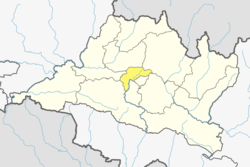
Chhaimale

Last updated
Chhaimale
छैमले
Chhaimale VDC.JPG
Nepal adm location map.svg
Red pog.svg
Chhaimale
Location in Nepal
Coordinates: 27°35′24″N85°15′36″E / 27.59000°N 85.26000°E / 27.59000; 85.26000
CountryFlag of Nepal.svg   Nepal
Province No. 3
District Kathmandu District
Population
 (2011)
  Total
4,216
  Religions
Hindu
Time zone UTC+5:45 (Nepal Time)
Nepali Housewife from Chhaimale Nepali Housewife.JPG
Nepali Housewife from Chhaimale

Chhaimale is a village and former Village Development Committee that is now part of Dakshinkali Municipality in Kathmandu District in Province No. 3 of central Nepal. At the time of the 2011 Nepal census it had a population of 4,216 living in 968 households. [1]

Contents

Toponymy

Linguistic origin

Etymology

“Chhai” comes from an old word meaning shade or coolness. “Male” refers to the sheltered side of a hill or a green area. It is said that the place was named for being a cool, shaded, and green area.

Chhai means “shade, shadow” — likely from the Nepali root छायाँ (chhāyā), which means “shadow” or “shade”; ultimately derived from Sanskrit छाया (chāyā).

Male (मले) is a local name or toponymic suffix, possibly of indigenous or regional origin with uncertain etymology. The toponym Chhaimale is descriptive in nature, referring to a shaded or sun-protected area, combining a Sanskrit-derived root with a local suffix.

References

  1. "National Population and Housing Census 2011" (PDF). Government of Nepal, National Planning Commission Secretariat, Central Bureau of Statistics. Archived from the original (PDF) on 2013-01-24. Retrieved 28 March 2014.