Dailekh District a part of Karnali Province, is one of the 77 districts of Nepal. The district, with Dailekh as its district headquarters, covers an area of 1,502 km2 (580 sq mi) and had a population of 225,201 in 2001 and 261,770 in 2011.

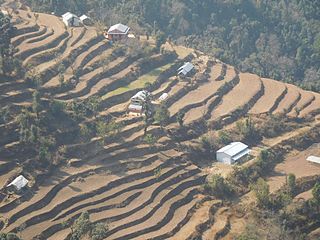
Kavrepalanchok District is one of the 77 districts of Nepal. The district, with Dhulikhel as its district headquarters, covers an area of 1,396 km2 (539 sq mi). It is a part of Bagmati Province and has a population of 364,039.

Sindhuli District, a part of the Bagmati Province, is one of the seventy-seven districts of Nepal, a landlocked country located in South Asia. The district, with Sindhulimadhi Kamalamai as its headquarters, covers an area of 2,491 km2 (962 sq mi). As per the 2011 census, Sindhuli District has a population of 296,192.
Bageshwari is a village and Village Development Committee in Bhaktapur District in the Bagmati Zone of central Nepal. At the time of the 2011 Nepal census it had a population of 5,385 with 1,137 houses. There were 2,609 males and 2,776 females at the time of census.

Bode is an ancient Newar city in the east corner of the Kathmandu Valley, Nepal, about eight miles from the capital city, Kathmandu.The city is famous for Biska Jatra and tongue piercing and Nilbharahi Naach. At the time of the 2011 Nepal census it had a population of 6,364 with 1,389 houses.
Chittpol is a village and former Village Development Committee in Bhaktapur District in the Bagmati Zone of central Nepal. In 2014, it was merged into the newly formed Suryabinayak Municipality by the Government of Nepal in order to remove all Village Development Committees in the Districts of Kathmandu and Bhaktapur. At the time of the 1991 Nepal census it had a population of 4,689 with 819 houses in it.
Chunikhel is a village and former Village Development Committee that is now part of Budanilkantha Municipality in Kathmandu District in Province No. 3 of central Nepal. At the time of the 2011 Nepal census it had a population of 4,449 living in 859 households. Chunikhel it has 15 VDC in total. It is located in 27°45'31.1"N 85°22'17.0"E just few kilometre away from heart of kathmandu. Chunikhel is gate for entering Shivapuri National park.

Lapsiphedi is a village and former Village Development Committee that is now part of Shankharapur Municipality in Kathmandu District in Province No. 3 of central Nepal. At the time of the 1991 Nepal census it had a population of 5,040 spread over 919 households.
Naikap Naya Bhanjyang is a village and former Village Development Committee that is now part of Chandragiri Municipality in Kathmandu District in Province No. 3 of central Nepal. At the time of the 1991 Nepal census it had a population of 4,425.

Ramkot is a village of the Nagarjun Municipality, Bagmati Province, Nepal. The 2011 Nepal census recorded that Ramkot had a population of 6,303 people in 1,427 independent households.
Hariharpur is a town in Chhireswarnath Municipality in Dhanusa District in the Janakpur Zone of south-eastern Nepal. The formerly Village Development Committee was converted into a municipality, merging with Ramdaiya, Sakhuwa Mahendranagar, Hariharpur and Digambarpur on 18 May 2014. At the time of the 1991 Nepal census it had a population of 6,259 persons residing in 1133 individual households.
Bhumidanda is a village development committee in Kabhrepalanchok District in Bagmati Province of central Nepal. At the time of the 1991 Nepal census it had a population of 3,383 and had 630 houses in it.
Kavre Nitya Chandeswori popularly known as "Kavre" is a village development committee in Kavrepalanchok District in the Bagmati Zone of central Nepal. Two of its V.D.C's are included in Dhulikhel Municipality in the year 2015 A.D. At the time of the 2011 Nepal census it had a population of 4,927 in 1,042 individual households.
Nala, is a specific region that expands from north western part of Kavrepalanchowk District to the eastern part of Bhaktapur District in the Bagmati Zone of central Nepal. At the time of the 1991 Nepal census, it had a population of 6327 in 1035 individual households.
Sitapur Pra. Da. is a town in Mirchaiya Municipality in Siraha District in the Sagarmatha Zone of south-eastern Nepal. The formerly village development committee was merged to form new municipality since 18 May 2014 along with existing Rampur Birta, Malhaniyakhori, Radhopur, Ramnagar Mirchaiya, Fulbariya, Sitapur PraDa and Maheshpur Gamharia Village Development Committees. At the time of the 1991 Nepal census it had a population of 4671 people living in 899 individual households.
Gamhariya was a village development committee in Rautahat District in the Narayani Zone of south-eastern Nepal.
Pipra Pokhariya is a village development committee in Rautahat District in the Narayani Zone of south-eastern Nepal. At the time of the 1991 Nepal census it had a population of 3538 people living in 699 individual households.

Tahoon is a village very development committee in Palpa District in the Lumbini Zone of southern Nepal. At the time of the 1991 Nepal census it had a population of 3776.

Gokarneshwor is a municipality in Kathmandu District in the Bagmati Province of Nepal that was established on 2 December 2014 by merging the former Village development committees Sundarijal, Nayapati, Baluwa, Jorpati and Gokarna. The office of the municipality is that of the former Jorpati village development committee. The river Bagmati has its origin as the name Bagh Dwar situated in the middle of the Shivapuri jungle in this municipality.

Chandragiri is a municipality in Kathmandu District in Bagmati Province of Nepal that was declared as municipality on 2 December 2014 by merging the former Village Development Committees Baad Bhanjyang, Balambu, Dahachok, Mahadevsthan, Machhegaun, Matatirtha, Naikap Naya Bhanjyang, Naikap Purano Bhanjyang, Satungal, Thankot and Tinthana. The urban administration is located in Balambu. The city's main attractions include Chandragiri Hill, Nepal with its Cable Car and Matatirtha which is famous for the Matatirtha Aunsi festival, a day to honour mothers and motherhood.

