The Kathmandu Valley, also known as the Nepal Valley or Nepa Valley, National Capital city, is a bowl-shaped valley located in the Himalayan mountains in Nepal. It lies at the crossroads of ancient civilizations of the Indian subcontinent and the broader Asian continent, and has at least 130 important monuments, including several pilgrimage sites for Hindus and Buddhists. There are seven World Heritage Sites within the valley.

Dhading District, a part of Bagmati Province, is one of the seventy-seven districts of Nepal. The district, with Dhading Besi as its district headquarters, covers an area of 1,926 square kilometres (744 sq mi), had a population of 338,658 in 2001 and 336,067 in 2011.
Nuwakot District (Nepali: नुवाकोट जिल्ला, a part of Bagmati Province, is one of the seventy-seven districts of Nepal. The district, with Bidur as its district headquarters, covers an area of 1,121 km2 and had a population of 288,478 in 2001 and 277,471 in 2011. It is a historically important district in Nepal. Prithvi Narayan Shah died in Devighat of Nuwakot.

Rukum District was a "hill" and "mountain" district some 280 km (170 mi) west of Kathmandu partially belonging to Lumbini Province and partially to Karnali Province before split into two districts Western Rukum and Eastern Rukum after the state's reconstruction of administrative divisions in 2017. Rukum covers an area of 2,877 km2 (1,111 sq mi) with population of 207,290 in 2011 Nepal census. Musikot was the district's administrative center.

Tamang is a term used to collectively refer to a dialect cluster spoken mainly in Nepal, Sikkim, West Bengal (Darjeeling) and North-Eastern India. It comprises Eastern Tamang, Northwestern Tamang, Southwestern Tamang, Eastern Gorkha Tamang, and Western Tamang. Lexical similarity between Eastern Tamang and other Tamang languages varies between 81% and 63%. For comparison, lexical similarity between Spanish and Portuguese, is estimated at 89%.

The Bishnumati River (Nepal Bhasa:𑐰𑐶𑐲𑑂𑐞𑐸𑐩𑐟𑐶 𑐏𑐸𑐳𑐶, Nepali: विष्णुमति नदी), flowing in the Kathmandu Valley, originates at Tokha on Shivapuri Mountain, north of Kathmandu. It flows through the western part of old Kathmandu city. It is a holy river for both Hindu and Buddhist people. Literally, Bishnumati means the beloved river of Lord Vishnu. Sobha Baghwati and Indrayani along with Kankeshowri temple - a few of the holiest places of the Kathmandu Valley are on the opposite banks of this river. Karbir Masan, a revered cemetery is also on the bank of this river. the tributaries of this river are Sapanatirtha Khola, Sangle Khola, Lhora Khola, and Binap Falls. Bisnap fall locates at the Shivapuri National Park.
Bidur is the capital of Nuwakot District in Bagmati Province, Nepal. At the time of the 1991 Nepal census it had a population of 18694 and had 3736 houses in it.
Baluwa is a village and former Village Development Committee that is now part of Gokarneshwar Municipality in Kathmandu District in Bagmati Province of central Nepal. At the time of the 2011 Nepal census it had a population of 5,467 and had 1,204 houses in it. It is located at north-east side from the capital city of Nepal. It touch Nuwakot District to the north and Gorkna VDC to the south. In east side, there is Nayapati VDC and in west Kapan VDC.

Budhanilkantha is a city and municipality in Kathmandu district of Bagmati province of Nepal. It is the 3rd largest city in the Kathmandu Valley after Kathmandu and Lalitpur. As per 2021 Nepal census, the city population was 179,688 and 26,678 households.
Chunikhel is a village and former Village Development Committee that is now part of Budanilkantha Municipality in Kathmandu District in Province No. 3 of central Nepal. At the time of the 2011 Nepal census it had a population of 4,449 living in 859 households. Chunikhel it has 15 VDC in total. It is located in 27°45'31.1"N 85°22'17.0"E just few kilometre away from heart of kathmandu. Chunikhel is gate for entering Shivapuri National park.

Sundarijal is a village and former Village Development Committee that is now part of Gokarneshwar Municipality in Kathmandu District in Province No. 3 of central Nepal.
Tokha Chandeshwari is a village and former Village Development Committee that is now part of Tokha Municipality in Kathmandu District in Province No. 3 of central Nepal. At the time of the 2011 Nepal census it had a population of 3,961. Tokha Chandeshwari now is part of Tokha municipality.
Tokha Saraswati is a village and former Village Development Committee that is now part of Tokha Municipality in Kathmandu District in Province No. 3 of central Nepal. At the time of the 2011 Nepal census it had a population of 5,152.
Gotikhel is a village and former Village Development Committee that is now part of Mahankal Rural Municipality in Province No. 3 of central Nepal. At the time of the 1991 Nepal census it had a population of 1654 living in 323 individual households.

Shivapuri Nagarjun National Park is the ninth national park in Nepal and was established in 2002. It is located in the country's mid-hills on the northern fringe of the Kathmandu Valley and named after Shivapuri Peak at 2,732 m (8,963 ft) altitude. It covers an area of 159 km2 (61 sq mi) in the districts of Kathmandu, Nuwakot and Sindhupalchowk, adjoining 23 Village Development Committees. In the west, the protected area extends to the Dhading District.

Tokha is a municipality in Kathmandu District in Bagmati Province of Nepal that was established on 2 December 2014 by merging the former Village development committees Dhapasi, Jhor Mahankal, Gongabu, Tokha Chandeshwari and Tokha Saraswati on 2 December 2014. The municipality derives its name from the historical town of Tokha.

Pasikot, situated at Budhanilkantha Municipality, is a village in Budhanilkantha in Kathmandu District in Bagmati Province before being incorporated into the city of Budhanilkantha in Nepal. At the time of the 2011 Nepal census it had a population of 15,421.

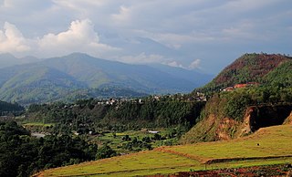
Suryachaur is a Hill station to see the Langtang Himalayan Range as well as entire Likhu Valley of Nuwakot District in Bagmati Province of central Nepal.
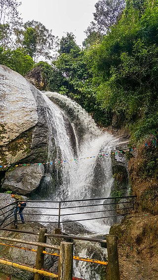
Jhor waterfall is located in the northern hills of Kathmandu near Tokha. The stream from Shivapuri National Park feeds the waterfall. The waterfall is about 11 km from Ring Road from Samakhushi. There is a temple of Shiva near the waterfall which opens on Saturdays and Mondays. There is also a zipline near the waterfall that was constructed to boost the tourism.
Shivapuri is a Rural municipality located within the Nuwakot District of the Bagmati Province of Nepal. The municipality spans 101.5 square kilometres (39.2 sq mi) of area, with a total population of 20,769 according to a 2011 Nepal census.