Myanglung is a municipality and the district headquarters of Terhathum District of Koshi Province in eastern Nepal. The "myang" means cat and "lung" means stone in Limbu language.The story is that the cat (myang) in ancient time, pawed the stone (lung) in anger. The municipality is situated at an elevation of about 1500 metres above sea level. Myanglung was converted into a municipality from a village development committee on 18 May 2014, merging the existing village development committees of Myanglung, Piple, Jirikhimti, Ambung, Sabla and Tamphula. According to the census of 2011 the total population of Myanglung is 19,659 including five VDCs.
Chainpur is a municipality in Sankhuwasabha District in the Koshi Province of north-eastern Nepal. It was formed by merging five villages i.e. Chainpur, Siddhakali, Siddhapokhari, Baneshwar and Kharang. The municipality was implemented on 18 May 2014. At the time of the 1991 Nepal census it had a population of 4933 people in 948 households.

Siddhicharan is a municipality and the district headquarter of Okhaldhunga District in Province No. 1 of Nepal that was established in May 2014 by merging the two former Village development committees Andheri, Thulachhap, Jyamire, Salleri, Rumjatar and Okhaldhunga. It is named after the Nepali poet Siddhicharan Shrestha.

Nagarjun is a municipality in Kathmandu District in Bagmati Province of Nepal. It was formed on 2 December 2014 by merging the former VDCs of Bhimdhunga, Ichangu Narayan, Ramkot, Syuchatar and Sitapaila. The office of the municipality is located at Harisiddhi, Sitapaila. There are ten wards in the municipality.

Tarakeshwar is a municipality in Kathmandu District in Bagmati Province of Nepal that was established on 2 December 2014 by merging the former Village development committees Dharmasthali, Futung, Goldhunga, Jitpurphedi, Kavresthali, Manmaiju and Sangla. The office of the municipality is that of the former Dharmasthali village development committee.

Laligurans is a municipality located in Terhathum District in the Koshi Province of eastern Nepal. After the government announcement, the municipality was established on 19 September 2015 by merging the existing Basantapur, Phulek, Dangpa, Sungnam and Solma village development committees (VDCs). The center of the municipality is established in Basantpur. At the time of the 2011 Nepal census after merging the five VDCs population it had a total population of 16,934 persons. After the government decision the number of municipalities has reached 217 in Nepal.

Bhanu is a municipality of Tanahun District in Gandaki Province of western Nepal. The municipality was established on 19 September 2015 by merging the existing Bhanu village development committee or VDC, Barbhanjyang VDCs, Rupakot (VDC), Tanahunsur Village Development Committee, Purkot VDC, Mirlung VDC, Satiswara VDC, Risti VDC, Basantapur VDC and Chok Chisapani VDC. The center of the municipality is established in former VDC Office of Bhanu. After merging the population of all of the VDCs, it had a total population of 46,179 according to 2011 Nepal census. After the government decision the number of municipalities has reached 217 in Nepal. Nepali poet Bhanubhakta Acharya was born in Bhanu Municipality. It was named after him.
Mahalaxmi is a municipality that lies in the north-eastern part of the Lalitpur district of Nepal. As per the declaration by the government of Nepal in 2015, it was created through the merger of the Village development committees Imadol, Lubhu, Tikathali, Siddhipur and Lamatar. The city derives its name from the Mahalaxmi-Mahabhairav Temple in Lubhu. The city's total area is 26.5 square kilometres. The municipality has a total number of 10 wards. The old VDC offices are used as joint ward office now.
Phakphokthum is a rural municipality, one of six located in Ilam District of Koshi Province of Nepal. A total of 10 municipalities are found in Ilam, of which 4 are urban and 6 are rural.
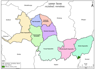
Udayapurgadhi Rural Municipality is a rural municipality in Udayapur District of Koshi Province in Nepal. There are 4 rural municipalities in Udayapur District. There are 8 wards in this municipality. According to 2011 census of Nepal, the total population of the municipality is 30,731 and total area is 269.51 km². The headquarter of the municipality is in Panchawati
Panchkhapan (Nepali: पाँचखप्पन) is an urban municipality out of five urban municipalities of Sankhuwasabha District in Koshi Province of Nepal. It lies on 87°12'12" E to 87°26'45" E Longitude and 27°17'37.4" N to 27°24'38" N Latitude. The municipality was established on 3 March 2017 merging former VDCs: Syabun, Jaljala and Wana. The area of the municipality is 148.03KM2 and according to 2011 census of Nepal the population of the municipality is 17,521.
Madi is a municipality in Sankhuwasabha District of Koshi Province in Nepal. It is a municipality out of 5 municipalities in Sankhuwasabha District. Total area of the municipality is 110.10 km (68.41 mi) and according to 2011 census of Nepal, the population of this municipality is 14,470. The municipality was established in March 2017 merging some former VDCs: e.g. Madi Mulkharka, Madi Rambeni and Mawadin. The municipality is divided into 13 wards. The headquarter of the municipality is in Okharbote.
Mahalaxmi is a municipality in Dhankuta District of Koshi Province in Nepal. It is a municipality out of three urban municipalities in Dhankuta District. Total area of the municipality is 126.3 km (78.5 mi) and according to 2011 census of Nepal, the population of this municipality is 24,800. The municipality is divided into nine wards. The headquarter of the municipality is in Jitpur Bazar.
Gokulganga Rural Municipality is a Rural municipality in Ramechhap District of Bagmati Province in Nepal.
Chhathar Jorpati is a rural municipality (gaunpalika) out of four rural municipality located in Dhankuta District of Koshi Province of Nepal. There are a total of 7 municipalities in Dhankuta in which 3 are urban and 4 are rural.
Buddhashanti is a rural municipality (gaunpalika) out of seven rural municipality located in Jhapa District of Koshi Province of Nepal. Buddhashanti, according to Ministry of Federal Affairs and Local Development has an area of 79.78 square kilometres (30.80 sq mi) and the total population of the municipality is 41,615 as of Census of Nepal 2011.
Makalu is a rural municipality (gaunpalika) out of five rural municipality located in Sankhuwasabha District of Koshi Province of Nepal. There are a total of 10 municipalities in Sankhuwasabha in which 5 are urban and 5 are rural.
Chhathar is a rural municipality (gaunpalika) out of four rural municipality located in Tehrathum District of Koshi Province of Nepal. There are a total of 6 municipalities in Tehrathum in which 2 are urban and 4 are rural.
Thasang Rural Municipality is a Gaunpalika, or rural municipality, in Mustang district in Gandaki Province of Nepal. On 12 March 2017, the government of Nepal implemented a new local administrative structure, in which Village Development Committees were replaced by municipal and Village Councils. Thasang is one of these 753 local units.
Gharapjhong Rural Municipality (Gharapjhong Gaupalika) (Nepali: घरपझोङ गाउँपालिका) is a Gaunpalika, or rural municipality, in Mustang district in Gandaki Province of Nepal. On 12 March 2017, the government of Nepal implemented a new local administrative structure, in which Village Development Committees were replaced with municipal and Village Councils. Gharapjhong is one of these 753 local units.