
Pennypack Creek is a 22.6-mile-long (36.4 km) creek in southeastern Pennsylvania in the United States. It runs southeast through lower Bucks County, eastern Montgomery County and the northeast section of Philadelphia, before emptying into the Delaware River.

Poquessing Creek is a 10.3-mile-long (16.6 km) creek, a right tributary of the Delaware River, that forms part of the boundary between Bucks County and the northeast section of Philadelphia, Pennsylvania. It has been part of the boundary between Bucks and Philadelphia counties since 1682.

Frankford Creek is a minor tributary of the Delaware River in southeast Pennsylvania. It derived its name from the nearby town of Frankford, Philadelphia County. The stream originates as Tookany Creek at Hill Crest in Cheltenham Township and meanders eastward, then southeastward, throughout Cheltenham Township, until a sharp bend near the Philadelphia border at Lawncrest, where the place names Toxony and Tookany were used in historic times; the stream is still known as Tookany Creek in this region, where it flows southwest. Turning south into Philadelphia at the crotch of Philadelphia's V-shaped border, the creek is called Tacony Creek; from here southward, it is considered the informal boundary separating Northeast Philadelphia from the rest of the city. The Philadelphia neighborhoods of Olney and Feltonville lie on the western side of the stream in this area while Northwood, Lawncrest, Summerdale, and Frankford lie on the eastern side. It continues to be called the Tacony at least until the smaller Wingohocking Creek merges with it in Juniata Park, within the city-owned golf course. Beyond Castor Avenue it is known as Frankford Creek until the stream's confluence with the Delaware River in the Bridesburg neighborhood of Philadelphia. The section of stream known as Frankford Creek is 3.1 miles (5.0 km) long, and the upstream section known as Tacony Creek, from Hill Crest, is 11.1 miles (17.9 km) long.

The Detroit–Superior Bridge is a 3,112-foot-long (949 m) through arch bridge over the Cuyahoga River in Cleveland, Ohio. The bridge links Detroit Avenue on Cleveland's west side and Superior Avenue on Cleveland's east side, terminating west of Public Square. Construction by the King Bridge Company began in 1914 and completed in 1918, at a cost of $5.4 million. It was the first fixed high level bridge in Cleveland, and the third high-level bridge above the Cuyahoga. At the time of its completion, the bridge was the largest steel and concrete reinforced bridge in the world.
The Albertus L. Meyers Bridge is a reinforced concrete open-spandrel arch bridge located in Allentown, Pennsylvania. The bridge is "one of the earliest surviving examples of monumental, reinforced concrete construction," according to the American Society of Civil Engineers.

The Queen Avenue Bridge is a reinforced concrete single-span barrel arch bridge in Minneapolis that spans the tracks used by the Minnesota Streetcar Museum. The bridge was built in 1905 and is listed on the National Register of Historic Places.

The County Farm Bridge is a historic stone arch bridge in Wilton, New Hampshire. Built in 1885, it carries Old County Farm over Whiting Brook, just south of its northern junction with Burton Highway in a rural section of northwestern Wilton. It is an unusually late and well-preserved example of a 19th-century stone arch bridge, and was listed on the National Register of Historic Places in 1981.

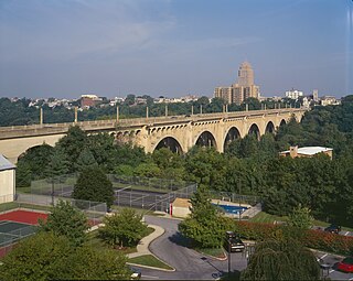
The Wissahickon Memorial Bridge, originally called and still also known as the Henry Avenue Bridge, is a stone and concrete bridge that carries Henry Avenue over Wissahickon Creek and Lincoln Drive in Fairmount Park in Philadelphia, Pennsylvania.

Harrison Avenue Bridge was a concrete deck arch bridge carrying Harrison Avenue in Scranton, Pennsylvania, United States. Its three spans included an open-spandrel ribbed arch over Roaring Brook, flanked by two closed-spandrel arches. The southwestern closed-spandrel arch spanned the former Lackawanna and Wyoming Valley Railroad, converted to highway use in 1964 as the Central Scranton Expressway. The northeastern closed-spandrel arch spans the former Delaware, Lackawanna and Western Railroad, now a heritage railroad operated by Steamtown National Historic Site.

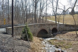
Bridge in Radnor Township No. 2 is a historic brick and concrete arch bridge located at Villanova in Delaware County, Pennsylvania. It was built in 1905, and is a 75-foot-long (23 m), arch bridge with a single arch with a 10-foot-long (3.0 m) span. It features an ornate parapet cap. It spans the Meadowbrook Run.
Bridge in Radnor Township No. 1 is a historic stone arch bridge that carries Goshen Road over Darby Creek to Darby Paoli Road in Radnor, Delaware County, Pennsylvania. The current structure was built in 1905, and is an 80-foot-long (24 m), arch bridge with three arch spans of 45-foot (14 m), 19-foot (5.8 m), and 16-foot-long (4.9 m). It features an unfinished stone parapet cap. It spans the Darby Creek.

Frantz's Bridge was a historic stone arch bridge located at Lowhill Township, Lehigh County, Pennsylvania. It was built in 1887, and is a 166-foot-long (51 m), multiple-span bridge, with three spans each measuring 32 feet (9.8 m) long. It crossed Jordan Creek.

Centennial Bridge was a historic stone arch bridge located in Center Valley, Lehigh County, Pennsylvania. It was built in 1876, and was a 233-foot-long (71 m) bridge, with three 23-foot-long (7.0 m), horseshoe shaped arches. It crossed Saucon Creek.
The First Avenue Bridge is a historic structure located in downtown Cedar Rapids, Iowa, United States. It carries U.S. Route 151 for 697 feet (212 m) over the Cedar River. The original six-span concrete arch structure was completed in 1920 for $420,000. It was designed by Marsh Engineering Company and built by Koss Construction Co., both of Des Moines. Consulting engineer Ned L. Ashton of Iowa City designed the 1960s remodel. He had all of the concrete work above the original arches torn out and the bridge rebuilt as an open-spandrel structure. The rebuild also included a wider deck to accommodate increased traffic and aluminum railings. While the bridge's original structural integrity has been compromised, this is the first notable concrete spandrel arch reconstruction in Iowa and possibly in the country. The bridge was listed on the National Register of Historic Places in 1998.

Belmont Avenue Bridge in Philadelphia is a historic stone arch bridge located in Fairmount Park, Philadelphia, Pennsylvania. It was built in 1896, and is a single-span bridge. The arch measures 29-foot-wide (8.8 m).
Barto Bridge is a historic concrete arch bridge located at Washington Township in Berks County, Pennsylvania. It is a single span 82-foot-long (25 m), concrete barrel arch bridge, constructed in 1908. It crosses a tributary of Perkiomen Creek.

Ironstone Bridge is a historic concrete arch bridge located at Douglass Township in Berks County, Pennsylvania. It is a single span 104-foot-long (32 m), concrete barrel arch bridge, constructed in 1907. It crosses Ironstone Creek.

Black Rock Bridge is a historic concrete arch bridge carrying Pennsylvania Route 113 across the Schuylkill River between Phoenixville, Chester County, Pennsylvania, and Upper Providence Township, Montgomery County, Pennsylvania. It has five spans; three main spans are each 116 feet (35 m) long and flanked by two 103-foot-long (31 m) spans. The bridge was constructed in 1927, and features open-spandrel arches and solid concrete parapet walls.
Marshall's Bridge is a historic stone arch bridge located in East Brandywine Township, Chester County, Pennsylvania. It spans Culbertson Run and is right next to Bridge Mill Farm. It has two arch spans, one is 20-foot-long (6.1 m) and the second is 19-foot-long (5.8 m). The bridge was constructed in 1903 of stone with brick arch rings.

The Marshall Avenue Bridge is a bridge carrying Marshall Avenue over Rice Creek in Marshall, Michigan. It was listed on the National Register of Historic Places in 2001. The construction of the bridge, as a multi-span stone masonry arch type, is extremely rare in Michigan because of the lack of good sources of stone material. It is the longest known stone highway bridge in Michigan.


