Vaughan is a city in Ontario, Canada. It is located in the Regional Municipality of York, just north of Toronto. Vaughan was the fastest-growing municipality in Canada between 1996 and 2006 with its population increasing by 80.2% during this time period and having nearly doubled in population since 1991. It is the fifth-largest city in the Greater Toronto Area, and the 17th-largest city in Canada.

The Regional Municipality of York, also called York Region, is a regional municipality in Southern Ontario, Canada, between Lake Simcoe and Toronto. The region was established after the passing of then Bill 102, An Act to Establish The Regional Municipality of York, in 1970. It replaced the former York County in 1971, and is part of the Greater Toronto Area and the inner ring of the Golden Horseshoe. The regional government is headquartered in Newmarket.
King's Highway 407, commonly referred to as Highway 407 and colloquially as the "four-oh-seven", is a tolled 400-series highway in the Canadian province of Ontario. Comprising a privately leased segment as well as a publicly owned segment, the route spans the entire Greater Toronto Area (GTA) around the city of Toronto, travelling through the suburbs of Burlington, Oakville, Mississauga, Brampton, Vaughan, Markham, Pickering, Whitby, and Oshawa before ending in Clarington, north of Orono. At 151.4 km long, this is the fourth-longest freeway in Ontario's 400 series network, after Highways 417, 400, and 401. The segment between Burlington and Brougham in Pickering is leased to and operated by the 407 ETR Concession Company Limited and is officially known as the 407 Express Toll Route (407 ETR). It begins at the junction of the Queen Elizabeth Way (QEW) and Highway 403 in Burlington, and travels 108.0 km (67.1 mi) across the GTA to Brock Road in Pickering. East of Brock Road, the tollway continues east as Highway 407, a toll route operated by the provincial government, for 43.4 km (27.0 mi) to Highway 35/115 in Clarington. The route interchanges with nine freeways: the QEW, Highway 403, Highway 401, Highway 410, Highway 427, Highway 400, Highway 404, Highway 412, and Highway 418. Highway 407 is an electronically operated toll highway; there are no toll booths along the length of the route. Distances are calculated automatically using transponders or automatic number-plate recognition, which are scanned at entrance and exit portals.

The 400-series highways are a network of controlled-access highways in the Canadian province of Ontario, forming a special subset of the provincial highway system. They are analogous to the Interstate Highway System in the United States or the Autoroute system of neighbouring Quebec, and are regulated by the Ministry of Transportation of Ontario (MTO). The 400-series designations were introduced in 1952, although Ontario had been constructing divided highways for two decades prior. Initially, only Highways 400, 401 and 402 were numbered; other designations followed in the subsequent decades. The network is situated almost entirely in Southern Ontario, although Highway 400 extends into the more remote northern portion of the province.
King's Highway 427, also known as Highway 427 and colloquially as the 427, is a 400-series highway in the Canadian province of Ontario that runs from the Queen Elizabeth Way (QEW) and Gardiner Expressway in Toronto to Major Mackenzie Drive in Vaughan. It is Ontario's second busiest freeway by volume and the third busiest in North America, behind Highway 401 and Interstate 405 in California. Like Highway 401, a portion of the route is divided into a collector-express system with twelve to fourteen continuous lanes. Notable about Highway 427 are its several multi-level interchanges; the junctions with the QEW/Gardiner Expressway and Highway 401 are two of the largest interchanges in Ontario and were constructed between 1967 and 1971, while the interchanges with Highway 409 and Highway 407 were completed in 1992 and 1995, respectively.
King's Highway 400, commonly referred to as Highway 400, historically as the Toronto–Barrie Highway, and colloquially as the 400, is a 400-series highway in the Canadian province of Ontario linking the city of Toronto in the urban and agricultural south of the province with the scenic and sparsely populated central and northern regions. The portion of the highway between Toronto and Lake Simcoe roughly traces the route of the Toronto Carrying-Place Trail, a historic trail between the Lower and Upper Great Lakes. North of Highway 12, in combination with Highway 69, it forms a branch of the Trans-Canada Highway (TCH), the Georgian Bay Route, and is part of the highest-capacity route from southern Ontario to the Canadian West, via a connection with the mainline of the TCH in Sudbury. The highway also serves as the primary route from Toronto to southern Georgian Bay and Muskoka, areas collectively known as cottage country. The highway is patrolled by the Ontario Provincial Police and has a speed limit of 100 km/h (62 mph), except for the section south of Highway 401, where the speed limit is 80 km/h (50 mph) and the 60 km (37 mi) stretch between MacTier and Nobel, where the speed limit was raised to 110 km/h (68 mph) on April 22, 2022.

Woodbridge is a very large suburban community in Vaughan, Ontario, Canada, along the city's border with Toronto. It occupies the city's entire southwest quadrant, west of Highway 400, east of Highway 50, north of Steeles Avenue, and generally south of Major Mackenzie Drive. It was once an independent village before being amalgamated with nearby communities to form the city in 1971. Its traditional downtown core is the Woodbridge Avenue stretch between Islington Avenue and Kipling Avenue north of Highway 7.
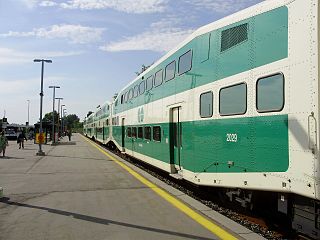
Barrie is one of the seven train lines of the GO Transit system in the Greater Toronto Area, Ontario, Canada. It extends from Union Station in Toronto in a generally northward direction to Barrie, and includes ten stations along its 101.4 kilometres (63.0 mi) route. From 1982 to 1990 and again from 1993 to 2007, it was known as the Bradford line, named after its former terminus at Bradford GO Station until the opening of Barrie South GO Station.
King City is an unincorporated Canadian community in the township of King, Ontario, located 40 kilometres (25 mi) north of Toronto. It is the largest community in King township, with 2,730 dwellings and a population of 8,396 as of the 2021 Canadian census.

Maple is a neighbourhood in Vaughan, York Region, Ontario, Canada. It is located northwest of Toronto. Maple was founded as the village of Maple, located at the intersection of Major Mackenzie Drive and Keele Street.
King's Highway 27, commonly referred to as Highway 27, is a provincially maintained highway in the Canadian province of Ontario. The Ministry of Transportation of Ontario was once responsible for the length of the route, when it ran from Long Branch to Highway 93 in Waverley. Highway 27 followed a mostly straight route throughout its length, as it passed through the suburbs of Toronto, then north of Kleinburg the vast majority of the highway was surrounded by rural farmland. Today, only the southernmost 1.6 km (1 mi) from Highway 427 north to Mimico Creek is under provincial jurisdiction, the remainder of the route is maintained by the city of Toronto, York Region and Simcoe County.

Dufferin Street is a major north–south street in Toronto, Vaughan and King, Ontario, Canada. It is a concession road, two concessions (4 km) west of Yonge Street. The street starts at Exhibition Place, continues north to Toronto's northern boundary at Steeles Avenue with some discontinuities and continues into Vaughan, where it is designated York Regional Road 53. The street is named for Frederick Hamilton-Temple-Blackwood, 1st Marquess of Dufferin and Ava, who served as Governor General of Canada from 1872 to 1878. Prior to 1878 the street was labelled as Western City Limits or Sideline Road south off Bloor. In 2003 and 2007, it was voted as one of "Ontario's Worst 20 Roads" in the Ontario's Worst Roads poll organized by the Canadian Automobile Association.

Kipling Avenue is a street in the cities of Toronto and Vaughan in Ontario, Canada. It is a concession road, 6 concessions (12 km) west from Yonge Street, and is a major north–south arterial road. It consists of three separate sections, with total combined length of 26.4 km. (16.4 mi.).

Langstaff GO Station is a train and bus station in the GO Transit network located in Richmond Hill, Ontario in Canada. It is a stop on the Richmond Hill line train service.
Richmond Hill Centre Terminal is a York Region Transit, Viva, and GO Transit bus terminal in Richmond Hill, Ontario. Despite its name, the terminal is not located in downtown Richmond Hill, but is situated 4 km to the south at the city's southern limits, bordering Vaughan and Markham, near the connecting road that links the grade-separated Yonge Street and Highway 7 intersection. It opened on September 4, 2005. It is immediately west of the Langstaff GO train station, but is separated by the tracks. A pedestrian bridge over the tracks was opened in March 2008 to connect the bus terminal and the train station. Public washrooms were added to the terminal in December 2012.

Black Creek is a river in the Golden Horseshoe region of Ontario, Canada. It flows from the city of Vaughan in the Regional Municipality of York to the Humber River in Toronto. Black Creek is smaller than most of the waterways in the Greater Toronto Area.

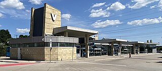
Vaughan Metropolitan Centre is the city centre of Vaughan, Ontario, Canada. Measuring 179 hectares, the district is located at the intersection of Highway 7 and Jane Street, northeast of the Highway 400 and Highway 407 interchange, at the site of the historic farming community of Edgeley within the larger district of Concord. The district is served by the TTC subway station of the same name, which is the northwestern terminus of Line 1 Yonge–University of the Toronto subway system. It is also a major transit hub for York Region Transit (YRT), as well as Viva and Züm bus rapid transit services.

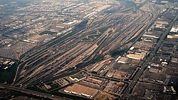
MacMillan Yard is the main Toronto-area railway classification yard for Canadian National Railway (CN), and is located in the nearby suburb of Vaughan, Ontario. It is the second largest railway classification yard in Canada, after CN's Symington Yard in Winnipeg, Manitoba. It was originally opened in 1965 as Toronto Yard, but was renamed MacMillan Yard in 1975 after former CN president Norman John MacMillan.
The City of Vaughan in Ontario, Canada offers a complex transportation infrastructure, which includes highways, public transit, regional roads, municipality-funded roads, and train services.
King's Highway 413, known as the GTA West Corridor or GTA West until 2021, is a proposed 400-series highway and bus transitway in the western Greater Toronto Area of the Canadian province of Ontario. The approximately 52-kilometre (32 mi) route is currently undergoing planning and analysis under an environmental impact assessment (EA) by the Ministry of Transportation of Ontario (MTO) and the Government of Ontario. If approved, a new four-to-six lane controlled-access highway would be built between the existing interchange of Highway 401 and the 407 ETR at the Halton–Peel boundary, and Highway 400 north of Vaughan. In addition, two new extensions would be built to connect Highway 410 and Highway 427 with Highway 413.