
El Dorado County, officially the County of El Dorado, is a county located in the U.S. state of California. As of the 2020 census, the population was 191,185. The county seat is Placerville. The county is part of the Sacramento-Roseville-Arden-Arcade, CA Metropolitan Statistical Area. It is located entirely in the Sierra Nevada, from the historic Gold Country in the western foothills to the High Sierra in the east. El Dorado County's population has grown as Greater Sacramento has expanded into the region. Where the county line crosses US 50 at Clarksville, the distance to Sacramento is 15 miles (24 km). In the county's high altitude eastern end at Lake Tahoe, environmental awareness and environmental protection initiatives have grown along with the population since the 1960 Winter Olympics, hosted at the former Squaw Valley Ski Resort in neighboring Placer County.

Placerville is a city in and the county seat of El Dorado County, California, United States. The population was 10,747 as of the 2020 census, up from 10,389 as of the 2010 census. It is part of the Sacramento–Arden-Arcade–Roseville Metropolitan Statistical Area.

Placerville is a populated place in Boise County, Idaho, United States. The population was 53 at the 2010 census. It is part of the Boise City–Nampa, Idaho Metropolitan Statistical Area.
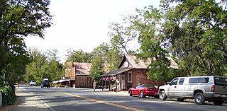
Coloma is a census-designated place in El Dorado County, California, US. It is approximately 36 miles (58 km) northeast of Sacramento, California. Coloma is most noted for being the site where James W. Marshall found gold in the Sierra Nevada foothills, at Sutter's Mill on January 24, 1848, leading to the California Gold Rush. Coloma's population is 529.
Folsom Lake College (FLC) is a public community college in Folsom, California. It is part of California Community Colleges system and the Los Rios Community College District. Folsom Lake College serves the community with classes offered at its main Folsom campus at 10 College Parkway, two outreach centers, and various off-site locations nearby. As of Fall 2005, Folsom Lake College enrolled approximately 6,600 students choosing among approximately 1,000 different course offerings. Those students were served by 74 full-time faculty, including 9 counselors, 180 part-time faculty, 69 classified staff, and eight administrators. The college offers students over 30 different Associate of Arts or Science degree options, as well as over 30 certificate alternatives. The college's mascot is the Falcons and its colors are teal and black. The current president is Art Pimental who began in 2022.

Marshall Gold Discovery State Historic Park is a state park of California, United States, marking the discovery of gold by James W. Marshall at Sutter's Mill in 1848, sparking the California Gold Rush. The park grounds include much of the historic town of Coloma, California, which is now considered a ghost town as well as a National Historic Landmark District. The park contains the California Historical Landmarks: a monument to commemorate James Marshall (#143), the actual spot where he first discovered gold in 1848 (#530). Established in 1942, and Coloma Road (#748),. The park now comprises 576 acres (233 ha) in El Dorado County.
El Dorado High School is a public high school in Placerville, California, United States. EDHS is one of six high schools in the El Dorado Union High School District, it is a California Distinguished School.
El Dorado Adventist School is a non-profit, WASC accredited, coeducational K-8 school owned and operated by local church constituencies and the Northern California Conference of Seventh-day Adventists. It is a part of the Seventh-day Adventist education system, the world's second largest Christian school system. It is in the Sierra foothill community of Placerville, California, United States.

U.S. Route 50 (US 50) is a transcontinental United States Numbered Highway, stretching from West Sacramento, California, in the west to Ocean City, Maryland, in the east. The California portion of US 50 runs east from Interstate 80 (I-80) in West Sacramento to the Nevada state line in South Lake Tahoe. A portion in Sacramento also has the unsigned designation of Interstate 305. The western half of the highway in California is a four-or-more-lane divided highway, mostly built to freeway standards, and known as the El Dorado Freeway outside of downtown Sacramento. US 50 continues as an undivided highway with one eastbound lane and two westbound lanes until the route reaches the canyon of the South Fork American River at Riverton. The remainder of the highway, which climbs along and out of the canyon, then over the Sierra Nevada at Echo Summit and into the Lake Tahoe Basin, is primarily a two-lane road.

The Church of Our Saviour is a historic Carpenter Gothic Episcopal church located at 2979 Coloma Street, in Placerville, El Dorado County, California, in the United States. The church is part of the Episcopal Diocese of Northern California. On November 17, 1977, it was listed in the National Register of Historic Places as the Episcopal Church of Our Saviour.
Gold Hill is an unincorporated community in El Dorado County, California. It is located 2.5 miles (4.0 km) south of Coloma, at an elevation of 1621 feet.
Latrobe is an unincorporated community in El Dorado County, California. Today a small community with a 2010 census population of 219, in its heyday it was an important railroad town with a population of 700 to 800.
Nashville is an unincorporated community in El Dorado County, California. It is located on the North Fork of the Cosumnes River 10.5 miles (17 km) south of Placerville, at an elevation of 863 feet.
Logtown, also known as Empire City, is a former mining town located on California State Route 49 about 3 miles (4.8 km) southwest of Placerville in El Dorado County, California. It first appeared in the US census in 1850, however the exact date of the town's founding is unclear. The town would become a small resting point mentioned in passing by most in El Dorado county.
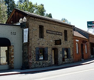
The Fountain-Tallman Soda Works is a historic building in Placerville, El Dorado County, California. It currently houses the Fountain & Tallman Museum, which is owned and operated by the El Dorado County Historical Society. The rustic vernacular Victorian stone and brick building, of the Gold Country, was placed on the National Register of Historic Places on September 13, 1984.
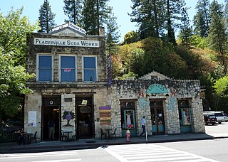
The John Pearson Soda Works, also referred to as the Placerville Soda Works, is a historic rustic vernacular Victorian brick building in Placerville, El Dorado County, California. The building, in the Gold Country region, was placed on the National Register of Historic Places (NRHP) on December 12, 1985. The building housed the Cozmic Café coffee shop and venue from 2003 until 2018.

The Combellack–Blair House is a historic house in the Gold Rush town of Placerville, in El Dorado County, California, built in 1895. The landmark house was placed on the National Register of Historic Places (NRHP) on February 14, 1985.
El Dorado Indian War (1850–1851) was a conflict between Native Americans and miners and California State Militia in what was then the county of El Dorado in California.
Alexander Howison Murray Jr. (1907–1993), known as Sandy Murray, was a two-time mayor of Placerville, California and three-time president of the county's chamber of commerce, who championed regional development, including the building of U.S. Route 50 in California (US 50) and was a regular page-one name in the Placerville Mountain Democrat.
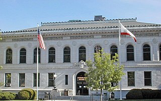
The Superior Court of California, County of El Dorado, also known as the El Dorado County Superior Court, is the branch of the California superior court with jurisdiction over El Dorado County.


