Related Research Articles

Granite is a coarse-grained (phaneritic) intrusive igneous rock composed mostly of quartz, alkali feldspar, and plagioclase. It forms from magma with a high content of silica and alkali metal oxides that slowly cools and solidifies underground. It is common in the continental crust of Earth, where it is found in igneous intrusions. These range in size from dikes only a few centimeters across to batholiths exposed over hundreds of square kilometers.

A batholith is a large mass of intrusive igneous rock, larger than 100 km2 (40 sq mi) in area, that forms from cooled magma deep in the Earth's crust. Batholiths are almost always made mostly of felsic or intermediate rock types, such as granite, quartz monzonite, or diorite.

Dacite is a volcanic rock formed by rapid solidification of lava that is high in silica and low in alkali metal oxides. It has a fine-grained (aphanitic) to porphyritic texture and is intermediate in composition between andesite and rhyolite. It is composed predominantly of plagioclase feldspar and quartz.
Andesite is a volcanic rock of intermediate composition. In a general sense, it is the intermediate type between silica-poor basalt and silica-rich rhyolite. It is fine-grained (aphanitic) to porphyritic in texture, and is composed predominantly of sodium-rich plagioclase plus pyroxene or hornblende.

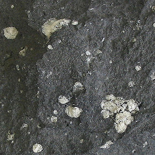
Anorthosite is a phaneritic, intrusive igneous rock characterized by its composition: mostly plagioclase feldspar (90–100%), with a minimal mafic component (0–10%). Pyroxene, ilmenite, magnetite, and olivine are the mafic minerals most commonly present.

Intrusive rock is formed when magma penetrates existing rock, crystallizes, and solidifies underground to form intrusions, such as batholiths, dikes, sills, laccoliths, and volcanic necks.
The tholeiitic magma series is one of two main magma series in subalkaline igneous rocks, the other being the calc-alkaline series. A magma series is a chemically distinct range of magma compositions that describes the evolution of a mafic magma into a more evolved, silica rich end member. Rock types of the tholeiitic magma series include tholeiitic basalt, ferro-basalt, tholeiitic basaltic andesite, tholeiitic andesite, dacite and rhyolite. The variety of basalt in the series was originally called tholeiite but the International Union of Geological Sciences recommends that tholeiitic basalt be used in preference to that term.
Adakites are volcanic rocks of intermediate to felsic composition that have geochemical characteristics of magma originally thought to have formed by partial melting of altered basalt that is subducted below volcanic arcs. Most magmas derived in subduction zones come from the mantle above the subducting plate when hydrous fluids are released from minerals that break down in the metamorphosed basalt, rise into the mantle, and initiate partial melting. However, Defant and Drummond recognized that when young oceanic crust is subducted, adakites are typically produced in the arc. They postulated that when young oceanic crust is subducted it is "warmer" than crust that is typically subducted. The warmer crust enables melting of the metamorphosed subducted basalt rather than the mantle above. Experimental work by several researchers has verified the geochemical characteristics of "slab melts" and the contention that melts can form from young and therefore warmer crust in subduction zones.
Partial melting is the phenomenon that occurs when a rock is subjected to temperatures high enough to cause certain minerals to melt, but not all of them. Partial melting is an important part of the formation of all igneous rocks and some metamorphic rocks, as evidenced by a multitude of geochemical, geophysical and petrological studies.
A continental arc is a type of volcanic arc occurring as an "arc-shape" topographic high region along a continental margin. The continental arc is formed at an active continental margin where two tectonic plates meet, and where one plate has continental crust and the other oceanic crust along the line of plate convergence, and a subduction zone develops. The magmatism and petrogenesis of continental crust are complicated: in essence, continental arcs reflect a mixture of oceanic crust materials, mantle wedge and continental crust materials.

The Idaho Batholith is a granitic and granodioritic batholith of Cretaceous-Paleogene age that covers approximately 25,000 square kilometres (9,700 sq mi) of central Idaho and adjacent Montana. The batholith has two lobes that are separate from each other geographically and geologically. The Bitterroot lobe is the smaller lobe and the larger lobe is the Atlanta lobe. The Bitterroot lobe is in the north and is separated from the larger Atlanta lobe in the south by the Belt Supergroup metamorphic rocks that compose the Salmon River Arch. Much of the Atlanta and Bitterroot lobes are in the Idaho Batholith ecoregion.
The Cordillera Blanca Fault Zone is a system of geological faults located next to Cordillera Blanca in the northern Peruvian Andes. The fault is considered the most active one in northern Peru. The last time the fault ruptured was in the 1500s or before. The fault zone forms the western boundary of Cordillera Blanca Batholith.
The Vicuña Mackenna Batholith is a group of plutons in the Chilean Coast Range of northern Chile. The plutons of the batholith formed between the Early Jurassic and the Late Cretaceous. The magmas that formed the batholith originated in Earth's mantle and have not suffered any significant crustal contamination. A group of Early Cretaceous plutons were intruded syn-tectonically on the Atacama Fault.
The Coastal Batholith of Peru is a group of hundreds, if not thousands, of individual plutons that crop out near or at the coast of Peru. The batholith runs a length of ca. 1600 km. Most of the plutons of the batholith were intruded in an elongated coast-parallel extensional basin. The magma that formed the batholith's plutons is thought to have originated from the partial melting of hydrated basaltic rocks at the base of the crust during rifting (extension). Subsequently, the rift basin was inverted. During the ascent the magma followed vertical pathways but emplacement was mostly in the form of tabular bodies.
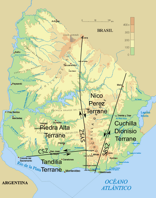
The Uruguayan dyke swarms consist of three dyke swarms of Precambrian age that intrude Río de la Plata Craton and Brasiliano Cycle continental crust in Uruguay. The dykes – including the Florida dyke swarm, the Nico Perez dyke swarm, and the Treinta y Tres dyke swarm – are of mafic to intermediate composition and each group lies in a separate tectono-stratigraphic terrane. The rocks of the Florida dyke swarm have been quarried since the 1960s and are used in the construction industry as black dimension stone of very high quality, being marketed as "black granite".
Tonalite–trondhjemite–granodiorite (TTG) rocks are intrusive rocks with typical granitic composition but containing only a small portion of potassium feldspar. Tonalite, trondhjemite, and granodiorite often occur together in geological records, indicating similar petrogenetic processes. Post Archean TTG rocks are present in arc-related batholiths, as well as in ophiolites, while Archean TTG rocks are major components of Archean cratons.
The geology of Ecuador includes ancient Precambrian basement rock and a complex tectonic assembly of new sections of crust from formerly separate landmasses, often uplifted as the Andes or transformed into basins.

The geology of Peru includes ancient Proterozoic rocks, Paleozoic and Mesozoic volcanic and sedimentary rocks, and numerous basins and the Andes Mountains formed in the Cenozoic.
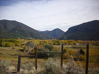
The Latir volcanic field is a large volcanic field near Questa, New Mexico, that was active during the late Oligocene to early Miocene, 28 to 22 million years ago (Ma). It includes the Questa caldera, in whose deeply eroded interior is located the Molycorp Questa molybdenum mine.
Appinite is an amphibole-rich plutonic rock of high geochemical variability. Appinites are therefore regarded as a rock series comprising hornblendites, meladiorites, diorites, but also granodiorites and granites. Appinites have formed from magmas very rich in water. They occur in very different geological environments. The ultimate source region of these peculiar rocks is the upper mantle, which was altered metasomatically and geochemically before melting.
References
- ↑ Petford, Nick; Atherton, Michael (1996). "Na-rich Partial Melts from Newly Underplated Basaltic Crust: the Cordillera Blanca Batholith, Peru". Journal of Petrology . 37 (6): 1491–1521. doi: 10.1093/petrology/37.6.1491 .
