Dotson Family Marsh

Last updated
Dotson Family Marsh (formerly Breuner Marsh) -- San Pablo Bay and shoreline vegetation in 2008. Breuner Marsh.jpg
Dotson Family Marsh (formerly Breuner Marsh) — San Pablo Bay and shoreline vegetation in 2008.

The Dotson Family Marsh, formerly Breuner Marsh, is a 238-acre (96 ha) [1] [2] [3] regional park on San Pablo Bay in the East San Francisco Bay Area city of Richmond, California, In 2009 the East Bay Regional Parks District acquired the Breuner Marsh site, adding it to Point Pinole Regional Shoreline. A habitat restoration plan for 60 acres of wetlands and 90 acres of California coastal prairie was subsequently approved. [4] [5]

Contents

On April 22, 2017, the district renamed Breuner Marsh as the Dotson Family Marsh, honoring a local family that had worked for many years to keep Breuner Marsh wild and open to the public. [6]

Geography

The boundaries surrounding Dotson Family Marsh are approximately:

History

The former Breuner Marsh land was owned by Fred Parr in the mid 20th-century. It was/is located between the bay and Parchester Village, [3] a post-WW II master planned community that was the first in the state to sell to African Americans. It was built by Parr with the promise of maintaining the marsh free from development. [8] However, Parr subsequently sold it off, leaving the community's open space in uncertainty.

Gerald Breuner

The new owner was Gerald Breuner, the owner of the former Breuners Home Furnishings chain. During the 1970s he had much of the wetlands illegally destroyed, with the intention of building a private general aviation airport, to be called Breuner Field. [3] However community and political opposition prohibited it, [9] and the small model plane airfield was the largest he could build, and some of the mixed wetlands—grasslands still remained. In the 1980s Bruener tested experimental aircraft, a gyrocopter, at the site, and used it as his primary residence. [10]

Breuner Field or Breuner Airfield was a 5-acre (2 ha) private radio controlled aircraft airfield or "flying field" and club built in the 1970s. [3] [7] [11] [12] It was located on the illegally reclaimed wetlands, at 4114 Goodrick Avenue, and was accessible from the Richmond Parkway. The site had a sports club, some cottages, and a fishing pier. The runway was about 300 ft (91 m) and is marked with x's to state that it is not suitable for landing by any planes. [13] It was run by the Bay Area Radio Control Society. [14]

Bay Area Wetlands LLC

Breuner Marsh was purchased in 2000 by Bay Area Wetlands LLC, a company that planned on selling the land to the highest bidding developer. [3] After the purchase by Bay Area Wetlands LLC, various proposals to develop the marsh were put forward. These included upscale housing, an industrial complex, a mixed use transit village with housing businesses, and a transit center, and expansion of Point Pinole Regional Shoreline, with Breuner Marsh being restored. The latter was the preferred option from the Parchester Village Neighborhood Council which had fought development in the past. [3] Development was also fought by the Sierra Club and the North Richmond Shoreline Open Space Alliance, [3] and by Gayle McLaughlin and the East Bay Regional Parks District.

The East Bay Regional Parks District had considered using Eminent Domain to prevent development of the rare undeveloped San Francisco Bay shoreline and to protect endangered species. [3] [8] Bay Area Wetlands LLC at one point wanted to build "Edgewater Technology Park" but were rebuffed by Parchester residents. [3]

Signature Homes, a housing construction firm, bought a six-month option at one point, but was unable to persuade the city council to rezone the area from light industrial, since the city wanted revenue building commercial development instead of funds-draining housing that would place addition strain on city services. [3] The city was willing to zone 27 acres (11 ha) for residential but no more. [15]

A lawsuit was filed against the property owners to protect the open space, and the court's preliminary judgment was reached on March 28, 2008. [15] The jury decided that the value of the 217 acres (0.88 km2) was $6.85 million. This was contrary to the East Bay Regional Parks District's appraiser whom valued it at $1.5 million, and the previous purchase price the Breuners received of $3 million. [15] The defendant owners argued that the city would make up to $18 million off the 27 acres (110,000 m2) where development would be allowed. [15] The owners were allowed to keep 20 acres (8 ha), but appealed the March 2008 decision nonetheless. A sale was finally reached two months later for the undeveloped property. [15]

Parkland

Threatened wildlife species in the area include the white-tailed kite, a state "Species of Concern," and endangered species such as the salt marsh harvest mouse and the California clapper rail. [16]

The East Bay Regional Park District purchased a large portion of the historic Breuner Marsh in May 2008 for $8,830,155. [17] The Park District has approved plans to restore tidal wetlands and coastal prairie habitats on the property. In addition the district planned to add a component of the San Francisco Bay Trail. [18] In 2011, EBRPD acquired Breuner Marsh, using $6,875,000 of its own bond funds. The San Francisco Bay Area Conservancy (SFBAC) joined the EBRPD effort, authorizing $1,250,000 of Conservancy funds plus a $920,000 grant from the state Fish & Wildlife Agency. [19] [lower-alpha 1]

On April 22, 2017, the district renamed Breuner Marsh as the Dotson Family Marsh, honoring a local family that had worked for many years to keep Breuner Marsh wild and open to the public, while opposing several attempts to develop the tract for commercial ventures. [6]

Notes

  1. SFBAC had previously worked on other restoration projects for the north Richmond shoreline area, including the Richmond Parkway Shoreline Pollution Mitigation Plan in 1995, a Rheem Creek Watershed Assessment and Conceptual Restoration Plan in 2007, and a North Richmond Shoreline Conservation Plan in March 2010. [19]

See also

Related Research Articles

<span class="mw-page-title-main">San Francisco Bay</span> Shallow estuary on the coast of California, United States

San Francisco Bay is a large tidal estuary in the U.S. state of California, and gives its name to the San Francisco Bay Area. It is dominated by the cities of San Francisco, San Jose, and Oakland.

<span class="mw-page-title-main">East Bay Regional Park District</span> Special district in California, US

The East Bay Regional Park District (EBRPD) is a special district operating in Alameda County and Contra Costa County, California, within the East Bay area of the San Francisco Bay Area. It maintains and operates a system of regional parks which is the largest urban regional park district in the United States. The administrative office is located in Oakland.

<span class="mw-page-title-main">Point Pinole Regional Shoreline</span> Regional park in San Pablo Bay, California

Point Pinole Regional Shoreline is a regional park on the shores of the San Pablo Bay, California, in the United States. It is approximately 2,315 acres (9.37 km2) in area, and is operated by the East Bay Regional Park District. It includes the Dotson Family Marsh and the Point Pinole Lagoon and hosts the North Richmond Shoreline Festival.

<span class="mw-page-title-main">Brooks Island Regional Preserve</span> Island in the United States of America

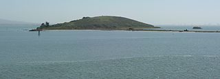
Brooks Island Regional Preserve includes both the 75-acre (30 ha) of Brooks Island above the low-tide line and 300 acres (120 ha) of the surrounding bay. The only public access to the island is via an East Bay Regional Park District naturalist tour.

<span class="mw-page-title-main">Parchester Village, Richmond, California</span>

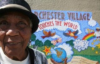
Parchester Village is a planned majority African-American village in northwestern Richmond, California that was the first in the state to sell to blacks.

<span class="mw-page-title-main">McLaughlin Eastshore State Park</span> State park and wildlife refuge

McLaughlin Eastshore State Park is a state park and wildlife refuge along the San Francisco Bay shoreline of the East Bay between the cities of Richmond, Albany, Berkeley, Emeryville, and Oakland. It encompasses remnant natural wetlands, restored wetlands, as well as landfill west of the Eastshore Freeway. Its shoreline is 8.5 miles (13.7 km) long, and its total area is 1,854 acres (750 ha), which includes both tidelands and uplands. Originally named just Eastshore State Park, it was renamed in October 2012 to honor the late Save the Bay founder Sylvia McLaughlin, who, along with the late Dwight Steele of Citizens for Eastshore Park, drove the establishment of the park. Prior to 2013, it was jointly managed by the California State Parks and East Bay Regional Park District (EBRPD). The state agency and EBRPD executed a 30-year agreement for EBRPD to manage the park.

<span class="mw-page-title-main">Point Isabel Regional Shoreline</span> Multi-use park

Point Isabel Regional Shoreline in Richmond, California, is operated by East Bay Regional Park District, and is a multi-use park for joggers, windsurfers, kayakers, photographers, picnickers, and people walking dogs. It has access for pedestrians and via public transit, private vehicles, and bikes. It also features a concession offering food for people and grooming for pets. A longtime community organization and nonprofit, Point Isabel Dog Owners and Friends (PIDO), is active in the maintenance and improvement of the park.

<span class="mw-page-title-main">Middle Harbor Shoreline Park</span>

Middle Harbor Shoreline Park (MHSP) is located on San Francisco Bay and the Port of Oakland entrance channel, west of downtown Oakland, California. It is owned and operated by the Port of Oakland. The park entrance is at the intersection of 7th Street and Middle Harbor Road. It is open seven days a week from 8 a.m. to dusk.

<span class="mw-page-title-main">Briones Regional Park</span>

Briones Regional Park is a 6,117-acre (24.75 km2) regional park in the East Bay Regional Park District (EBRPD) system, located in the Briones Hills of central Contra Costa County of the San Francisco Bay Area in California.

<span class="mw-page-title-main">Carquinez Strait Regional Shoreline</span> Regional park in California, US

Carquinez Strait Regional Shoreline is a regional park, part of the East Bay Regional Park District system, located in northwestern Contra Costa County, California.

<span class="mw-page-title-main">Radke Martinez Regional Shoreline</span>

Radke Martinez Regional Shoreline (RMRS) is a regional park on the shoreline of Carquinez Strait in Martinez, located in northern Contra Costa County, California. Formerly known as the Martinez Regional Shoreline, it was renamed on December 6, 2016, in honor of the late Ted Radke and his late wife Kathy Radke.

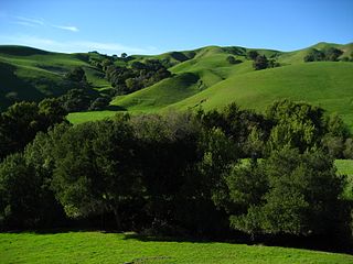
Morgan Territory Regional Preserve is a regional park in Contra Costa County, California. Located east of Clayton and north of Livermore, California, bordering on Mt. Diablo State Park, it is part of the East Bay Regional Park District (EBRPD). The preserve was founded in 1975 with fewer than 1,000 acres (400 ha), but EBRPD has gradually acquired more property, and, since 2015, the preserve encompasses 5,230 acres (2,120 ha). The main access roads run from Livermore and Clayton.

Sobrante Ridge Regional Preserve (SRRP) is a regional park in Richmond, Contra Costa County, California and is part of the East Bay Regional Parks (EBRPD) system. The park preserves one of the few habitats of the Alameda manzanita, which is deemed extremely rare, according to EBRPD.

Waterbird Regional Preserve is a 192 acres (0.78 km2) regional park located in Contra Costa County, California, adjacent to the city of Martinez. It is part of the East Bay Regional Park District (EBRPD). It primarily consists of an area known as McNabney Marsh, which lies alongside Interstate 680 near the Sacramento-San Joaquin Delta and between two large and active oil refineries. The marsh drains into Suisun Bay via Peyton Slough. The area provides habitat for a wide variety of waterfowl and shorebirds for resting and feeding.

Stege Marsh, also known as the South Richmond Marshes, is a tidal marshland wetlands area in Richmond, California in western Contra Costa County.

Hoffman Marsh is a wetlands on San Francisco Bay in Richmond, California. The marsh has been protected within Eastshore State Park, and adjacent to Point Isabel Regional Shoreline. The marsh is an important nesting ground for wildfowl and stopping ground on the Pacific Flyway, as it is one of only a handful of undestroyed wetlands in the Bay Area. It borders Point Isabel Regional Shoreline and Interstate 80.

<span class="mw-page-title-main">Pinole Creek</span> River in California, United States

Pinole Creek is a stream in western Contra Costa County, in the East Bay region of the San Francisco Bay Area, California.

Citizens for East Shore Parks (CESP) is a United States environmental organization that focuses on the acquisition and preservation of parkland in the San Francisco Bay Area. CESP works to protect open space along the East Bay shoreline for natural habitat and recreational purposes through a combination of advocacy, education, and outreach. Since its founding in 1985, CESP has worked to secure approximately 1,800 acres (730 ha) of public land, primarily through the creation of the 8.5-mile (13.7 km) long Eastshore State Park in 2002.

Chelsea Wetlands is a riparian marsh on lower Pinole Creek and a tidal wetland at its mouth on San Pablo Bay, in Contra Costa County, northern California. It is located within the city of Hercules, in the East Bay region of the San Francisco Bay Area.

<span class="mw-page-title-main">Oyster Bay Regional Shoreline</span> Park in San Leandro, California

Oyster Bay Regional Shoreline is a park in San Leandro, California, part of the East Bay Regional Park District (EBRPD). It is located along the eastern shore of San Francisco Bay directly to the south of Oakland International Airport. The property was originally used as a landfill for 37 years, until it was filled to capacity in 1977, when it was capped with a clay cover. EBRPD bought the property in 1980, intending to use it as a park.

References

37°58′56″N122°21′46″W / 37.98227°N 122.362697°W / 37.98227; -122.362697

  1. North Richmond's Wetlands Threatened by Development Archived May 17, 2008, at the Wayback Machine , Pacific Institute, access date August 8, 2008
  2. Breuner Marsh Stewardship, by Aleta George, Bay Nature, March 2006, access date August 8, 2008
  3. 1 2 3 4 5 6 7 8 9 10 Parchester Village Residents Fight to Preserve Breuner Marsh, Open Space, by Tomio Geron, November 12, 2004, access date August 8, 2008
  4. EBRPD: Breuner Marsh Project - Fact Sheet Archived 2012-10-27 at the Wayback Machine . accessed 1.13.2013
  5. EBRPD: Breuner Marsh Restoration & Public Access Project — pdf index Archived 2013-01-17 at the Wayback Machine . accessed 1.13.2013
  6. 1 2 "Point Pinole Regional Shoreline." East Bay Regional Parks System. Accessed August 29, 2017.
  7. 1 2 San Francisco Bay Area Wetlands Restoration Program Archived November 11, 2010, at the Wayback Machine , Letter of Review/Breuner Marsh Mitigation Bank, January 28, 2003, access date August 8, 2008
  8. 1 2 Park District may save Breuner Marsh, Archived December 2, 2008, at the Wayback Machine Sierra Club Yodeler, access date August 8, 2008
  9. Parchester's Marsh Archived October 24, 2007, at the Wayback Machine , by Kathryn Gillick, Ecology Center, access date August 13, 2008
  10. Collective pitch change system for teter-bar type gyroplane rotary wing aircraft, United States Patent 4741672, May 3, 1988 access date August 15, 2008
  11. About Archived March 27, 2008, at the Wayback Machine , BARCS.org, January 20, 2008, access date August 10, 2008
  12. Richmond, Gallagher & Lindsay Realtors, access date August 10, 2008
  13. Google maps, access date August 15, 2008
  14. Bay Area Radio Control Society (BARCS); remote control airplane club which operated the model plane facility
  15. 1 2 3 4 5 Breuner Marsh to become parkland at last! Archived 2008-06-26 at the Wayback Machine , Citizens for East Shore Parks, access date August 8, 2008
  16. Government report, p. 6, access date August 10, 2008
  17. "Park Board Package: Breuner Marsh" (PDF). Archived from the original (PDF) on 2011-11-29. Retrieved 2011-10-27.
  18. "EBParks News Archive". Archived from the original on 2010-04-23. Retrieved 2010-04-09.
  19. 1 2 Breuner Marsh Restoration Project. San Francisco Bay Area Conservancy. August 2, 2012. Accessed July 25, 2018.