EROS A

Last updated

EROS A
NamesEarth Remote Observation System-A
EROS-A1
Mission type Earth observation
Operator ImageSat International
COSPAR ID 2000-079A OOjs UI icon edit-ltr-progressive.svg
SATCAT no. 26631
Website https://www.imagesatintl.com/
Mission duration10 years (planned)
16.5 years (achieved)
Spacecraft properties
SpacecraftEROS-A1
Spacecraft typeOfeq-3
Bus OPSAT-2000 [1]
Manufacturer Israel Aerospace Industries
Launch mass260 kg (570 lb)
Dimensions2.3 m in height
1.2 m in diameter
Power450 watts
Start of mission
Launch date5 December 2000, 12:32 UTC [2]
Rocket Start-1
Launch site Svobodny Cosmodrome,
Launch Complex-5
Contractor Moscow Institute of Thermal Technology
End of mission
Last contactMay 2016 [3]
Decay date7 July 2016 [4]
Orbital parameters
Reference system Geocentric orbit [5]
Regime Low Earth orbit
Perigee altitude 490 km (300 mi)
Apogee altitude 565 km (351 mi)
Inclination 97.30°
Period 94.60 minutes
EROS-B  
 

The Earth Remote Observation System-A (EROS-A or EROS-A1) was part of the EROS family of Israeli commercial Earth observation satellites, designed and manufactured by Israel Aircraft Industries (IAI). [6] This was the first satellite in the series. The satellite was owned and operated by ImageSat International, ImageSat International N.V. (ISI) headquartered at Limassol, Cyprus, and incorporated in the Netherlands Antilles, Cayman Islands. [7]

Contents

Launch

The EROS A was launched on 5 December 2000, at 12:32 UTC, [2] from Svobodny Cosmodrome, Launch Complex-5 in eastern Siberia. [7]

Satellite description

The satellite was 1.2 m in diameter, 2.3 m in height. It weighed 260 kg at launch. [7] The design was based on the military reconnaissance satellite Ofeq-3, which was previously built, also by Israel Aerospace Industries (IAI) for Israeli government use.

Control systems

The satellite was equipped with a three-axis stabilized and a four reaction wheels actuator. The satellite is also equipped with horizon sensors, Sun sensors, gyroscopes and magnetometer for altitude determination. [3]

Ground communication systems

The satellite is equipped with a 70  Mbit/s imagery link, a 15  kbit/s maintenance downlink, and a 15 kbit/s command uplink. [8]

Mission

The satellite always crosses the equator at 10:00 am local time. Future satellites were planned to extend the time dimension to vary the crossing time between mid-morning and mid after. This will allow it to compensate for poor visibility conditions arising from clouds at different altitudes. While the satellite's primary purpose is agricultural engineers, planners and other professionals who need detailed pictures of different places in the world, it can also be used for various other applications. The satellite provides commercial images with an optical resolution of 1.8 metres using. It has optical resolution capabilities of up to 1.2 meters. The satellite can be temporarily controlled by a customer when it passes over the areas of interest. This is used to allow the client privacy without the operator knowing what's being looked at. This capability, however, is not allowed over the State of Israel by the Israeli government.

Following its launch, the first customer announced was the Ministry of Defense of Israel, which paid about $15 million for the exclusive rights to receive all images of Israel's territory and an area within a radius of about 2,000 km. The need for the satellite's capabilities was due to the failure of the launch of the Ofek-4 satellite, two years earlier and the decay of Ofek-3. [9] [10] Other customers of the satellite were the Taiwan Defense Ministry, [11] India, [12] and media organizations that purchased footage from the battlefield at the start of the Afghan war, footage that competitor "Space Imaging" (Owner of Ikonos) was banned from selling by the US government. [13] Additionally, a database was established with photographs of the satellite that were sold to companies around the world on demand. [14]

The satellite increased its orbital altitude for the last time on 24 April 2012 and reentered on 7 July 2016. [1]

See also

Related Research Articles

<span class="mw-page-title-main">Earth observation satellite</span> Satellite specifically designed to observe Earth from orbit

An Earth observation satellite or Earth remote sensing satellite is a satellite used or designed for Earth observation (EO) from orbit, including spy satellites and similar ones intended for non-military uses such as environmental monitoring, meteorology, cartography and others. The most common type are Earth imaging satellites, that take satellite images, analogous to aerial photographs; some EO satellites may perform remote sensing without forming pictures, such as in GNSS radio occultation.

<span class="mw-page-title-main">Israel Aerospace Industries</span> Aerospace and defense manufacturer

Israel Aerospace Industries or IAI (תע"א) is Israel's major aerospace and aviation manufacturer, producing aerial and astronautic systems for both military and civilian usage. It has 15,000 employees as of 2018. IAI is state-owned by the government of Israel.

<span class="mw-page-title-main">Satellite imagery</span> Images taken from an artificial satellite

Satellite images are images of Earth collected by imaging satellites operated by governments and businesses around the world. Satellite imaging companies sell images by licensing them to governments and businesses such as Apple Maps and Google Maps.

<span class="mw-page-title-main">Ofeq</span> Israeli reconnaissance satellites

Ofeq, also spelled Offek or Ofek is the designation of a series of Israeli reconnaissance satellites first launched in 1988. Most Ofeq satellites have been carried on top of Shavit 2 launch vehicles from Palmachim Airbase in Israel, on the Mediterranean coast. The low Earth orbit satellites complete one Earth orbit every 90 minutes. The satellite launches made Israel the eighth nation to gain an indigenous launch capability. Both the satellites and the launchers were designed and manufactured by Israel Aerospace Industries (IAI) with Elbit Systems' El-Op division supplying the optical payload.

<span class="mw-page-title-main">EROS (satellite)</span> Israeli commercial Earth observation satellite series

Earth Resources Observation Satellite (EROS) is a series of Israeli commercial Earth observation satellites, designed and manufactured by Israel Aircraft Industries (IAI), with optical payload supplied by El-Op. The satellites are owned and operated by ImageSat International N.V. (ISI), a company founded in 1997, as a Joint venture between IAI, El-Op and Core Software Technology (CST). EROS A was launched on December 5, 2000 and EROS B on April 25, 2006.

<span class="mw-page-title-main">Israel Space Agency</span> Government space agency of Israel

The Israel Space Agency is a governmental body, a part of Israel's Ministry of Science and Technology, that coordinates all Israeli space research programs with scientific and commercial goals.

<span class="mw-page-title-main">Ofeq-7</span> Israeli reconnaissance satellite

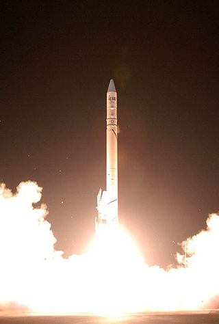
Ofeq-7 is part of the Ofeq family of Earth observation satellites designed and built by Israel Aerospace Industries (IAI) for the Israel Ministry of Defense.

<span class="mw-page-title-main">RISAT</span> Series of Indian radar imaging satellites

RISAT (Radar Imaging Satellite) is a series of Indian radar imaging reconnaissance satellites built by the Indian Space Research Organization (ISRO). They provide all-weather surveillance using synthetic aperture radars (SAR).

Ofeq-9, also known as Ofek 9, is part of the Ofeq family of reconnaissance satellites designed and built by Israel Aerospace Industries (IAI) for the Israeli Ministry of Defense.

<span class="mw-page-title-main">EROS B</span> Israeli commercial Earth observation satellite

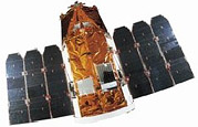
The Earth Remote Observation System-B (EROS-B) is the second satellite launched in a series of the EROS family of Israeli commercial Earth observation satellites, designed and manufactured by Israel Aircraft Industries (IAI). It is owned and operated by ImageSat International N.V. (ISI), in the Netherlands Antilles, Cayman Islands, with offices in Limassol, Cyprus, and in Tel Aviv, Israel.

<span class="mw-page-title-main">VENµS</span>

Vegetation and Environment monitoring on a New Micro-Satellite (VENµS) is a near polar Sun-synchronous orbit microsatellite. It is a joint project of the Israeli Space Agency and CNES. The project was signed upon in April 2005 and was launched on the 2nd of August 2017. The microsatellite, which was set to cost the ISA US$20 million and CNES €10 million, was designed and built by IAI and Rafael under ISA's supervision.

<span class="mw-page-title-main">Planet Labs</span> American company specializing in satellite imaging of Earth

Planet Labs PBC is an American public Earth imaging company based in San Francisco, California. Their goal is to image the entirety of the Earth daily to monitor changes and pinpoint trends.

Ofeq-10, also known as Ofek-10, is part of the Ofeq family of reconnaissance satellites designed and built by Israel Aerospace Industries (IAI) for the Israeli Ministry of Defense.

Satellogic is a company specializing in Earth-observation satellites, founded in 2010 by Emiliano Kargieman and Gerardo Richarte.

<span class="mw-page-title-main">PSLV-C37</span> 39th mission of the PSLV space-rocket program

PSLV-C37 was the 39th mission of the Indian Polar Satellite Launch Vehicle (PSLV) program and its 16th mission in the XL configuration undertaken by the Indian Space Research Organisation (ISRO). Launched on 15 February 2017 from the Satish Dhawan Space Centre at Sriharikota, Andhra Pradesh, the rocket successfully carried and deployed a record number of 104 satellites in Sun-synchronous orbits in a single mission, breaking the earlier record of launching 37 satellites by a Russian Dnepr rocket on 19 June 2014. This record was held until the launch of the Transporter-1 mission by SpaceX on 24 January 2021 which launched 143 satellites.

<span class="mw-page-title-main">BGUSAT</span>

BGUSAT was an Israeli research CubeSat built by the IAI and Ben Gurion University.

<span class="mw-page-title-main">Capella Space</span> American space company

Capella Space is an American space company. It is developing space-based radar Earth observation satellites equipped with synthetic-aperture radar that can penetrate clouds and work at night. The company is based in San Francisco, California. It was founded by Payam Banazadeh, a former engineer at Jet Propulsion Laboratory of NASA, and William Walter Woods.

AMOS-8 was a planned Israeli communications satellite, one of the Spacecom AMOS series, to be built by Maxar Technologies, a US defense and aerospace company, to replace AMOS-3 and AMOS-7

Ofek-16, also known as Ofeq-16, is an Israeli electro-optical reconnaissance satellite. It is part of the Ofeq family, designed and built by Israel Aerospace Industries (IAI) for the Israeli Ministry of Defence.

<span class="mw-page-title-main">OPTSAT-3000</span> Italian Earth-observation and reconnaissance satellite

OPTSAT-3000, or SHALOM is an Italian Earth observation and reconnaissance satellite developed and built by Israel Aerospace Industries and operated by the Italian Ministry of Defence. Launched on August 2, 2017, it has an expected service life of at least 7 years. It is based on the design of the TecSAR-1 satellite.

References

  1. 1 2 "EROS-A1, A2". Gunter's Space Page. 7 July 2020. Retrieved 9 May 2021.
  2. 1 2 "Launch Log". Jonathan's Space Report. 14 March 2021. Retrieved 9 May 2021.
  3. 1 2 "EROS A". Apollo Mapping. Retrieved 9 May 2021.
  4. Peat, Chris (21 November 2013). "EROS-A1 - Orbite". Heavens Above. Retrieved 9 May 2021.
  5. "Trajectory:EROS-A1 2000-079A". NASA. 27 April 2021. Retrieved 9 May 2021.PD-icon.svg This article incorporates text from this source, which is in the public domain .
  6. "Serbia Settlement IAI Bond Purchase Boost Fortunes of Israel's ImageSat". SpaceNews. 28 January 2011. Retrieved 9 May 2021.
  7. 1 2 3 "EROS-A (Earth Remote Observation System-A)". ESA Earth Observation Portal. Retrieved 9 May 2021.
  8. A., Klein (16–20 September 1996). "Flight Operations Engineering for the Earth Resource Spacecraft EROS-A". Space Mission Operations and Ground Data Systems - Spaceops '96. NASA. 394: 1051. Bibcode:1996ESASP.394.1051K . Retrieved 9 May 2021.PD-icon.svg This article incorporates text from this source, which is in the public domain .
  9. Barzilai, Amnon (27 May 2002). "Launch of Ofek 5 Satellite Due Soon". Haaretz .
  10. Marom, Dror (2 February 2003). "Not the end of Israel in space". Globes . Retrieved 5 May 2022.
  11. Barzilai, Amnon (15 August 2001). "Pictures for Taiwan Irk China". Haaretz .
  12. Dagoni, Ran (25 September 2003). "India seeks pictures from Israeli Ofek 5 spy satellite". Globes .
  13. Dagoni, Ran (23 October 2001). "ImageSat International selling satellite photos of Afghanistan bombing". Globes . Retrieved 5 May 2022.
  14. Marom, Dror (23 July 2001). "ImageSat starts marketing satellite services over six months after launch". Globes . Retrieved 4 May 2022.