The Holocene is the current geological epoch, beginning approximately 11,700 years ago. It follows the Last Glacial Period, which concluded with the Holocene glacial retreat. The Holocene and the preceding Pleistocene together form the Quaternary period. The Holocene is an interglacial period within the ongoing glacial cycles of the Quaternary, and is equivalent to Marine Isotope Stage 1.

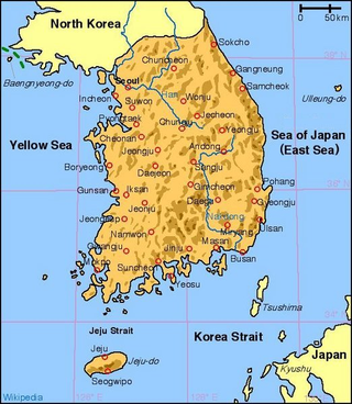
South Korea is located in East Asia, on the southern portion of the Korean Peninsula located out from the far east of the Asian landmass. The only country with a land border to South Korea is North Korea, lying to the north with 238 kilometres (148 mi) of the border running along the Korean Demilitarized Zone. South Korea is mostly surrounded by water and has 2,413 kilometres (1,499 mi) of coast line along three seas; to the west is the Yellow Sea, to the south is the East China Sea, and to the east is the Sea of Japan. Geographically, South Korea's landmass is approximately 100,032 square kilometres (38,623 sq mi). 290 square kilometres (110 sq mi) of South Korea are occupied by water. The approximate coordinates are 37° North, 128° East.
The Younger Dryas, which occurred circa 12,900 to 11,700 years BP, was a return to glacial conditions which temporarily reversed the gradual climatic warming after the Last Glacial Maximum, which lasted from circa 27,000 to 20,000 years BP. The Younger Dryas was the last stage of the Pleistocene epoch that spanned from 2,580,000 to 11,700 years BP and it preceded the current, warmer Holocene epoch. The Younger Dryas was the most severe and longest lasting of several interruptions to the warming of the Earth's climate, and it was preceded by the Late Glacial Interstadial, an interval of relative warmth that lasted from 14,670 to 12,900 BP.

A monsoon is traditionally a seasonal reversing wind accompanied by corresponding changes in precipitation but is now used to describe seasonal changes in atmospheric circulation and precipitation associated with annual latitudinal oscillation of the Intertropical Convergence Zone (ITCZ) between its limits to the north and south of the equator. Usually, the term monsoon is used to refer to the rainy phase of a seasonally changing pattern, although technically there is also a dry phase. The term is also sometimes used to describe locally heavy but short-term rains.

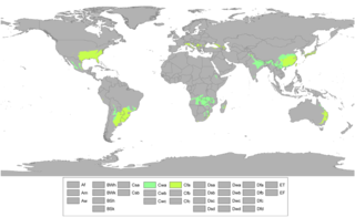
The Köppen climate classification is one of the most widely used climate classification systems. It was first published by German-Russian climatologist Wladimir Köppen (1846–1940) in 1884, with several later modifications by Köppen, notably in 1918 and 1936. Later, German climatologist Rudolf Geiger (1894–1981) introduced some changes to the classification system in 1954 and 1961, which is thus sometimes called the Köppen–Geiger climate classification.

The Last Glacial Maximum (LGM), also referred to as the Last Glacial Coldest Period, was the most recent time during the Last Glacial Period where ice sheets were at their greatest extent 26,000 and 20,000 years ago. Ice sheets covered much of Northern North America, Northern Europe, and Asia and profoundly affected Earth's climate by causing a major expansion of deserts, along with a large drop in sea levels.
The Holocene Climate Optimum (HCO) was a warm period in the first half of the Holocene epoch, that occurred in the interval roughly 9,500 to 5,500 years BP, with a thermal maximum around 8000 years BP. It has also been known by many other names, such as Altithermal, Climatic Optimum, Holocene Megathermal, Holocene Optimum, Holocene Thermal Maximum, Hypsithermal, and Mid-Holocene Warm Period.

The East Asian rainy season, also called the plum rain, is caused by precipitation along a persistent stationary front known as the Meiyu front for nearly two months during the late spring and early summer in East Asia between mainland China, Taiwan, Korea and Japan. The wet season ends during the summer when the subtropical ridge becomes strong enough to push this front north of the region. These weather systems can produce heavy rainfall and flooding.

The 4.2-kiloyear BP aridification event, also known as the 4.2 ka event, was one of the most severe climatic events of the Holocene epoch. It defines the beginning of the current Meghalayan age in the Holocene epoch.

In climatology, the 8.2-kiloyear event was a sudden decrease in global temperatures that occurred approximately 8,200 years before the present, or c. 6,200 BC, and which lasted for the next two to four centuries. It defines the start of the Northgrippian age in the Holocene epoch. The cooling was significantly less pronounced than during the Younger Dryas cold period that preceded the beginning of the Holocene. During the event, atmospheric methane concentration decreased by 80 ppb, an emission reduction of 15%, by cooling and drying at a hemispheric scale.

Owing to tremendous differences in latitude, longitude, and altitude, the climate of China is extremely diverse. It ranges from tropical in the far south to subarctic in the far north, and alpine in the higher elevations of the Tibetan Plateau. Monsoon winds, caused by differences in the heat-absorbing capacity of the continent and the ocean, dominate the climate. During the summer, the East Asian Monsoon carries warm and moist air from the south and delivers the vast majority of the annual precipitation in much of the country. Conversely, the Siberian anticyclone dominates during winter, bringing cold and comparatively dry conditions. The advance and retreat of the monsoons account, in large degree, for the timing of the rainy season throughout the country. Although most of the country lies in the temperate belt, its climatic patterns are complex.

Most regions of Japan, such as Honshu, Shikoku, and Kyushu, belong to the temperate zone with humid subtropical climate characterized by four distinct seasons. However, its climate varies from cool humid continental climate in the north such as northern Hokkaido, to warm tropical rainforest climate in the south such as the Yaeyama Islands and Minami-Tori-shima.
The Subatlantic is the current climatic age of the Holocene epoch. It started about 2,500 years BP and is still ongoing. Its average temperatures are slightly lower than during the preceding Subboreal and Atlantic. During its course, the temperature underwent several oscillations, which had a strong influence on fauna and flora and thus indirectly on the evolution of human civilizations. With intensifying industrialisation, human society started to stress the natural climatic cycles with increased greenhouse gas emissions.

A humid subtropical climate is a temperate climate type characterized by hot and humid summers, and cool to mild winters. These climates normally lie on the southeast side of all continents, generally between latitudes 25° and 40° and are located poleward from adjacent tropical climates, and equatorward from either humid continental or oceanic climates. It is also known as warm temperate climate in some climate classifications.

The climate of Asia is dry across its southwestern region. Some of the largest daily temperature ranges on Earth occur in the western part of Asia. The monsoon circulation dominates across the southern and eastern regions, due to the Himalayas forcing the formation of a thermal low which draws in moisture during the summer. The southwestern region of the continent experiences low relief as a result of the subtropical high pressure belt; they are hot in summer, warm to cool in winter, and may snow at higher altitudes. Siberia is one of the coldest places in the Northern Hemisphere, and can act as a source of arctic air mass for North America. The most active place on Earth for tropical cyclone activity lies northeast of the Philippines and south of Japan, and the phase of the El Nino-Southern Oscillation modulates where in Asia landfall is more likely to occur. Many parts of Asia are being impacted by climate change.

Zhuye Lake is the terminal lake of the Shiyang River, which is located in the east of the Hexi Corridor in Gansu Province, China. Zhuye Lake is located in the marginal area of the Asian monsoon and is affected by both the Asian monsoon system and the Westerly jet. By understanding the Holocene record in Zhuye Lake, the interaction of different climate systems during the Holocene can be studied. At the same time, the Asian monsoon system is climatically dynamic; changes in its sphere of influence can result in severe drought or flood over large, densely populated, regions. In addition, Zhuye Lake and the surrounding area in arid NW China are in ecological imbalance – a consequence of human impacts and climate. Understanding the environmental history here can assist climatological forecasting of the Asian monsoon system and ecosystem reconstruction.

The African humid period is a climate period in Africa during the late Pleistocene and Holocene geologic epochs, when northern Africa was wetter than today. The covering of much of the Sahara desert by grasses, trees and lakes was caused by changes in the Earth's axial tilt; changes in vegetation and dust in the Sahara which strengthened the African monsoon; and increased greenhouse gases. During the preceding Last Glacial Maximum, the Sahara contained extensive dune fields and was mostly uninhabited. It was much larger than today, and its lakes and rivers such as Lake Victoria and the White Nile were either dry or at low levels. The humid period began about 14,600–14,500 years ago at the end of Heinrich event 1, simultaneously to the Bølling–Allerød warming. Rivers and lakes such as Lake Chad formed or expanded, glaciers grew on Mount Kilimanjaro and the Sahara retreated. Two major dry fluctuations occurred; during the Younger Dryas and the short 8.2 kiloyear event. The African humid period ended 6,000–5,000 years ago during the Piora Oscillation cold period. While some evidence points to an end 5,500 years ago, in the Sahel, Arabia and East Africa, the end of the period appears to have taken place in several steps, such as the 4.2-kiloyear event.

The Medieval Warm Period (MWP), also known as the Medieval Climate Optimum or the Medieval Climatic Anomaly, was a time of warm climate in the North Atlantic region that lasted from c. 950 to c. 1250. Climate proxy records show peak warmth occurred at different times for different regions, which indicate that the MWP was not a globally uniform event. Some refer to the MWP as the Medieval Climatic Anomaly to emphasize that climatic effects other than temperature were also important.

Lake Estancia was a lake formed in the Estancia Valley, central New Mexico, which left various coastal landforms in the valley. The lake was mostly fed by creek and groundwater from the Manzano Mountains, and fluctuated between freshwater stages and saltier stages. The lake had a diverse fauna, including cutthroat trout; they may have reached it during a possible past stage where it was overflowing.
Weijian Zhou is a geologist at the Chinese Academy of Sciences known for her research into environmental changes in the Quaternary era using radiocarbon data.


