East Central Minnesota

Last updated
East Central Minnesota

PICKM Counties
PICKM Map.jpg
East Central Minnesota
Principle cities Cambridge, Pine City
Area
  Land3,356 sq mi (8,692 km2)
  Water188.0 sq mi (486.9 km2)
Population
(2016)
  Density46.36/sq mi (17.90/km2)
  Total Population
164,343
Time zone CST
  Summer (DST) CDT

East Central Minnesota is a region in the east-central portion of the state of Minnesota, consisting of Pine County, Isanti County, Chisago County, Kanabec County and Mille Lacs County, and is also referred to as the PICKM counties. [1] [2] It is the eastern portion of Central Minnesota [3] . Major highways running through the region include Interstate 35 and U.S. Highway 169.

Minnesota State of the United States of America

Minnesota is a state in the Upper Midwest and northern regions of the United States. Minnesota was admitted as the 32nd U.S. state on May 11, 1858, created from the eastern half of the Minnesota Territory. The state has a large number of lakes, and is known by the slogan the "Land of 10,000 Lakes". Its official motto is L'Étoile du Nord.

Central Minnesota

Central Minnesota is the region consisting of the central portion of the state of Minnesota. Although no specific boundaries of the region exist, most definitions of what makes up the region would generally consist of the vast swath of land north of Interstate 94, east of U.S. Highway 59, south of U.S. Highway 2, and west of U.S. Highway 169. To the east of this region is East Central Minnesota.

Interstate 35 Interstate from Texas to Minnesota

Interstate 35 (I-35) is a major Interstate Highway in the central United States. As with most interstates that end in a five, it is a major cross-country, north-south route stretching from Laredo, Texas, at the Mexican-American border to Duluth, Minnesota, at Minnesota Highway 61 and 26th Avenue East. The highway splits into Interstate 35E and Interstate 35W in two separate places, the Dallas–Fort Worth metroplex in Texas and at the Minnesota twin cities of Minneapolis–Saint Paul.

Contents

This region has a development consortium called GPS:45:93, [4] due to its approximate GPS coordinates. [5] The region has shown strong growth throughout the past two decades, especially in Chisago County around North Branch and Wyoming. [6] A notable regional event, East-Central Minnesota Pride was first held in 2005 [7] .

North Branch, Minnesota City in Minnesota, United States

North Branch is a city in Chisago County, Minnesota, United States, located at the junction of Interstate 35 and Minnesota State Highway 95 in East Central Minnesota. The population was 10,125 at the 2010 census. It is named for the north branch of the Sunrise River, which flows through the city.

Wyoming, Minnesota City in Minnesota, United States

Wyoming is a city in Chisago County, Minnesota, United States. The population was 7,791 at the 2010 census.

East-Central Minnesota Pride

East-Central Minnesota Pride is the yearly celebration of the lesbian, gay, bisexual, and transgender (LGBT) residents in the rural area near Pine City, Minnesota. It is just one of two prides held in a rural community in the U.S. The celebration is held during the first weekend in June in Pine City, Minnesota.

Geography

Mille Lacs Lake, Mille Lacs County Mille Lacs Lake.jpg
Mille Lacs Lake, Mille Lacs County

East Central Minnesota has several notable lakes. Mille Lacs Lake, with an area of 206 mi² (534 km²), is the second largest lake entirely within Minnesota, next to Red Lake. [8] Also, the Chisago Lakes subregion is located in the southeast portion of the region. Three counties exist in this region as well as the Twin Cities 16-county metropolitan area. With the 2010 Census, Mille Lacs County was added to the Minneapolis-St. Paul metro area, along with Isanti County and Chisago County, due to the threshold of commuters from those counties traveling into the Twin Cities for work [9] .

Mille Lacs Lake lake

Mille Lacs Lake is a large but shallow lake in the U.S. state of Minnesota. It is located in the counties of Mille Lacs, Aitkin, and Crow Wing, roughly 100 miles north of the Minneapolis-St. Paul metropolitan area.

Red Lake (Minnesota) lake in Beltrami County, Minnesota, United States

Red Lake is a lake in Beltrami County in northern Minnesota.

Chisago Lakes is an area of Chisago County, Minnesota along Highway 8. The Chisago Lakes Area Chamber of Commerce includes the combined areas of Shafer, Center City, Chisago City, and Lindström.

Pine County Courthouse, Pine City. PineCountyMNcourthouse.JPG
Pine County Courthouse, Pine City.

Cities

North Branch's city limits sign featuring GreenStep Cities designation. NB pop. sign.jpg
North Branch's city limits sign featuring GreenStep Cities designation.
Cambridge, Minnesota City in Minnesota, United States

Cambridge is a city in Isanti County, Minnesota, United States, located at the junction of Minnesota State Highways 65 and 95. The population was 8,111 at the 2010 census. It is the county seat of Isanti County. It is located along the Rum River and the BNSF Railway. Cambridge is notable for having the highest percentage of Swedish Americans of any city in the United States with a population of over 5,000 people.

Isanti County, Minnesota county in Minnesota, United States

Isanti County is a county located in the U.S. state of Minnesota. As of the 2010 census, the population was 37,816. Its county seat is Cambridge. Isanti is derived from the Dakota word meaning "knife" and refers to the Santee tribe.

Center City, Minnesota City in Minnesota, United States

Center City is a city in Chisago County, Minnesota, United States. The population was 628 at the 2010 census. It is the county seat of Chisago County.

Higher education

East Central Minnesota is home to the following colleges:

Pine Technical and Community College, Pine City Pine Technical and Community College, Pine City, Minnesota (34284477943).jpg
Pine Technical and Community College, Pine City
Pine City, Minnesota City in Minnesota, United States

Pine City is a city in Pine County, Minnesota, in east central Minnesota. Pine City is also the county seat of Pine County. A portion of the city is located on the Mille Lacs Indian Reservation. Founded as a railway town, it quickly became a logging community and the surrounding lakes made it a resort town. Today, it exists in part as a commuter town to jobs in the Minneapolis–Saint Paul metropolitan area. It is also a participant in the Green Steps program by the Minnesota Pollution Control Agency.

Anoka-Ramsey Community College is a public community college in Cambridge and Coon Rapids, Minnesota. Founded in 1965, the college annually serves more than 12,500 students as they pursue associate degrees that transfer as the first two years of a bachelor's degree, as well as certificate programs. Anoka-Ramsey Community College is a member of the Minnesota State Colleges and Universities System. The college also focuses on providing professional development and continuing education programs for working adults. Over 5,570 registrants enroll in these courses each year.

Coon Rapids, Minnesota City in Minnesota, United States

Coon Rapids is a northern suburb of Minneapolis, and is the largest city in Anoka County, Minnesota, United States. The population was 61,476 at the 2010 census, making it the thirteenth largest city in Minnesota and the seventh largest Twin Cities suburb.

Related Research Articles

Pine County, Minnesota county in Minnesota, United States

Pine County is a county located in the U.S. state of Minnesota. As of the 2010 census, the population was 29,750. Its county seat is Pine City. The county was formed in 1856 and organized in 1872.

Mille Lacs County, Minnesota county in Minnesota, United States

Mille Lacs County is a county in the U.S. state of Minnesota. As of the 2010 census, the population was 26,097. Its county seat is Milaca. The county was founded in 1857, and its boundary was expanded in 1860.

Kanabec County, Minnesota county in Minnesota, United States

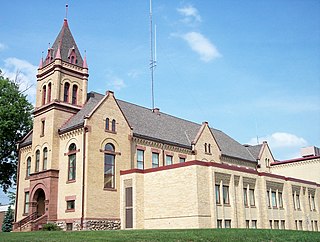
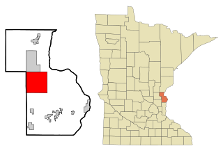
Kanabec County is a county in the U.S. state of Minnesota. As of the 2010 census, the population was 16,239. Its county seat is Mora. The county was founded on March 13, 1858, from Pine County and organized in 1882. It is named after the Ojibwe ginebig, meaning "snake," after the Snake River — Kanabecosippi — which flows through the county.

Chisago County, Minnesota county in Minnesota, United States

Chisago County is a county located in the U.S. state of Minnesota. As of the 2010 census, the population was 53,887. Its county seat is Center City. The county's name comes from Chisago Lake.

Anoka County, Minnesota county in Minnesota, United States

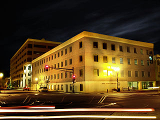
Anoka County is the fourth-most-populous county in the U.S. state of Minnesota. As of the 2010 census, the population was 339,534. The county seat and namesake of the county is the City of Anoka, which is derived from the Dakota word anokatanhan meaning "on both sides," referring to its location on the banks of the Rum River. The largest city in the county is the City of Blaine, the thirteenth-largest city in Minnesota and the eighth-largest Twin Cities suburb.

Rum River river in the United States of America

The Rum River is a slow, meandering channel that connects Minnesota's Mille Lacs Lake with the Mississippi River. It runs for 151 miles (243 km) through the communities of Onamia, Milaca, Princeton, Cambridge, Isanti, and St. Francis before ending at the Twin Cities suburb of Anoka, roughly 20 miles northwest of downtown Minneapolis. It is one of the six protected Wild and Scenic rivers in Minnesota.

Mille Lacs Indian Reservation is the popular name for the land-base for the Mille Lacs Band of Ojibwe in Central Minnesota, about 100 miles (160 km) north of Minneapolis-St. Paul. The contemporary Mille Lacs Band reservation has significant land holdings in Mille Lacs, Pine, Aitkin and Crow Wing counties, as well as other land holdings in Kanabec, Morrison, and Otter Tail Counties. Mille Lacs Indian Reservation is also the name of a formal Indian reservation established in 1855. It is one of the two formal reservations on which the contemporary Mille Lacs Band retains land holdings. The contemporary Mille Lacs band includes several aboriginal Ojibwe bands and villages, whose members reside in communities throughout central Minnesota.

Minnesota State Highway 47 is a highway in east–central Minnesota, which runs from its intersection with Central Avenue in Minneapolis and continues north to its northern terminus at its intersection with U.S. Highway 169 in Aitkin.

Sunrise River river in the United States of America

The Sunrise River is a 39.1-mile-long (62.9 km) tributary of the St. Croix River in East Central Minnesota in the United States. It is formed at the city of Forest Lake in Washington County at the outlet of Forest Lake. The river flows north, accepting the South Branch from the west near the city of Wyoming, and continues north into Mud Lake, where the West Branch, which rises in southeast Isanti County and briefly enters Anoka County, joins it near the city of Stacy. From Stacy it flows generally north-northwest through Chisago County to meet the St. Croix River within Wild River State Park near the communities of Sunrise and Almelund. Not far upstream from its mouth, the Sunrise collects its North Branch, which rises in Isanti County and flows through the city of North Branch.

Snake River (St. Croix River tributary)

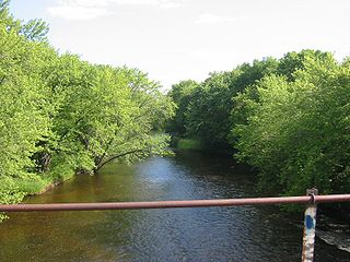
The Snake River is a 104-mile-long (167 km) tributary of the St. Croix River in East Central Minnesota in the United States. It is one of three streams in Minnesota with this name. Its name is a translation from the Ojibwa Ginebigo-ziibi, after the Dakota peoples who made their homes along this river. Kanabec County is named after this river.

The Knife River is a 27.4-mile-long (44.1 km) tributary of the Snake River in East Central Minnesota in the United States. It is one of three streams in Minnesota with this name. Its name is a translation from the Dakota Isaanti. Knife Lake and Santee Sioux are named after this river. In turn Isanti County is named after the Santee Sioux.

District Court of Minnesota

The District Court of Minnesota is the state trial court of general jurisdiction in the U.S. state of Minnesota.

County roads in Minnesota are roads locally maintained by county highway departments in Minnesota. County roads span a wide variety of road types, varying from A-minor arterials that carry large volumes of traffic to an improved road.

1996 United States presidential election in Minnesota

The 1996 United States presidential election in Minnesota took place on November 5, 1996, as part of the 1996 United States presidential election. Voters chose ten representatives, or electors to the Electoral College, who voted for president and vice president.

Greeley, Minnesota Unincorporated community in Minnesota, United States

Greeley is an unincorporated community in Royalton Township, Pine County, Minnesota, United States.

Minnesota Department of Natural Resources Enforcement Division

The Minnesota Department of Natural Resources Division of Enforcement is the law enforcement division of the Minnesota Department of Natural Resources, the State of Minnesota's Natural Resource Management State agency. The main focus of the Division of Enforcement is public safety and enforcement of the state's laws and regulations pertaining to wildlife, fishing, outdoor recreation, hunting, All-terrain vehicles, and boating throughout the state. In addition, officers patrol Department of Natural Resources lands and public waters, including Minnesota State Parks, Minnesota State Forests, Wildlife Management Areas, and Scientific & Natural Areas. Law enforcement officers in this division are called Minnesota State Conservation Officers, and are fully licensed state peace officers that have jurisdiction throughout the State of Minnesota to enforce state laws.

Rum River State Forest

The Rum River State Forest is a state forest located in Kanabec, Mille Lacs and Morrison counties in central Minnesota. The forest is nearby the city of Onamia and is along the Rum River, just downstream (south) of Mille Lacs Lake. The forest is managed by the Minnesota Department of Natural Resources. The forest is home to many Northern hardwoods such as maple, oak, ash, elm and basswood that occupy most of the upland areas while tamarack and black spruce are found in lowland and marshy areas.

References

  1. https://www.chisagocounty.us/DocumentCenter/View/7885/Environmental-Newsletter-Spring-2013?bidId=
  2. https://chisagocountypress.com/main.asp?SectionID=25&SubSectionID=127&ArticleID=20669
  3. https://bringmethenews.com/minnesota-weather/snowy-day-in-minnesota-heres-how-much-the-nws-expects-to-fall
  4. "GPS:45:93 : Opportunity Brochure" (PDF). Ci.mora.mn.us. Retrieved 10 October 2018.
  5. https://www.tcdailyplanet.net/gps-4593-region-points-more-signs-economic-opportunity/
  6. https://finance-commerce.com/2019/02/hundreds-of-new-homes-proposed-for-wyoming/
  7. https://www.hometownsource.com/isanti_county_news/news/local/east-central-minnesota-pride-event-june/article_e4c36154-fee8-550e-90bc-73f8b8e52a28.html
  8. "The Ten Largest Lakes in Minnesota - Minnesota Fun Facts". Minnesotafunfacts.com. 20 April 2010. Retrieved 10 October 2018.
  9. http://www.startribune.com/census-twin-cities-adds-quarter-million-residents-since-2010/477583833/
  10. News, Watchdog. "By the numbers: Pine Technical & Community College has lowest tuition ranking for Minnesota". Watchdog.org. Retrieved 10 October 2018.
  11. "Careers.org - Pine Technical & Community College - Academic Programs, Courses, and Degrees". Careers.org. Retrieved 10 October 2018.
  12. "Careers.org - Anoka-Ramsey Community College - Academic Programs, Courses, and Degrees". Careers.org. Retrieved 10 October 2018.

Coordinates: 45°42′N93°06′W / 45.7°N 93.1°W / 45.7; -93.1

Geographic coordinate system Coordinate system

A geographic coordinate system is a coordinate system that enables every location on Earth to be specified by a set of numbers, letters or symbols. The coordinates are often chosen such that one of the numbers represents a vertical position and two or three of the numbers represent a horizontal position; alternatively, a geographic position may be expressed in a combined three-dimensional Cartesian vector. A common choice of coordinates is latitude, longitude and elevation. To specify a location on a plane requires a map projection.