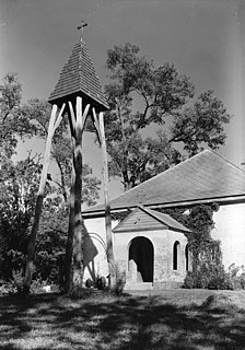
The George Washington Birthplace National Monument is a national monument in Westmoreland County, Virginia, United States. This site was a colonial tobacco plantation developed by Englishman John Washington in the mid-17th century. John Washington was a great-grandfather of George Washington, general of the Continental Army and first president of the United States of America. George Washington was born in this house on February 22, 1732. He lived here until age three, returning later to live here as a teenager.

Shadwell is a census-designated place (CDP) in Albemarle County, Virginia, United States, located by the Rivanna River near Charlottesville. The site today is marked by a Virginia Historical Marker to mark the birthplace of President Thomas Jefferson. It is listed on the National Register of Historic Places along with Clifton.

York River State Park is located near the unincorporated town of Croaker in James City County, Virginia on the south bank of the York River about 10 miles downstream from West Point.

Shockoe Bottom is an area in Richmond, Virginia, just east of downtown, along the James River. Located between Shockoe Hill and Church Hill, Shockoe Bottom contains much of the land included in Colonel William Mayo's 1737 plan of Richmond, making it one of the city's oldest neighborhoods.

Leesylvania State Park is located in the southeastern part of Prince William County, Virginia. The land was donated in 1978 by philanthropist Daniel K. Ludwig, and the park was dedicated in 1985 and opened full-time in 1992.

Kenmore, also known as Kenmore Plantation, is a plantation house at 1201 Washington Avenue in Fredericksburg, Virginia. Built in the 1770s, it was the home of Fielding and Betty Washington Lewis and is the only surviving structure from the 1,300-acre (530 ha) Kenmore plantation.

Flowerdew Hundred Plantation dates to 1618/19 with the patent by Sir George Yeardley, the Governor and Captain General of Virginia, of 1,000 acres (400 ha) on the south side of the James River. Yeardley probably named the plantation after his wife's wealthy father, Anthony Flowerdew, just as he named another plantation "Stanley Hundred" after his wife's wealthy mother, Martha Stanley. A "hundred" was historically a division of a shire or county. With a population of about 30, the plantation was economically successful with thousands of pounds of tobacco produced along with corn, fish and livestock. Sir George paid 120 pounds to build the first windmill in British America.

Broad Creek in Prince George's County was the first footprint of European settlement in the immediate counties around what would become the nation's capital, Washington, D.C. The area is part of greater Fort Washington.

Accokeek Creek Site, also known as Moyaone, is an archaeological site in Prince George's County, Maryland, located along the Potomac River across from Mount Vernon in today's Piscataway Park, which was inhabited intermittently since 2000 BC. Accokeek Creek Site was declared a National Historic Landmark in 1964.
The Bull Thistle Cave Archaeological Site is an archaeological site on the National Register of Historic Places, located in Tazewell County, Virginia. It is a vertical shaft pit burial cave. The distribution of the skeletal remains indicates that bodies were either thrown or lowered into the cave. On the surface of the cave floor, researchers have discovered the remains of a minimum of 11 bodies. Based on an artifact recovered from the site, it is estimated that the cave was used for burials between 1300 and 1600 AD.

The Herndon Depot Museum, also known as the Herndon Historical Society Museum, is located in the town of Herndon in Fairfax County, Virginia. Built in 1857 for the Alexandria, Loudoun & Hampshire Railroad, the depot later served the Richmond and Danville Railroad, the Southern Railway and the Washington and Old Dominion Railroad.

Pamplin Pipe Factory, also known as Merrill and Ford, The Akron Smoking Pipe Factory, and The Pamplin Smoking Pipe and Manufacturing Company, is a historic factory and archaeological site located at Pamplin, Appomattox County, Virginia. Located on the property are a wood-framed factory building, a deteriorating brick kiln, and a collapsed brick chimney. It began operation about 1879 and was at one time the largest clay pipe manufacturer in the United States.

Dale's Pale Archeological District is a set of historic archaeological sites and national historic district located near Chester, Chesterfield County, Virginia. The district consists of a collection of four county owned archaeological sites. They are the location of a defensive palisade built by Sir Thomas Dale in 1613 around the original settlement at Bermuda Hundred, which he founded. It is a two mile long, berm-and-ditch feature, running between the high banks overlooking the James and Appomattox Rivers. The other sites within the district include a Middle Woodland Period settlement, and a late 17th- or early 18th-century house with its associated dump.

Buffalo Springs Historical Archeological District is a historic archaeological site and national historic district located near Buffalo Springs, Mecklenburg County, Virginia. It encompasses two contributing buildings, one contributing site, and 1 contributing structure associated with the Buffalo Lithia Springs or Buffalo Mineral Springs. The mineral or lithia springs at Buffalo are mentioned in the 1728 diary kept by William Byrd, whose party camped at this location while surveying the Virginia-North Carolina border. As early as 1817, an ordinary and tavern operated at Buffalo Springs. A resort/spa continued to grow through the mid-19th century. By 1885, Buffalo Springs water was being bottled and distributed nationally and in Europe. Buffalo Springs served as important place for local gathering and socializing through the first several decades of the 20th century. Some of the original property was acquired by the government for construction of the Kerr Reservoir in the late 1940s. The district is included within the Tobacco Heritage Trail.

Brentsville Courthouse and Jail is a historic courthouse and jail located at Brentsville, Prince William County, Virginia. The courthouse was built in 1822, and is a two-story, Federal style brick building. It features a fanlight over the main entrance, within a keyed, semicircular brick arch and an octagonal-roofed, frame-built cupola. The Brentsville Jail was built about 1820, and is located 30 yards from the courthouse. It is a well-constructed, two-story, gable roofed structure. The county seat was moved to Manassas in the 1890s to the Prince William County Courthouse and the courthouse and jail were abandoned.

Conjurer's Neck Archeological District is a set of two historic archaeological sites and national historic district located at Colonial Heights, Virginia. The district includes the previously listed Conjurer's Field Archeological Site prehistoric village site (44CF20) and the site of a Colonial-period plantation house, known as the Kennon House or Old Brick House (44CF646). The original house was built between 1725 and 1750, and rebuilt in 1879 after a fire. The site possesses undisturbed and stratified cultural features dating to the late 1700s and afterward.

Conjurer's Field Archeological Site is a historic archaeological site located at Colonial Heights, Virginia. The prehistoric village site (44CF20) is one of the last of the larger Middle and Late Woodland period villages located along the Appomattox River. The site include several well preserved burials, ceramic wares, and the presence of an undisturbed prehistoric midden.

The Danville Tobacco Warehouse and Residential District is a national historic district located at Danville, Virginia. The district includes 532 contributing buildings, 3 contributing sites, and 2 contributing structures in the city of Danville. The district reflects the late-19th century and early-20th development of Danville as a tobacco processing center and includes residential, commercial, and industrial buildings reflecting that growth. It also includes archaeological sites related to early Native American settlements in the area. Notable buildings include the American Tobacco's Harris Building, the Imperial Tobacco Company Building, Cabell Warehouse, Patton Storage Units, Crowell Motor Company, Municipal Power Station (1912), Riverside Cotton Mill #1 (1886), and a variety of "shotgun" houses and bungalow workers housing. Located in the district are the separately listed Danville Municipal Building and Danville Southern Railway Passenger Depot.

Shockoe Valley is an area in Richmond, Virginia, just east of downtown, along the James River, and is the entertainment center of the city. Located between Shockoe Hill and Church Hill, Shockoe Valley contains much of the land included in Colonel William Mayo's 1737 plan of Richmond, making it one of the city's oldest neighborhoods. Shockoe Valley encompasses the smaller neighborhoods of Shockoe Slip, Shockoe Bottom and Tobacco Row along Cary Street.


