
King County is a county located in the U.S. state of Washington. The population was 2,269,675 in the 2020 census, making it the most populous county in Washington, and the 12th-most populous in the United States. The county seat is Seattle, also the state's most populous city.
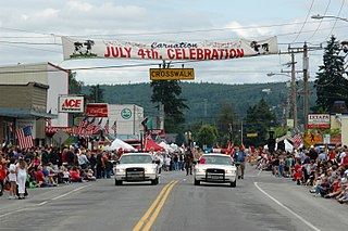
Carnation is a city in King County, Washington, United States. It was historically known as Tolt and lies at the confluence of the Snoqualmie and Tolt rivers.

Fall City is an unincorporated community and census-designated place (CDP) in King County, Washington, United States, 25 miles (40 km) east of Seattle. The community lies along the Snoqualmie River and Raging River. The population was 2,032 at the 2020 census.

North Bend is a town in King County, Washington, United States, on the outskirts of the Seattle metropolitan area. The population was 7,461 at the 2020 census. The town is 30 miles (48 km) east of Seattle on Interstate 90 and lies in the foothills of the Cascade Range near Snoqualmie Pass.

Snoqualmie is a city next to Snoqualmie Falls in King County, Washington, United States. It is 28 miles (45 km) east of Seattle. Snoqualmie is home to the Northwest Railway Museum. The population was 14,121 at the 2020 census.

The Snoqualmie River is a 45-mile (72 km) long river in King County and Snohomish County in the U.S. state of Washington. The river's three main tributaries are the North, Middle, and South Forks, which drain the west side of the Cascade Mountains near the town of North Bend and join near the town of Snoqualmie just above the Snoqualmie Falls. After the falls the river flows north through rich farmland and the towns of Fall City, Carnation, and Duvall before meeting the Skykomish River to form the Snohomish River near Monroe. The Snohomish River empties into Puget Sound at Everett. Other tributaries of the Snoqualmie River include the Taylor River and the Pratt River, both of which enter the Middle Fork, the Tolt River, which joins at Carnation, and the Raging River at Fall City.

The Stillaguamish River is a river in the northwestern region of the U.S. state of Washington. It is mainly composed of two forks, the longer North Fork Stillaguamish and the South Fork Stillaguamish. The two forks join near Arlington. From there the Stillaguamish River proper flows for 22 miles (35 km) to Puget Sound. The river's watershed drains part of the Cascade Range north of Seattle.

The Snoqualmie Indian Tribe is a federally recognized tribe of Snoqualmie people. They are Coast Salish Native American peoples from the Snoqualmie Valley in east King and Snohomish Counties in Washington state. Other names for the Snoqualmies include Snoqualmu, Snoqualmoo, Snoqualmick, Snoqualamuke, and Snuqualmi.

The Snoqualmie Valley is a farming and timber-producing region located along the Snoqualmie River in Western Washington, United States. The valley stretches from the confluence of the three forks of the river at North Bend to the confluence of the Snoqualmie River and the Skykomish River, forming the Snohomish River at Monroe. This stretch of the river includes Snoqualmie Falls. Towns in the valley are North Bend, Snoqualmie, Preston, Fall City, Carnation, and Duvall.

Alpental, named after the German word for alpine valley, is both a valley in eastern King County, Washington, United States, and part of a ski area in the valley. The valley is about 50 miles (80 km) east of Seattle, Washington and is north of Snoqualmie Pass, in the Washington Cascades. It is a popular outdoor recreation destination in summer and winter. The ski area is one of four areas that make up The Summit at Snoqualmie.

The Alpine Lakes Wilderness is a large wilderness area spanning the Central Cascades of Washington state in the United States. The wilderness is located in parts of Wenatchee National Forest and Snoqualmie National Forest, and is approximately bounded by Interstate 90 and Snoqualmie Pass to the south and U.S. Route 2 and Stevens Pass to the north. The Alpine Lakes is the largest wilderness area near the population centers of Puget Sound, counted at 414,161 acres (167,605 ha) following the 2014 expansion.

State Route 202 (SR 202) is a state highway in the U.S. state of Washington, serving part of the Seattle metropolitan area. It runs southeasterly for 31 miles (50 km) in the Eastside region of King County, connecting Woodinville, Redmond, Fall City, and North Bend. The highway begins at SR 522 in Woodinville, intersects SR 520 in Redmond and SR 203 in Fall City, and terminates at Interstate 90 (I-90) in North Bend. The entire highway is designated as the Cascade Valleys Scenic Byway, a state scenic and recreational highway.
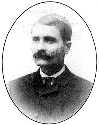
William Taylor, (1853–1941) was a pioneer, Snoqualmie Valley driving force and the founder of North Bend, Washington in February 1889.

Fantastic Falls is a waterfall on the North fork of the Snoqualmie River in the U.S. state of Washington. At 35 feet (11 m), is the largest of several small waterfalls in the Ernie's Grove area.

Franklin Falls is a waterfall on the South fork of the Snoqualmie River, the first of three major waterfalls on the South Fork Snoqualmie River. The falls are located near Snoqualmie Pass in King County, Washington, United States, between the north and south lanes of Interstate 90, just east of exit 47. The falls actually consist of three tiers, totaling about 135 feet (41 m). The first drop is a very scenic 15-foot (4.6 m) block-shaped fall. The second drop is a 25-foot (7.6 m) fanning cascade. The final drop begins as a 25-foot slide, which bends to the right, then plunges over the final 70-foot (21 m) drop seen from the base of the falls. The falls are popular canyoneering destination. The upper two drops are north of the freeway.

Interstate 90 (I-90), designated as the American Veterans Memorial Highway, is a transcontinental Interstate Highway that runs from Seattle, Washington, to Boston, Massachusetts. It crosses Washington state from west to east, traveling 298 miles (480 km) from Seattle across the Cascade Mountains and into Eastern Washington, reaching the Idaho state line east of Spokane. I-90 intersects several of the state's other major highways, including I-5 in Seattle, I-82 and U.S. Route 97 (US 97) near Ellensburg, and US 395 and US 2 in Spokane.

Boulder River Wilderness is a 48,674-acre (197 km2) wilderness area within the Mount Baker-Snoqualmie National Forest in the western Cascade Range of Washington state.
Forterra, based in Seattle, Washington, US, is the state of Washington's largest land conservation, stewardship and community building organization dedicated solely to the region.
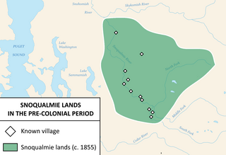
The Snoqualmie people are a Lushootseed-speaking Southern Coast Salish people indigenous to the Snoqualmie Valley, located in east King and Snohomish counties in the state of Washington.


