Eudora, Arkansas

Last updated

Eudora, Arkansas
Eudora tank n town.jpg
Eudora - Catfish Capital of Arkansas
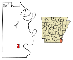
Chicot County Arkansas Incorporated and Unincorporated areas Eudora Highlighted 0522180.svg
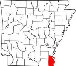
Location of Eudora in Chicot County, Arkansas.
Coordinates: 33°07′30″N91°15′44″W / 33.12500°N 91.26222°W / 33.12500; -91.26222
Country United States
State Arkansas
County Chicot
Area
[1]
  Total3.09 sq mi (8.01 km2)
  Land3.09 sq mi (8.01 km2)
  Water0.00 sq mi (0.00 km2)
Elevation
[2]
135 ft (41 m)
Population
 (2020)
  Total1,728
  Density558.68/sq mi (215.71/km2)
Time zone UTC-6 (Central (CST))
  Summer (DST) UTC-5 (CDT)
ZIP code
71640
Area code 870
FIPS code 05-22180
GNIS feature ID2403574 [2]
Website cityofeudora.municipalimpact.com

Eudora is a city in Chicot County, Arkansas, United States. The population was 2,269 at the 2010 census, [3] down from 2,819 in 2000.

Contents

Geography

Eudora is located in southern Chicot County. U.S. Route 65 passes through the city, leading north 17 miles (27 km) to Lake Village, the Chicot County seat, northeast (via U.S. Route 82) 29 miles (47 km) to Greenville, Mississippi, and south 24 miles (39 km) to Lake Providence, Louisiana. Grand Lake, a former channel of the Mississippi River, is 4 miles (6 km) to the southeast.

According to the United States Census Bureau, Eudora has a total area of 3.1 square miles (7.9 km2), all land. [3]

Demographics

Historical population
CensusPop.Note
1910 606
1920 1,19797.5%
1930 2,02068.8%
1940 1,808−10.5%
1950 3,07269.9%
1960 3,59817.1%
1970 3,6872.5%
1980 3,8404.1%
1990 3,155−17.8%
2000 2,819−10.6%
2010 2,269−19.5%
2020 1,728−23.8%
U.S. Decennial Census [4]
2014 Estimate [5]

2020 census

Eudora Racial Composition [6]
RaceNum.Perc.
White 1005.79%
Black or African American 1,56090.28%
Native American 20.12%
Pacific Islander 40.23%
Other/Mixed 352.03%
Hispanic or Latino 271.56%

As of the 2020 United States Census, there were 1,728 people, 886 households, and 587 families residing in the city.

2010 census

As of the 2010 United States Census, there were 2,269 people living in the city. The racial makeup of the city was 89.3% Black, 9.1% White, 0.4% Native American, <0.1% Asian and 0.2% from two or more races. 1.0% were Hispanic or Latino of any race.

2000 census

As of the census [7] of 2000, there were 2,819 people, 1,047 households, and 731 families living in the city. The population density was 918.2 inhabitants per square mile (354.5/km2). There were 1,163 housing units at an average density of 378.8 per square mile (146.3/km2). The racial makeup of the city was 13.94% White, 84.50% Black or African American, 0.04% Native American, 0.18% Asian, 0.46% from other races, and 0.89% from two or more races. 1.38% of the population were Hispanic or Latino of any race.

There were 1,047 households, out of which 34.9% had children under the age of 18 living with them, 30.5% were married couples living together, 34.7% had a female householder with no husband present, and 30.1% were non-families. 26.6% of all households were made up of individuals, and 14.2% had someone living alone who was 65 years of age or older. The average household size was 2.69 and the average family size was 3.24.

In the city, the population was spread out, with 32.4% under the age of 18, 9.4% from 18 to 24, 23.7% from 25 to 44, 20.0% from 45 to 64, and 14.6% who were 65 years of age or older. The median age was 33 years. For every 100 females, there were 80.2 males. For every 100 females age 18 and over, there were 68.9 males. The median income for a household in the city was $17,857, and the median income for a family was $19,840. Males had a median income of $20,729 versus $15,262 for females. The per capita income for the city was $9,437. About 34.6% of families and 36.5% of the population were below the poverty line, including 43.3% of those under age 18 and 30.0% of those age 65 or over.

Eudora has one grocery store, two dollar stores, and a factory that is the county's largest employer.

Climate

The climate in this area is characterized by hot, humid summers and mild winters. Eudora has a humid subtropical climate (Köppen 'Cfa', Trewartha 'Cf'). [8] [9] Temperature extremes since 1962 have ranged from 3 °F (-16 °C) in January 1982 and December 1989 to 108 °F (42 °C) in September 2000 and August 2011. More typically, a year will range from 17 °F (-8 °C) to 102 °F (39 °C). [8]

Eudora is the warmest populated area in Arkansas. [10]

Climate data for Eudora, Arkansas, 1991–2020 normals, extremes 1962–present
MonthJanFebMarAprMayJunJulAugSepOctNovDecYear
Record high °F (°C)80
(27)
85
(29)
89
(32)
96
(36)
98
(37)
103
(39)
105
(41)
108
(42)
108
(42)
102
(39)
90
(32)
89
(32)
108
(42)
Mean maximum °F (°C)74.5
(23.6)
78.2
(25.7)
83.4
(28.6)
88.1
(31.2)
92.8
(33.8)
97.2
(36.2)
99.9
(37.7)
101.0
(38.3)
98.8
(37.1)
92.2
(33.4)
83.1
(28.4)
76.5
(24.7)
102.0
(38.9)
Mean daily maximum °F (°C)54.6
(12.6)
59.1
(15.1)
67.4
(19.7)
75.6
(24.2)
83.7
(28.7)
90.1
(32.3)
93.0
(33.9)
93.5
(34.2)
88.8
(31.6)
78.8
(26.0)
66.8
(19.3)
57.3
(14.1)
75.7
(24.3)
Daily mean °F (°C)44.4
(6.9)
48.2
(9.0)
56.1
(13.4)
63.9
(17.7)
72.6
(22.6)
79.8
(26.6)
82.4
(28.0)
82.1
(27.8)
76.6
(24.8)
65.9
(18.8)
54.8
(12.7)
46.9
(8.3)
64.5
(18.1)
Mean daily minimum °F (°C)34.3
(1.3)
37.3
(2.9)
44.8
(7.1)
52.3
(11.3)
61.5
(16.4)
69.5
(20.8)
71.8
(22.1)
70.7
(21.5)
64.5
(18.1)
53.0
(11.7)
42.7
(5.9)
36.4
(2.4)
53.2
(11.8)
Mean minimum °F (°C)19.4
(−7.0)
23.7
(−4.6)
28.6
(−1.9)
36.9
(2.7)
48.1
(8.9)
59.5
(15.3)
64.7
(18.2)
61.9
(16.6)
50.9
(10.5)
37.1
(2.8)
27.3
(−2.6)
22.9
(−5.1)
17.3
(−8.2)
Record low °F (°C)3
(−16)
10
(−12)
16
(−9)
27
(−3)
37
(3)
50
(10)
52
(11)
53
(12)
38
(3)
27
(−3)
16
(−9)
3
(−16)
3
(−16)
Average precipitation inches (mm)6.09
(155)
5.78
(147)
5.46
(139)
6.63
(168)
4.75
(121)
4.17
(106)
4.07
(103)
4.17
(106)
4.12
(105)
4.65
(118)
4.72
(120)
5.85
(149)
60.46
(1,537)
Average snowfall inches (cm)0.1
(0.25)
0.0
(0.0)
0.0
(0.0)
0.0
(0.0)
0.0
(0.0)
0.0
(0.0)
0.0
(0.0)
0.0
(0.0)
0.0
(0.0)
0.0
(0.0)
0.0
(0.0)
0.0
(0.0)
0.1
(0.25)
Average precipitation days (≥ 0.01 in)10.39.69.88.28.67.97.77.06.06.67.89.799.2
Average snowy days (≥ 0.1 in)0.10.20.00.00.00.00.00.00.00.00.00.00.3
Source 1: NOAA [11]
Source 2: National Weather Service [12]

Culture

In 1970 Tony Joe White released a song on his self-titled album entitled "They Caught the Devil and Put Him in Jail in Eudora, Arkansas."

Education

The Lakeside School District operates public schools. On February 13, 2006, the Eudora School District consolidated into the Lakeside district. [13]

The Southeast Arkansas Public Library operates the Eudora Branch Library. [14]

Notable people

See also

Related Research Articles

<span class="mw-page-title-main">Chicot County, Arkansas</span> County in Arkansas, United States

Chicot County is a county located in the southeastern corner of the U.S. state of Arkansas. As of the 2020 census, the population was 10,208. The county seat is Lake Village. Chicot County is Arkansas's 10th county, formed on October 25, 1823, and named after Point Chicot on the Mississippi River. It is part of the Arkansas Delta, lowlands along the river that have been historically important as an area for large-scale cotton cultivation.

<span class="mw-page-title-main">Almyra, Arkansas</span> Town in Arkansas, United States

Almyra is a town in Arkansas County, Arkansas, United States. The population was 283 at the 2010 census.

<span class="mw-page-title-main">Hamburg, Arkansas</span> City in Arkansas

Hamburg is a city and county seat of Ashley County, Arkansas, United States. The population was 2,857 at the 2010 census. It is the home town of NBA player Scottie Pippen.

<span class="mw-page-title-main">Portland, Arkansas</span> City in Arkansas, United States

Portland is a city in Ashley County, Arkansas, United States. The population was 430 at the 2010 census. Portland was first settled in the 1830s, and named for its early status as a steamboat port. It was incorporated in 1893.

<span class="mw-page-title-main">Diamond City, Arkansas</span> City in Arkansas, United States

Diamond City is a city in northeast Boone County, Arkansas, United States. The population was 782 at the 2010 census. It is part of the Harrison Micropolitan Statistical Area.

<span class="mw-page-title-main">Thornton, Arkansas</span> City in Arkansas, United States

Thornton is a city in Calhoun County, Arkansas, United States. The population was 407 as of the 2010 census, down from 517 in 2000. It is part of the Camden, Arkansas micropolitan area.

<span class="mw-page-title-main">Dermott, Arkansas</span> City in Arkansas, United States

Dermott is a city in Chicot County, Arkansas, United States. The population was 2,316 at the 2010 census. Dermott was incorporated in 1890.

<span class="mw-page-title-main">Lake Village, Arkansas</span> City in Arkansas, United States

Lake Village is a city in and the county seat of Chicot County, Arkansas, United States. The population was 2,575 at the 2010 census. It is located in the Arkansas Delta. Lake Village is named for its location on Lake Chicot, an oxbow lake formed by the Mississippi River.

<span class="mw-page-title-main">Mountainburg, Arkansas</span> City in Arkansas, United States

Mountainburg is a town in Crawford County, Arkansas, United States. It is part of the Fort Smith, Arkansas-Oklahoma Metropolitan Statistical Area. As of the 2010 census the population was 631.

<span class="mw-page-title-main">Calico Rock, Arkansas</span> City in Arkansas, United States

Calico Rock is a city in Izard County, Arkansas, United States. The population was 1,545 at the 2010 census, up from 991 in 2000.

<span class="mw-page-title-main">Buckner, Arkansas</span> City in Arkansas, United States

Buckner is a city in Lafayette County, Arkansas, United States. The population was 275 at the 2010 census.

<span class="mw-page-title-main">Lexa, Arkansas</span> Town in Arkansas, United States

Lexa is a town in northern Phillips County, Arkansas, United States. The population was 286 at the 2010 census.

<span class="mw-page-title-main">Hazen, Arkansas</span> City in Arkansas, United States

Hazen is a city in Prairie County, Arkansas, United States. The population was 1,481 at the 2020 census.

<span class="mw-page-title-main">Waldron, Arkansas</span> City in Arkansas, United States

Waldron is a city in Scott County, Arkansas, United States. Its population was 3,386 at the 2020 census. The city is the county seat of Scott County.

<span class="mw-page-title-main">Calion, Arkansas</span> City in Arkansas, United States

Calion is a second-class city in Union County, Arkansas, United States. The population was 494 at the 2010 census.

<span class="mw-page-title-main">Ola, Arkansas</span> City in Arkansas, United States

Ola is a city in Yell County, Arkansas, United States. The population was 1,281 at the 2010 census. It is roughly 15 miles south of the Russellville Metropolitan area.

<span class="mw-page-title-main">Gladwin, Michigan</span> City in Michigan, United States

Gladwin is a city in Gladwin County in the U.S. state of Michigan. The population was 3,069 at the 2020 census. Gladwin is the county seat of Gladwin County. The city is at the southwest corner of Gladwin Township, but the two are administered autonomously.

<span class="mw-page-title-main">Morenci, Michigan</span> City in Michigan, United States

Morenci is a city in Lenawee County in the U.S. state of Michigan. Sharing a southern boundary with the state of Ohio, it is the southernmost city in the state of Michigan. The population was 2,270 at the 2020 census.

QulinKEW-lin is a city located in Butler County in Southeast Missouri, United States. The population was 460 at the 2020 census.

<span class="mw-page-title-main">Goldthwaite, Texas</span> City in Texas, United States

Goldthwaite is a town and the county seat of Mills County, Texas, United States. The population was 1,878 at the 2010 census.

References

  1. "2020 U.S. Gazetteer Files". United States Census Bureau. Retrieved October 29, 2021.
  2. 1 2 U.S. Geological Survey Geographic Names Information System: Eudora, Arkansas
  3. 1 2 "Geographic Identifiers: 2010 Demographic Profile Data (G001): Eudora city, Arkansas". U.S. Census Bureau, American Factfinder. Archived from the original on February 12, 2020. Retrieved June 16, 2014.
  4. "Census of Population and Housing". Census.gov. Retrieved June 4, 2015.
  5. "Annual Estimates of the Resident Population for Incorporated Places: April 1, 2010 to July 1, 2014". Archived from the original on May 22, 2015. Retrieved June 4, 2015.
  6. "Explore Census Data". data.census.gov. Retrieved December 7, 2021.
  7. "U.S. Census website". United States Census Bureau . Retrieved January 31, 2008.
  8. 1 2 "Climate".
  9. "Humid subtropical climate".
  10. "The Coldest and Warmest Cities in Every State".
  11. "U.S. Climate Normals Quick Access – Station: Eudora, AR". National Oceanic and Atmospheric Administration. Retrieved April 30, 2023.
  12. "NOAA Online Weather Data – NWS Jackson". National Weather Service. Retrieved April 30, 2023.
  13. "ConsolidationAnnex_from_1983.xls Archived 2015-09-12 at the Wayback Machine ." Arkansas Department of Education. Retrieved on October 13, 2017.
  14. "Home". Southeast Arkansas Public Library. Retrieved May 18, 2023. - Check the hours and locations tab: "161 N. Cherry Eudora, AR 71640"