Mau, also now known as Maunath Bhanjan, is an industrial town and the headquarter of the Mau district. It is located in the eastern part of Uttar Pradesh, India. The town is known for its saree industry which is a traditional business and centuries old art of the people of this city; says, Pallavi Mishra.

Ettayapuram is a panchayat town in Thoothukudi district of Tamil Nadu, India. It is the birthplace of Tamil poets Mahakavi Bharathiar and Umaru Pulavar. Muthuswami Dikshitar, one of the triads of Carnatic music, was patronized in his final years by the ruler of Ettayapuram.

Nakodar is a town and a municipal council in Jalandhar district in the Indian state of Punjab.
Narwar is a town and a nagar panchayat in Shivpuri district in the Indian state of Madhya Pradesh. Narwar is a historic town and the Narwar Fort is just east of the Kali Sindh River and is situated at a distance of 42 km from Shivpuri. Narwar was known as Narwar District during the times of Gwalior State. It is mentioned as Nalpura in many medieval Sanskrit inscriptions. The Narwar Fort is surrounded by the Kali Sindh River. There are three dams, Harsi Dam, Mohini Sagar and Atal Sagar. Presently the Fort is being renovated by the Archaeological Survey of India.

Rajapalayam is a town in the Indian state of Tamil Nadu. It is the largest municipality in the Virudhunagar district. Rajapalayam is located on the Madurai to Quilon National Highway at a distance of 562 km south of the state capital Chennai. The economy is primarily industrial with several mills for spinning and weaving. The town is known for its mango and the Rajapalayam breed of dogs.

Bhadohi district is a district of Uttar Pradesh state in northern India. It is also referred to as Sant Ravidas Nagar. It is the smallest district by area in the state of Uttar Pradesh which was created on June 30, 1994 by dividing western part of the district Varanasi. It is surrounded by Varanasi district on east, Allahabad on west, Jaunpur north and Mirzapur district in south. The state capital Lucknow is distanced at 234 KM from Bhadohi. Its district headquarters is situated in the city of Gyanpur. The district is popularly known for carpet weaving as it is one of largest centres of Carpet Industries in India and therefore it also known as the 'Carpet City of India'. Carpets of Bhadohi have 'Geographical Indication' tag attached to it. Bhadohi has huge geographical significance and position attached to it due to its location between two culturally important and rich heritage cities of Prayagraj and Varanasi.
Anakaputhur is a neighborhood in the city of Tambaram, situated within the Chennai Metropolitan Area, Tamil Nadu, India.
Bisokhar is a census town in Ghaziabad district in the state of Uttar Pradesh, India. Bisokhar is a village in District Ghaziabad in state of Uttar Pradesh, India. Geographically it is located on Delhi - Meerut Highway in the town of Modinagar which is an Industrial town of western UP. More than half land belonging to the village is in modinagar while other is still used as agriculture land. Modinagar railway station is 3 km away. It has an elected village panchayat. People living here belong to primarily Religion Hindu and Muslim.
Dhandera Rajputana is a census town in Haridwar district in the state of Uttarakhand, India. Dhandera is located at 29.84°N 77.89°E.
Ilkal is a City in Bagalkot district in the Indian state of Karnataka. The town is located in a valley that lies in south-east corner of Bagalkot district and is quite close to the borders of Kushtagi taluk of the Koppal district. Now Ilkal city becomes taluk previous the city falls within the jurisdiction of Hungund taluk and lies at a distance of about 12 km (7.5 mi) south of taluk headquarters. Between these two towns, Ilkal is an important centre of trade, commerce, education, and industry. Ilkal is well connected with state and national highways. It is also famous for its hospitality and education institutions.
Jansath is a town and a nagar panchayat in Muzaffarnagar district in the Indian state of Uttar Pradesh.

Khirpai, also known as Kshirpai, is a city and a municipality in the Ghatal subdivision of the Paschim Medinipur district in the state of West Bengal, India. Earlier it was part of Hooghly. The city is situated between Ghatal and Chandrakona, near the banks of the rivers Shilabati and Kethai, and is one of the oldest municipalities in India. Khirpai is also famous for its Babarsa, a special type of sweetmeat, which is not available elsewhere.
Laharpur is a town, tehsil headquarter and a municipal board in Sitapur district in the Indian state of Uttar Pradesh.

Palladam is a town and First Grade Municipality in Tirupur district in the state of Tamil Nadu, India. It is the headquarters of Palladam Taluk of Tirupur district. Palladam is located on National Highway NH 81. Palladam is a major town with large source of income collected from the business community, which includes Textile industries, Poultry farms, and Agriculture. Palladam High-tech weaving park is a milestone of the town. It is a part of the Coimbatore MP Constituency. Palladam is well known for production of Broiler chicken production and head office of Broiler coordination committee (BCC) situated here.
Parsadepur, also spelled Parshadepur, is a town and a nagar panchayat in Rae Bareli district in the Indian state of Uttar Pradesh. It is located on the north bank of the Sai river, at the crossroads between the road from Salon to Jais and the smaller road from Raebareli to Ateha. Historically noted for its large weaving industry, Parsadepur served as the headquarters of a pargana since the late 18th century. As of 2011, its population is 11,853 people, in 1,738 households.
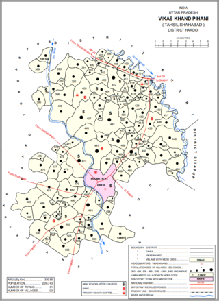
Pihani is a town and nagar palika parishad in Hardoi district of Uttar Pradesh, India. Historically, the city was a centre of sword production, leading to at least one British writer calling it "the Damascus of Oudh". Today, important industries in Pihani include jaggery and woven carpets. As of 2011, the town's population is 36,014, in 5,626 households. Pihani also serves as the headquarters of a community development block in Shahabad tehsil.
Rahon is a city and a municipal council in the district Shaheed Bhagat Singh Nagar of the Indian state of Punjab. Rahon is in Doaba region of Punjab. Doaba also known as Bist Doab, is the region of Punjab, India that lies between the Beas River and the Sutlej River. A famous battle was fought here between Sikhs and Mughals i.e Battle of Rahon (1710).

Usilampatti is a town and a second grade municipality of Madurai district in the Indian state of Tamil Nadu. It is also a designated taluk and revenue division.
Niwari is a town, near city of Ghaziabad in Ghaziabad district in the Indian state of Uttar Pradesh.

Sankrail is a community development block that forms an administrative division in Howrah Sadar subdivision of Howrah district in the Indian state of West Bengal.
District Gazettier of United Province of Agra and Oudh- 1904 by H.M.Elliot Pages 65,73.145 and 223
