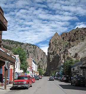
The historic City of Creede is a statutory town that is the county seat and the only incorporated municipality in Mineral County, Colorado, United States. The town population was 290 at the 2010 United States Census.

The Cumberland River is a major waterway of the Southern United States. The 688-mile-long (1,107 km) river drains almost 18,000 square miles (47,000 km2) of southern Kentucky and north-central Tennessee. The river flows generally west from a source in the Appalachian Mountains to its confluence with the Ohio River near Paducah, Kentucky, and the mouth of the Tennessee River. Major tributaries include the Obey, Caney Fork, Stones, and Red rivers.

The Ridge-and-Valley Appalachians, also called the Ridge and Valley Province or the Valley and Ridge Appalachians, are a physiographic province of the larger Appalachian division and are also a belt within the Appalachian Mountains extending from southeastern New York through northwestern New Jersey, westward into Pennsylvania and southward into Maryland, West Virginia, Virginia, Kentucky, Tennessee, Georgia and Alabama. They form a broad arc between the Blue Ridge Mountains and the Appalachian Plateau physiographic province. They are characterized by long, even ridges, with long, continuous valleys in between.

Mount Columbia is a high mountain summit of the Collegiate Peaks in the Sawatch Range of the Rocky Mountains of North America. The 14,077-foot (4,291 m) fourteener is located in the Collegiate Peaks Wilderness of San Isabel National Forest, 9.9 miles (16.0 km) northwest by west of the Town of Buena Vista in Chaffee County, Colorado, United States. The mountain was named in honor of Columbia University in the City of New York and in commemoration of its rowing victory at the renowned Henley Royal Regatta in 1878.

The Ausable River, also known as AuSable River and originally written as "Au Sable", runs in the U.S. state of New York, from the Adirondack Mountains and past the village of Lake Placid and Au Sable Forks to empty into Lake Champlain. It has an East and West branch that join at Au Sable Forks. The river forms a partial boundary between Clinton County and Essex County. The Ausable River is known for its gorge, Ausable Chasm, located a few miles east of Keeseville.

The Shenandoah River is a tributary of the Potomac River, 55.6 miles (89.5 km) long with two forks approximately 100 miles (160 km) long each, in the U.S. states of Virginia and West Virginia. The principal tributary of the Potomac, the river and its tributaries drain the central and lower Shenandoah Valley and the Page Valley in the Appalachians on the west side of the Blue Ridge Mountains, in northwestern Virginia and the Eastern Panhandle of West Virginia.

The Boise River is a 102-mile-long (164 km) tributary of the Snake River in the northwestern United States. It drains a rugged portion of the Sawtooth Range in southwestern Idaho northeast of Boise, as well as part of the western Snake River Plain. The watershed encompasses approximately 4,100 square miles (11,000 km2) of highly diverse habitats, including alpine canyons, forest, rangeland, agricultural lands, and urban areas.
The North Fork of the East Branch of the Pemigewasset River is a 6.9-mile-long (11.1 km) river located in the White Mountains of New Hampshire in the United States. It is a tributary of the East Branch of the Pemigewasset River, part of the Merrimack River watershed.

North Fork Mountain is a quartzite-capped mountain ridge in the Ridge and Valley physiographic province of the Allegheny Mountains of eastern West Virginia, USA. Kile Knob, at 4,588 feet, is the mountain's highest point, and Panther Knob and Pike Knob are nearly as high.

The North Fork John Day Wilderness is a wilderness area within the Umatilla and Wallowa–Whitman National Forests in the Blue Mountains of northeastern Oregon.

Dial Mountain is a mountain located in Essex County, New York. The mountain is part of the Colvin Range. Dial Mountain is flanked to the southwest by Nippletop.
Nippletop is a mountain located in Essex County, New York. The mountain is part of the Colvin Range. Nippletop is flanked to the northeast by Dial Mountain. To the east, it faces Dix Mountain across Hunters Pass, and to the west it faces Mount Colvin across Elk Pass.

Grace Peak is a mountain located in Essex County, New York. It is part of the Dix Range, named after John A. Dix (1798–1879), New York Secretary of State in 1837, and later Governor. The mountain was formerly called East Dix, but in 2014 it was officially renamed Grace Peak in honor of Grace Hudowalski (1906–2004), who in 1937 became the ninth person and first woman to climb all 46 of the Adirondack High Peaks. Grace Peak is flanked to the northeast by Spotted Mountain, and to the southwest by South Dix.
South Dix is a mountain located in Essex County, New York. The mountain is part of the Dix Range, named after John A. Dix (1798–1879), New York Secretary of State in 1837, and later Governor. The name is being changed to Carson Peak, after Russell M.L. Carson (1884–1961), author of Peaks and People of the Adirondacks. South Dix is flanked to the northeast by Grace Peak, to the northwest by Hough Peak, and to the southwest by Macomb Mountain.

Hough Peak is a mountain located in Essex County, New York. The mountain, part of the Dix Range, is named after Franklin B. Hough (1822–1885), the first chief of the United States Division of Forestry, and sometimes called the "father of American forestry". Hough Peak is flanked to the north by Dix Mountain, and to the south by South Dix.

Graham Mountain is the seventh highest of the Catskill High Peaks and the highest privately owned mountain in the range. It is located in the town of Hardenburgh, New York, United States.

The Yolla Bolly–Middle Eel Wilderness is a federally designated wilderness area in the Yolla Bolly Range of the southern Klamath Mountains and the Inner Northern California Coast Ranges, in Northern California.
Mount Markham is a mountain in the Central New York region of New York. It is located southeast of Unadilla Forks, New York. On 1903 topographic maps it appears as "Fork Mountain", due to its proximity to the fork of the Unadilla River.


