
Long Valley Caldera is a depression in eastern California that is adjacent to Mammoth Mountain. The valley is one of the Earth's largest calderas, measuring about 20 mi (32 km) long (east-west), 11 mi (18 km) wide (north-south), and up to 3,000 ft (910 m) deep.

The Alabama Hills are a range of hills and rock formations near the eastern slope of the Sierra Nevada in the Owens Valley, west of Lone Pine in Inyo County, California.

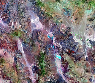
The Mono–Inyo Craters are a volcanic chain of craters, domes and lava flows in Mono County, Eastern California. The chain stretches 25 miles (40 km) from the northwest shore of Mono Lake to the south of Mammoth Mountain. The Mono Lake Volcanic Field forms the northernmost part of the chain and consists of two volcanic islands in the lake and one cinder cone volcano on its northwest shore. Most of the Mono Craters, which make up the bulk of the northern part of the Mono–Inyo chain, are phreatic volcanoes that have since been either plugged or over-topped by rhyolite domes and lava flows. The Inyo volcanic chain form much of the southern part of the chain and consist of phreatic explosion pits, and rhyolitic lava flows and domes. The southernmost part of the chain consists of fumaroles and explosion pits on Mammoth Mountain and a set of cinder cones south of the mountain; the latter are called the Red Cones.

The Lassen volcanic area presents a geological record of sedimentation and volcanic activity in and around Lassen Volcanic National Park in Northern California, U.S. The park is located in the southernmost part of the Cascade Mountain Range in the Pacific Northwest region of the United States. Pacific Oceanic tectonic plates have plunged below the North American Plate in this part of North America for hundreds of millions of years. Heat and molten rock from these subducting plates has fed scores of volcanoes in California, Oregon, Washington and British Columbia over at least the past 30 million years, including these in the Lassen volcanic areas.

Indian Heaven is a volcanic field in Skamania County in the state of Washington, in the United States. Midway between Mount St. Helens and Mount Adams, the field dates from the Pleistocene to the early Holocene epoch. It trends north to south and is dominated by six small shield volcanoes; these shields are topped by small spatter and cinder cones, and the field includes a number of subglacial volcanoes and tuyas. The northernmost peak in the field is Sawtooth Mountain and the southernmost is Red Mountain; its highest point is Lemei Rock at an elevation of 5,925 feet (1,806 m).
The exposed geology of the Death Valley area presents a diverse and complex set of at least 23 formations of sedimentary units, two major gaps in the geologic record called unconformities, and at least one distinct set of related formations geologists call a group. The oldest rocks in the area that now includes Death Valley National Park are extensively metamorphosed by intense heat and pressure and are at least 1700 million years old. These rocks were intruded by a mass of granite 1400 Ma and later uplifted and exposed to nearly 500 million years of erosion.

Pisgah Crater, or Pisgah Volcano, is a young volcanic cinder cone rising above a lava plain in the Mojave Desert, between Barstow and Needles, California in San Bernardino County, California. The volcanic peak is around 2.5 miles (4.0 km) south of historic U.S. Route 66-National Old Trails Highway and of Interstate 40, and west of the town of Ludlow. The volcano had a historic elevation of 2,638 feet (804 m), but has been reduced to 2,545 feet (776 m) due to mining.

The Coso Volcanic Field is located in Inyo County, California, at the western edge of the Basin and Range geologic province and northern region of the Mojave Desert. The Fossil Falls are part of the Coso Field, created by the prehistoric Owens River. They are within the Naval Air Weapons Station China Lake and northeast of Little Lake and U.S. Route 395.
The Coso Range of eastern California is located immediately south of Owens Lake, east of the Sierra Nevada, and west of the Argus Range. The southern part of the range lies in the restricted Naval Air Weapons Station China Lake and the northern part of the range is designated as the Coso Range Wilderness. The mountains include Coso Peak, at 8,160 feet (2,487 m) above sea level, as well as Silver Peak and Silver Mountain, both more than 7,400 ft (2,300 m) in height.
Mount Edziza is a volcanic mountain in Cassiar Land District of northwestern British Columbia, Canada. It is located on the Big Raven Plateau of the Tahltan Highland which extends along the western side of the Stikine Plateau. Mount Edziza has an elevation of 2,786 metres, making it the highest point of the Mount Edziza volcanic complex and one of the highest volcanoes in Canada. However, it had an elevation of at least 3,396 metres before its formerly cone-shaped summit was likely destroyed by a violent eruption in the geologic past; its current flat summit contains an ice-filled, 2-kilometre-in diameter (1.2-mile) crater. The mountain contains several lava domes, cinder cones and lava fields on its flanks, as well as an ice cap containing several outlet glaciers which extend to lower elevations. All sides of Mount Edziza are drained by tributaries of Mess Creek and Kakiddi Creek which are situated within the Stikine River watershed.

The Spectrum Range, formerly gazetted as the Spectrum Mountains and the Rainbow Mountains, is a small mountain range in Cassiar Land District of northwestern British Columbia, Canada. Located at the southern end of the Tahltan Highland, it borders the Skeena Mountains in the east and the Boundary Ranges of the Coast Mountains in the west. The Spectrum Range is surrounded by the Arctic Lake Plateau in the southwest and the Kitsu Plateau in the northwest, both of which contain volcanic features such as cinder cones. It lies at the southern end of the Mount Edziza volcanic complex which includes the two neighbouring plateaus, as well as Mount Edziza and the Big Raven Plateau to the north. The mountain range is drained on all sides by streams within the Stikine River watershed and, unlike Mount Edziza to the north, contains relatively small separate glaciers. Mount Edziza Provincial Park is the main protected area surrounding the Spectrum Range.

Moses Coulee is a canyon in the Waterville plateau region of Douglas County, Washington. Moses Coulee is the second-largest and westernmost canyon of the Channeled Scablands, located about 30 kilometres (19 mi) to the west of the larger Grand Coulee. This water channel is now dry, but during glacial periods, large outburst floods with discharges greater than 600,000 m3/s (21,000,000 cu ft/s) carved the channel. While it's clear that glacial floodwaters passed through and contributed to the erosion of Moses Coulee, the age of those waters, thus the origins of the coulee are less clear. No clear connection between the head of the coulee and major flood routes to the north, east, or west is known. Some researchers propose that floods from glacial Lake Missoula formed Moses Coulee, while others suggest that subglacial floods from the Okanogan Lobe incised the canyon. The mouth of Moses Coulee discharges into the Columbia River.
The Withrow Moraine and Jameson Lake Drumlin Field is a National Park Service–designated privately owned National Natural Landmark located in Douglas County, Washington state, United States. Withrow Moraine is the only Ice Age terminal moraine on the Waterville Plateau section of the Columbia Plateau. The drumlin field includes excellent examples of glacially-formed elongated hills.

Diamond Peak is a volcano in Klamath and Lane counties of central Oregon in the United States. It is a shield volcano, though it might also be considered a modest stratocone. Diamond Peak forms part of the Cascade Volcanic Arc, a segment of the Cascade Range in western North America extending from southern British Columbia through Oregon to Northern California. Reaching an elevation of 8,748 feet (2,666 m), the mountain is located near Willamette Pass in the Diamond Peak Wilderness within the Deschutes and Willamette national forests. Surrounded by coniferous forest and visible in the skyline from foothills near Eugene, Diamond Peak offers a few climbing routes and can be scrambled. Diamond Peak is one of Oregon's Matterhorns.

Panum Crater is a volcanic cone that is part of the Mono–Inyo Craters, a chain of recent volcanic cones south of Mono Lake and east of the Sierra Nevada, in California, United States. Panum Crater is between 600 and 700 years old, and it exhibits all of the characteristics of the textbook rhyolitic lava dome.

The geology of the Pacific Northwest includes the composition, structure, physical properties and the processes that shape the Pacific Northwest region of North America. The region is part of the Ring of Fire: the subduction of the Pacific and Farallon Plates under the North American Plate is responsible for many of the area's scenic features as well as some of its hazards, such as volcanoes, earthquakes, and landslides.

The Canadian Cascade Arc, also called the Canadian Cascades, is the Canadian segment of the North American Cascade Volcanic Arc. Located entirely within the Canadian province of British Columbia, it extends from the Cascade Mountains in the south to the Coast Mountains in the north. Specifically, the southern end of the Canadian Cascades begin at the Canada–United States border. However, the specific boundaries of the northern end are not precisely known and the geology in this part of the volcanic arc is poorly understood. It is widely accepted by geologists that the Canadian Cascade Arc extends through the Pacific Ranges of the Coast Mountains. However, others have expressed concern that the volcanic arc possibly extends further north into the Kitimat Ranges, another subdivision of the Coast Mountains, and even as far north as Haida Gwaii.

Kuna Crest Granodiorite, is found, in Yosemite National Park, United States. The granodiorite forms part of the Tuolumne Intrusive Suite, one of the four major intrusive suites within the Sierra Nevada. Of the Tuolumne Intrusive Suite, it is the oldest and darkest rock.

Big Pine volcanic field is a volcanic field in Inyo County, California. The volcanic field covers a surface area of 500 square kilometres (190 sq mi) within the Owens Valley east of the Sierra Nevada and consists of lava flows, one rhyolitic coulee and about 40 volcanic vents including cinder cones. Some vents are simple conical cinder cones while others are irregular scoria cones. Glaciers and former lakes have modified lava flows.

The Mount Edziza volcanic complex (MEVC) in British Columbia, Canada, has a history of volcanism that spans more than 7 million years. It has taken place during five cycles of magmatic activity, each producing less volcanic material than the previous one. Volcanism during these cycles has created several types of volcanoes, including cinder cones, stratovolcanoes, subglacial volcanoes, shield volcanoes and lava domes. The roughly 1,000-square-kilometre (400-square-mile) volcanic plateau forming the base of the MEVC originated from the successive eruptions of highly mobile lava flows. Volcanic rocks such as basalt, trachybasalt, benmoreite, tristanite, mugearite, trachyte and rhyolite were deposited by multiple eruptions of the MEVC; the latter six rock types are products of varying degrees of magmatic differentiation in underground magma reservoirs. Renewed effusive volcanism could block local streams with lava flows whereas renewed explosive volcanism could disrupt air traffic with volcanic ash across parts of northwestern Canada. At least 10 distinct flows of obsidian were produced by volcanism of the MEVC, some of which were exploited by indigenous peoples in prehistoric times to make tools and weaponry.


