The Shoalhaven Scheme is a dual-purpose water supply and Pumped-storage Hydroelectricity scheme located on the South Coast region of New South Wales, Australia.
Tumut Hydroelectric Power Station is a series of three of the original four, now five hydroelectric power stations on the Tumut River in New South Wales, Australia, that are part of the Snowy Mountains Scheme.

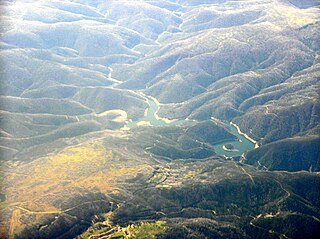
Salt Springs Reservoir is a reservoir in the eastern portions of Amador County and Calaveras County of California in the Sierra Nevada about 30 miles (48 km) east-northeast of Jackson. The reservoir is in the Eldorado National Forest at an elevation of 3,900 feet (1,200 m).
The Bridge River Power Project is a hydroelectric power development in the Canadian province of British Columbia, located in the Lillooet Country between Whistler and Lillooet. It harnesses the power of the Bridge River, a tributary of the Fraser, by diverting it through a mountainside to the separate drainage basin of Seton Lake, utilizing a system of three dams, four powerhouses and a canal.

Lake Natoma is a small lake in the western United States, along the lower American River, between Folsom and Nimbus Dams in Sacramento County, California. The lake is located within the Folsom Lake State Recreation Area which is responsible for maintaining the facilities and bike trails surrounding the lake. Lake Natoma is located 15 miles east of Sacramento, and has 500 surface acres of water. The total length of lake Natoma is 4 miles.

Lost Creek Lake is a reservoir located on the Rogue River in Jackson County, Oregon, United States. The lake is impounded by William L. Jess Dam which was constructed by the U.S. Army Corps of Engineers in 1977 for flood control and fisheries enhancement. The lake and dam were the first completed elements of the multi-purpose Rogue River Basin Project, consisting of Lost Creek Lake, Applegate Lake and the Elk Creek project. The lake is located approximately 27 miles (43 km) northeast of Medford.

Croton Dam is an earth-filled embankment dam and powerplant complex on the Muskegon River in Croton Township, Newaygo County, Michigan. It was built in 1907 under the direction of William D. Fargo by the Grand Rapids - Muskegon Power Company, a predecessor of Consumers Energy. The 40-foot-high (12 m) dam impounds 7.2 billion U.S. gallons (6 billion imp. gal/27 billion L) of water in its 1,209-acre (489 ha) reservoir and is capable of producing 8,850 kilowatts at peak outflow. It was listed on the National Register of Historic Places in 1979.
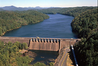
Apalachia Dam is a hydroelectric dam on the Hiwassee River in Cherokee County, in the U.S. state of North Carolina. The dam is the lowermost of three dams on the river owned and operated by the Tennessee Valley Authority, which built the dam in the early 1940s to provide emergency power for aluminum production during World War II. While the dam is in North Carolina, an 8.3-mile (13.4 km) underground conduit carries water from the dam's reservoir to the powerhouse located 12 miles (19 km) downstream across the state line in Polk County, Tennessee. The dam and associated infrastructure were listed on the National Register of Historic Places in 2017.

Hardy Dam is an earth-filled embankment dam and powerplant complex on the Muskegon River in Big Prairie Township, Newaygo County, Michigan. At the time of its completion, it was the largest earthen dam in North America east of the Mississippi. Its impoundment forms a lake with over 50 miles of shoreline. The dam impounds a reservoir with a surface area of 4,000 acres and its power plant has an installed capacity of 31.5 MW.
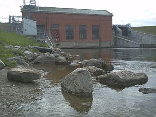
Ocoee Dam Number 2 is a hydroelectric dam on the Ocoee River in Polk County in the U.S. state of Tennessee. The dam impounds the Ocoee No. 2 Reservoir and is one of four dams on the Toccoa/Ocoee River owned and operated by the Tennessee Valley Authority. It was completed in 1913.

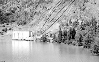
Stave Falls Dam is a dual-dam power complex on the Stave River in Stave Falls, British Columbia, Canada. The dam was completed in 1912 for the primary purpose of hydroelectric power production. To increase the capacity of Stave Lake, the dam was raised in 1925 and the Blind Slough Dam constructed in an adjacent watercourse 500 m (1,600 ft) to the north, which was the site of the eponymous Stave Falls. In 2000, the dam's powerhouse was replaced after a four-year upgrade. The powerhouse was once British Columbia's largest hydroelectric power source and is a National Historic Site of Canada.
Cooke Dam is a hydro-electric dam on the Au Sable River in Michigan. It was listed on the National Register of Historic Places in 1996 as the Cooke Hydroelectric Plant.

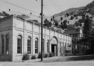
The Devil's Gate-Weber Hydroelectric Power Plant was built in 1909-1910 on the Weber River in northeastern Utah, United States, about 10 miles (16 km) southeast of Ogden. It was built by the Utah Light and Railway Company under the direction of E.H. Harriman, a director of the Union Pacific Railroad. It was one of the first powerplants in Utah designed to feed an electrical grid rather than as a source of power of a single locality.

The Big Creek Hydroelectric Project is an extensive hydroelectric power scheme on the upper San Joaquin River system, in the Sierra Nevada of central California. The project is owned and operated by Southern California Edison (SCE). The use and reuse of the waters of the San Joaquin River, its South Fork, and the namesake of the project, Big Creek – over a vertical drop of 6,200 ft (1,900 m) – have over the years inspired a nickname, "The Hardest Working Water in the World".

Wishon Dam is a dam in Fresno County, California in the Sierra National Forest, in the Sierra Nevada Mountain Range. It impounds the North Fork Kings River to form Wishon Reservoir.

The Stairs Station Hydroelectric Power Plant was built in 1894-1895 in Big Cottonwood Canyon, about 8 miles (13 km) southeast of Salt Lake City, Utah. The plant comprises the powerhouse, switchyard, penstocks, and a pipeline. A dam next to the site is associated with the Granite Power Plant farther downstream, and is part of neither historic district. The powerhouse is the only remaining building associated with the plant. It is an example of an intact high-head generating plant from the late 19th century.
The Granite Hydroelectric Power Station was built in 1896–1897 at the mouth of Big Cottonwood Canyon, about 6 miles (9.7 km) southeast of Salt Lake City, Utah, United States(in what is now eastern Cottonwood Heights. The plant comprises the powerhouse, transformer house, a wooden conduit, penstocks, and a small dam. Like the Stairs Station upstream, it represents an intact high-head generating plant from the late 19th century.

The Eklutna Power Plant, also referred to as Old Eklutna Power Plant, is a historic hydroelectric power plant on the Eklutna River in Anchorage, Alaska. Located about 5 miles (8.0 km) downstream of the more modern new Eklutna Power Plant, it was built in 1928-29 to provide electrical power to the growing city, and served as its primary power source until 1956. The facilities include two dams, a tunnel and penstock, and a powerhouse. The main dam, Eklutna Dam, located at the northwestern end of Eklutna Lake, was built in 1941 to replace a series of temporary structures built after an earthen dam failed before the plant began operation. The diversion dam, a concrete arch dam, is located 7 miles (11 km) downstream from the lake, and provides facilities for diverting water into the tunnel. The tunnel is 1,900 feet (580 m) long, and is terminated in a penstock, a structure designed to raise the water pressure. The powerhouse is a concrete-and-steel structure completed in 1929. The diversion dam removal was completed in 2018 to allow for the passage of salmon.

Mio Dam is a hydro-electric dam located on the Au Sable River in Michigan capable of generating 4.96 MW of electric power. It was the 4th of 6 dams built by Consumers Power between 1906 and 1924 along the Au Sable River and is the furthest upstream of the six. The dam was completed in 1916. The Mio Hydroelectric Plant consists of an embankment on each side connected by a spillway. Located North of the spillway is the powerhouse and outdoor substation. Public access to Mio Pond is provided via a boat ramp maintained by Consumers Energy, and portage facilities are also provided allowing canoes and kayaks access to bypass the dam. Portage the dam on the right using the cement stairs then carry down a gravel road with a canoe slide on the down river side of the dam. The Mio Dam powerhouse continues to operate with the same turbines and generators that were installed over a century ago.


