
Rio Arriba County is a county in the U.S. state of New Mexico. As of the 2020 census, the population was 40,363. Its county seat is Tierra Amarilla. Its northern border is the Colorado state line.

Santa Clara Pueblo ″Singing Water Village″, also known as ″Village of Wild Roses″ is a census-designated place (CDP) in Rio Arriba County, New Mexico, United States and a federally recognized tribe of Native American Pueblo people.
Aztec is a city in, and the county seat of, San Juan County, New Mexico, United States. The city population was 6,126 as of the 2022 census. The Aztec Ruins National Monument is located on the north side of the city.

Farmington is a city in San Juan County in the U.S. state of New Mexico. As of the 2020 census the city had a population of 46,624 people. Farmington makes up one of the four metropolitan statistical areas (MSAs) in New Mexico.

Bandelier National Monument is a 33,677-acre (13,629 ha) United States National Monument near Los Alamos in Sandoval and Los Alamos counties, New Mexico. The monument preserves the homes and territory of the Ancestral Puebloans of a later era in the Southwest. Most of the pueblo structures date to two eras, dating between 1150 and 1600 AD.

Chaco Culture National Historical Park is a United States National Historical Park in the American Southwest hosting a concentration of pueblos. The park is located in northwestern New Mexico, between Albuquerque and Farmington, in a remote canyon cut by the Chaco Wash. Containing the most sweeping collection of ancient ruins north of Mexico, the park preserves one of the most important pre-Columbian cultural and historical areas in the United States.

Navajo National Monument is a National Monument located within the northwest portion of the Navajo Nation territory in northern Arizona, which was established to preserve three well-preserved cliff dwellings of the Ancestral Puebloan people: Keet Seel, Betatakin, and Inscription House. The monument is high on the Shonto plateau, overlooking the Tsegi Canyon system, west of Kayenta, Arizona. It features a visitor center with a museum, three short self-guided trails, two small campgrounds, and a picnic area.
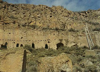
The Puye Cliff Dwellings are the ruins of an abandoned pueblo, located in Santa Clara Canyon on Santa Clara Pueblo land near Española, New Mexico. The site was declared a National Historic Landmark in 1966.

This is a list of properties and districts in New Mexico that are on the National Register of Historic Places. There are more than 1,100 listings. Of these, 46 are National Historic Landmarks. There are listings in each of the state's 33 counties.

Canyons of the Ancients National Monument is a national monument protecting an archaeologically significant landscape located in the southwestern region of the U.S. state of Colorado. The monument's 176,056 acres (71,247 ha) are managed by the Bureau of Land Management, as directed in the presidential proclamation which created the site on June 9, 2000. Canyons of the Ancients National Monument is part of the National Landscape Conservation System, better known as the National Conservation Lands. This system comprises 32 million acres managed by the Bureau of Land Management to conserve, protect, and restore these nationally significant landscapes recognized for their outstanding cultural, ecological, and scientific values. Canyons of the Ancients encompasses and surrounds three of the four separate sections of Hovenweep National Monument, which is administered by the National Park Service. The monument was proclaimed in order to preserve the largest concentration of archaeological sites in the United States, primarily Ancestral Puebloan ruins. As of 2022, over 8,500 individual archeological sites had been documented within the monument.

Dinétah is the traditional homeland of the Navajo tribe of Native Americans. In the Navajo language, the word "Dinétah" means "among the people" or "among the Navajo". In the geographical sense, Dinétah encompasses a large area of northwestern New Mexico, southwestern Colorado, southeastern Utah, and northeastern Arizona. The boundaries are inexact, and are generally marked by mountain peaks which correspond to the four cardinal directions.
The Christmas Tree Ruin is an archaeological site containing a Navajo pueblito, a defensive structure built in a high cliff wall approximately 200 feet above the floor of Gobernador Canyon in northwestern New Mexico, United States. The ruin, which is believed to have been built by the Navajo, dates to the 18th century, and was probably used for defensive, storage, and habitation purposes.

The Adolfo Canyon Site is an archaeological site containing a Navajo pueblito located in Rio Arriba County, New Mexico, United States. The site is situated on a rock outcrop overlooking Adolfo Canyon. The site consists of a three-room, single story pueblito, and extensive midden area, and six forked stick hogans on the crest of a ridge.
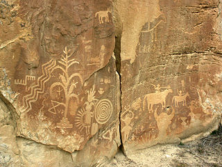
The Crow Canyon Archaeological District is located in the heart of the Dinétah region of the American Southwest in Rio Arriba and San Juan counties in New Mexico approximately 30 miles southeast of the city of Farmington. This region, known to be the ancestral homeland of the Navajo people, contains the most extensive collection of Navajo and Ancient Pueblo petroglyphs or rock art in the United States. Etched into rock panels on the lower southwest walls of the canyon are petroglyphs or rock art depicting what is believed to be ceremonial scenes and symbolic images that represent the stories, traditions and beliefs of the Navajo people. Dating back to the 16th, 17th, and 18th centuries, the petroglyphs have maintained their integrity despite the environmental conditions of the canyon and the effects of tourism. Among the ruins in the Crow Canyon Archaeological District there is also a cluster of Navajo defensive structures or pueblitos, which were built in the 18th century during periods of conflict with the Utes and the beginnings of Spanish Colonialism.

The term Navajo Pueblitos, also known as Dinétah Pueblitos, refers to a class of archaeological sites that are found in the northwestern corner of the American state of New Mexico. The sites generally consist of relatively small stone and timber structures which are believed to have been built by the Navajo people in the late 17th and early 18th centuries.
Old Fort Ruin is an archaeological site located in Rio Arriba County, northwestern New Mexico, United States, on lands owned by the State of New Mexico. The site consists of the ruins of a Navajo pueblito and associated hogans and artifacts. The site is included on the National Register of Historic Places in New Mexico.

The Trail of the Ancients is a collection of National Scenic Byways located in the U.S. Four Corners states of Utah, Colorado, New Mexico, and Arizona. These byways comprise:

The Tsama Pueblo is a Tewa Pueblo ancestral site in an address-restricted area of Abiquiú, New Mexico. It was occupied from around 1250 until around 1500 and contained 1100 rooms. The site and others in the area were explored by Florence Hawley Ellis in the 1960s and 1970s. In 1983, it was listed on the National Register of Historic Places listings in Rio Arriba County, New Mexico. Tsama is located 3 miles (4.8 km) from the Poshuouinge site. The Sapawe site is closely related. In December 2008, The Archaeological Conservancy extended the Tsama Archaeological Preserve by 11.6523 acres, mostly cobble mulch garden plots which were likely once constructed by the residents of Tsama Pueblo.
Wide Ruins is a chapter of the Navajo Nation and a census-designated place (CDP) in Apache County, Arizona, United States. The population was 176 at the 2010 census.
The Trail of the Ancients is a New Mexico Scenic Byway to prehistoric archaeological and geological sites of northwestern New Mexico. It provides insight into the lives of the Ancestral Puebloans and the Navajo, Ute, and Apache peoples. Geological features include canyons, volcanic rock features, and sandstone buttes. Several of the sites are scenic and wilderness areas with recreational opportunities.
