
Eureka is a city in Juab County, Utah, United States. It is part of the Provo–Orem metropolitan area. The population was 669 at the 2010 census, down from 766 in 2000.

The Anaconda Copper Mine was a large copper mine in Butte, Montana that closed operations in 1947 and was eventually consumed by the Berkeley Pit, a vast open-pit mine. Originally a silver mine, it was bought for $30,000 in 1881 by an Irish immigrant named Marcus Daly from Michael Hickey, a Civil War veteran, and co-owner Charles X. Larabie. From this beginning Daly, along with partners George Hearst, James Ben Ali Haggin and Lloyd Tevis, created the Anaconda Copper Mining Company, which ultimately became a global mining enterprise that would go on to mine 18 billion pounds of copper over 100 years. At the height of The Anaconda Copper Mining Company, it consisted of the Anaconda and other Butte mines, a smelter at Anaconda, Montana, processing plants in Great Falls, Montana, the American Brass Company, and many other properties spanning multiple countries.

Kennecott Utah Copper LLC (KUC), a division of Rio Tinto Group, is a mining, smelting, and refining company. Its corporate headquarters are located in South Jordan, Utah. Kennecott operates the Bingham Canyon Mine, one of the largest open-pit copper mines in the world in Bingham Canyon, Salt Lake County, Utah. The company was first formed in 1898 as the Boston Consolidated Mining Company. The current corporation was formed in 1989. The mine and associated smelter produce 1% of the world's copper.
The Birmingham District is a geological area in the vicinity of Birmingham, Alabama, where the raw materials for making steel, limestone, iron ore, and coal are found together in abundance. The district includes Red Mountain, Jones Valley, and the Warrior and Cahaba coal fields in Central Alabama.

The Deer Creek Dam and Reservoir hydroelectric facilities are on the Provo River in western Wasatch County, Utah, United States, about 16 miles (26 km) northeast of Provo. The dam is a zoned earthfill structure 235 feet (72 m) high with a crest length of 1,304 ft (397 m). The dam contains 2,810,000 cubic yards of material and forms a reservoir of 152,570 acre-foot (188,190,000 m3) capacity. Construction began in May 1938 and was completed in 1941. The reservoir supplies water for agricultural, municipal, and industrial use. Recreational activities on and around the reservoir include boating, fishing, camping, swimming and water skiing.

The Bingham Canyon Mine, more commonly known as Kennecott Copper Mine among locals, is an open-pit mining operation extracting a large porphyry copper deposit southwest of Salt Lake City, Utah, in the Oquirrh Mountains. The mine is the largest man-made excavation, and deepest open-pit mine in the world, which is considered to have produced more copper than any other mine in history – more than 19,000,000 short tons. The mine is owned by Rio Tinto Group, a British-Australian multinational corporation. The copper operations at Bingham Canyon Mine are managed through Kennecott Utah Copper Corporation which operates the mine, a concentrator plant, a smelter, and a refinery. The mine has been in production since 1906, and has resulted in the creation of a pit over 0.75 miles (1,210 m) deep, 2.5 miles (4 km) wide, and covering 1,900 acres. It was designated a National Historic Landmark in 1966 under the name Bingham Canyon Open Pit Copper Mine. The mine experienced a massive landslide in April 2013 and a smaller slide in September 2013.
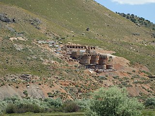
The Tintic Standard Reduction Mill—also known as the Tintic Mill or Harold Mill—built in 1920, and only operating from 1921 to 1925, is an abandoned refinery or concentrator located on the west slope of Warm Springs Mountain on the southern edge of Genola, Utah, United States. In 2002, the Utah Department of Environmental Quality tested the soil and found it contained high levels of arsenic and lead, which can lead to serious health problems and even death.

Mercur is a historical hard rock mining ghost town in Tooele County, Utah, United States. In 1891, it became the site of the first successful use of the cyanide process of gold extraction in the United States, the dominant metallurgy today. Its elevation above sea level is approximately 2,042 m. The nearby Mercur Gold Mine was re-opened by Barrick Gold in 1985, with mining operations again coming to an end in 1997. The reclamation and restoration project was set to continue up to 2010.

The Uinta Basin is a physiographic section of the larger Colorado Plateaus province, which in turn is part of the larger Intermontane Plateaus physiographic division. It is also a geologic structural basin in eastern Utah, east of the Wasatch Mountains and south of the Uinta Mountains. The Uinta Basin is fed by creeks and rivers flowing south from the Uinta Mountains. Many of the principal rivers flow into the Duchesne River which feeds the Green River—a tributary of the Colorado River. The Uinta Mountains forms the northern border of the Uinta Basin. They contain the highest point in Utah, Kings Peak, with a summit 13,528 feet above sea level. The climate of the Uinta Basin is semi-arid, with occasionally severe winter cold.

Frisco is a ghost town in Beaver County, Utah, United States. It was an active mining camp from 1879 to 1929. At its peak in 1885, Frisco was a thriving town of 6,000 people.

The Zion – Mount Carmel Highway is a 25-mile (40 km) long road in Washington and Kane counties in southern Utah, United States, that is listed on the National Register of Historic Places and is a National Historic Civil Engineering Landmark.

Standardville is a ghost town in Carbon County, Utah, United States. Standardville was established after coal was discovered in the area in 1912. The layout of the town was so well-planned, it became the "standard" for all mining towns to follow, which resulted in the town name of Standardville. In 1922, a group of striking miners killed a mine guard and wounded two miners before escaping. In 1930, 20 miners were killed in a mine explosion caused by carbon monoxide gas. In 1950, the mine shut down and people began to relocate elsewhere. A couple families remained until the 1970s, after which Standardville was abandoned.
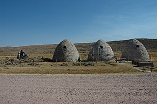
The Piedmont Charcoal Kilns in Piedmont, Wyoming, are a remnant of a once-extensive charcoal-making industry in southwestern Wyoming. The kilns were built by Moses Byrne around 1869 near the Piedmont Station along the Union Pacific Railroad. The three surviving beehive-shaped kilns were built of local sandstone about 30 feet (9.1 m) in circumference and about 30 feet (9.1 m) high, with 24-inch-thick (61 cm) walls. A granite marker reads:
Charcoal Kilns were built by Moses Byrne, 1869, to supply the pioneer smelters in the Utah Valley.
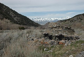
The Charcoal Kilns near Eureka, Utah were listed on the National Register of Historic Places in 1979. The listing included two charcoal kilns that each are about six feet in diameter and four feet deep, built out of stone. They are believed to have been built or used to support the Wyoming Smelter in 1871.
The Lime Kilns located at the western end of Homansville Canyon near Eureka, Utah, were part of a lime quarry in the 1920s. The kilns were listed on the National Register of Historic Places in 1979. The listing included one contributing site and two contributing structures: two lime kilns that are approximately 8 feet (2.4 m) in diameter and 30 to 40 feet deep.

The Birch Creek Charcoal Kilns are a group of beehive-shaped clay charcoal kilns near Leadore, Idaho, built in 1886. They were listed on the National Register of Historic Places in 1972.
The Soldier Creek Kilns near Stockton, Utah date from about 1873, the time of their construction, and were in use up until about 1899. Also known as the Waterman Coking Ovens, they were listed on the National Register of Historic Places (NRHP) in 1980. The listing included 14 contributing structures over 30 acres (12 ha).
The Tybo Charcoal Kilns are a pair of charcoal kilns located 4 miles (6.4 km) north of Tybo, Nevada. Both kilns are 30 feet (9.1 m) tall and 25 feet (7.6 m) in diameter and were built from rocks and mud. The kilns each have three openings: a top opening, a door at ground level, and a rear window with a ramp for wood wagons. The kilns were among 15 built in 1874 for the Tybo Consolidated Company. The company, which mined the region's silver, used charcoal to fuel its smelting furnace. To acquire its fuel, it imported wood from nearby hills, which it then converted to charcoal in the kilns.

The San Juan and New York Smelting Company, was a mineral smelter located below Smelter Mountain right in front of Durango, Colorado, operating from 1882 to 1930, processing Coke, Lead, Copper, Silver, and Gold from mines all over La Plata County, San Juan County, and elsewhere in the Southwestern Colorado Region generally serviced by railroad. It was later reinstated during World War II by the U. S. Vanadium Corporation for production of large amounts of Uranium that would be utilized in the Manhattan Project. From 1963 on the smelter sat dormant until the U.S. Department of Energy cleaned up the site from 1985 to 1987 due to concerns regarding toxic mineral tailings/radioactive waste, as well as the Colorado Department of Public Health and Environment suing ASARCO or damages to natural resources in 1983. Today the site is now the City of Durango's dog park and also considered a popular local hike.
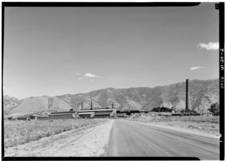
The International Smelting and Refining Company was a subsidiary of Anaconda Copper that operated primarily out of the International Smelter near Tooele, Utah. The International Smelter began operation in 1910 as a copper producer handling ores from Bingham Canyon and was expanded into a lead smelting operation in 1912. Copper smelting finished at International in 1946, and the lead smelter shut down in January 1972. The closure of the smelter would lead to the associated Tooele Valley Railway to be shut down ten years later in 1982. The company also handled several other Anaconda owned interests. After the shut down of several of the International Smelting sites, environmental reclamation has been performed by Anaconda Copper's successor company ARCO and the EPA Superfund program.


