
Pima County is a county in the south central region of the U.S. state of Arizona. As of the 2010 census, the population was 980,263, making it Arizona's second-most populous county. The county seat is Tucson, where most of the population is centered. The county is named after the Pima Native Americans who are indigenous to this area.

Casas Adobes is an unincorporated community and census-designated place (CDP) located in the northern metropolitan area of Tucson, Arizona. The population was 66,795 at the 2010 census. Casas Adobes is situated south and southwest of the town of Oro Valley, and west of the community of Catalina Foothills.

Sacaton is a census-designated place (CDP) in Pinal County, Arizona, United States. The population was 1,584 at the 2000 census. It is the capital of the Gila River Indian Community.

Casa Grande Ruins National Monument, in Coolidge, Arizona, just northeast of the city of Casa Grande, preserves a group of Hohokam structures dating to the Classic Period.

Organ Pipe Cactus National Monument is a U.S. national monument and UNESCO biosphere reserve located in extreme southern Arizona that shares a border with the Mexican state of Sonora. The park is the only place in the United States where the senita and organ pipe cactus grow wild. Along with this species, many other types of cacti and other desert flora native to the Yuma Desert section of the Sonoran Desert region grow in the park. Organ Pipe Cactus National Monument is 517 sq mi (1,340 km2) in size. In 1976 the monument was declared a Biosphere Reserve by UNESCO, and in 1977 95% of Organ Pipe Cactus was declared a wilderness area.

Pipe Spring National Monument is a United States National Monument located in the U.S. state of Arizona, rich with American Indian, early explorer, and Mormon pioneer history. Administered by the National Park Service, Pipe Spring was listed on the National Register of Historic Places on October 15, 1966, and the boundaries of the Pipe Spring National Monument Historic District were expanded in October 2000.

This is a directory of properties and districts listed on the National Register of Historic Places in Arizona. There are about fourteen hundred listed sites in the state, and each of its fifteen counties has at least ten listings on the National Register. Forty-seven of the state's sites are further designated as National Historic Landmarks.
Fort Bowie was a 19th-century outpost of the United States Army located in southeastern Arizona near the present day town of Willcox, Arizona. The remaining buildings and site are now protected as Fort Bowie National Historic Site.

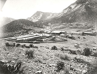
Kentucky Camp is a ghost town and former mining camp along the Arizona Trail in Pima County, Arizona, United States, near the community of Sonoita. The Kentucky Camp Historic District is listed on the National Register of Historic Places and has been since 1995. As it is located within Coronado National Forest, the United States Forest Service is responsible for the upkeep of the remaining buildings within the Kentucky Camp Historic District.
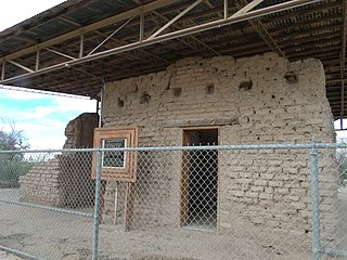
Mission Los Santos Ángeles de Guevavi was founded by Jesuit missionary Fathers Kino and Salvatierra in 1691 as La Misión de San Gabriel de Guevavi, a district headquarters in what is now Arizona, near Tumacácori. Subsequent missionaries called it San Rafael and San Miguel, resulting in the common historical name of Los Santos Ángeles de Guevavi.

Oak Grove Butterfield Stage Station is located in the western foothills of the Laguna Mountains, in northern San Diego County, California. It is located on State Route 79, 13 miles (21 km) northwest of Warner Springs and Warner's Ranch. The station was built on the site of Camp Wright, an 1860s Civil War outpost.

The Faraway Ranch Historic District is part of the Chiricahua National Monument in southern Arizona, and preserves an area associated with the final conflicts with the local Apache, one of the last frontier settlements, and in particular, its association with the people who promoted the establishment of the Chiricahua National Monument. Faraway Ranch is located in Bonita Canyon, which lies at an approximate altitude of 5160 feet and opens in a southwesterly direction into the Sulphur Springs Valley.
The Bates Well Ranch, also known as the Bates Well, Growler Well, Gray Ranch and El Veit, was one of the fifteen ranches and line camps in the Gray family cattle business in the Sonoran Desert country north of the US-Mexico border in Pima County, Arizona. Operating for nearly 60 years, the ranch is now part of Organ Pipe Cactus National Monument.

The Dos Lomitas Ranch, also known as the Rattlesnake Ranch, Blankenship Well and the Gray Ranch, was the first of fifteen ranches and line camps in the Gray family cattle business in the Sonoran Desert country north of the US-Mexico border in Arizona. The ranch is now part of Organ Pipe Cactus National Monument. The period of significance begins for the district with the purchase of the water rights for the ranch in 1919 and ends with the death with the last of the three Gray sons, Robert, Jr., in 1976, and the subsequent removal of the last of the Gray's cattle from the monument.

El Camino del Diablo, also known as El Camino del Muerto, Sonora Trail, Sonoyta-Yuma Trail, Yuma-Caborca Trail, and Old Yuma Trail, is a historic 250-mile (400 km) road that passes through some of the most remote and inhospitable terrain of the Sonoran Desert in Pima County and Yuma County, Arizona. The name refers to the harsh, unforgiving conditions on the trail.
Fort Lowell was a United States Army post active from 1873 to 1891 on the outskirts of Tucson, Arizona. Fort Lowell was the successor to Camp Lowell, an earlier Army installation. The Army chose a location just south of the confluence of the Tanque Verde and Pantano creeks, at the point where they form the Rillito River, due to the year-round supply of water during that period. The Hohokam natives had chosen the site centuries earlier, presumably for the same reason. To this day, shards of Hohokam pottery can still be found in the area. The Army claimed a military reservation that encompassed approximately eighty square miles and extended east toward the Rincon Mountains.
This is a list of the National Register of Historic Places listings in Organ Pipe Cactus National Monument.
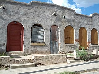
Barrio Libre is a neighborhood in Tucson, Arizona notable for its existence as a relatively unchanged 19th-century Hispanic neighborhood of close-packed row houses. Houses in the barrio are typically adobe with very plain detailing, reflecting the area's history as a district of townhouses for Mexican ranching families. The district includes more than 200 contributing structures, with relatively few non-conforming buildings. The district is bounded by 14th and 18th streets to the north and south, and by Stone and Osborne to the east and west. Meyer Avenue runs through the center of the barrio.

Quitobaquito Springs are springs in Organ Pipe Cactus National Monument in Pima County, Arizona. The name is of Tohono O'odham origin meaning 'house ring spring'. The area has been populated for at least 16,000 years. It lies at an elevation of 1,152 feet (351 m), west of the south end of the Quitobaquito Hills, along the border of the United States with Mexico. The only US populations of the endangered Quitobaquito pupfish, the Sonoyta mud turtle, the desert caper, and the Howarth's white butterfly are found here. The Quitabaquito tryonia is an endemic resident of the springs.


