Galactic coordinate system

Last updated
Artist's depiction of the Milky Way Galaxy, showing the galactic longitude. A vector matching the plane of the galaxy, at 0deg longitude, notably has the Galactic Center and intersects arms directly beyond. Far less of the galaxy lies at all points with opposing 180deg longitude Artist's impression of the Milky Way (updated - annotated).jpg
Artist's depiction of the Milky Way Galaxy, showing the galactic longitude. A vector matching the plane of the galaxy, at 0° longitude, notably has the Galactic Center and intersects arms directly beyond. Far less of the galaxy lies at all points with opposing 180° longitude

The galactic coordinate system is a celestial coordinate system in spherical coordinates, with the Sun as its center
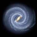
, the primary direction aligned with the approximate center of the Milky Way Galaxy, and the fundamental plane parallel to an approximation of the galactic plane but offset to its north. It uses the right-handed convention, meaning that coordinates are positive toward the north and toward the east in the fundamental plane. [1]

Contents

Spherical coordinates

Galactic longitude

The galactic coordinates use the Sun as the origin. Galactic longitude (l) is measured with primary direction from the Sun to the center of the galaxy in the galactic plane, while the galactic latitude (b) measures the angle of the object above the galactic plane. Galactic coordinates.JPG
The galactic coordinates use the Sun as the origin. Galactic longitude (l) is measured with primary direction from the Sun to the center of the galaxy in the galactic plane, while the galactic latitude (b) measures the angle of the object above the galactic plane.

Longitude (symbol l) measures the angular distance of an object eastward along the galactic equator from the Galactic Center. Analogous to terrestrial longitude, galactic longitude is usually measured in degrees (°).

Galactic latitude

Latitude (symbol b) measures the angle of an object northward of the galactic equator (or midplane) as viewed from Earth. Analogous to terrestrial latitude, galactic latitude is usually measured in degrees (°).

Definition

The first galactic coordinate system was used by William Herschel in 1785. A number of different coordinate systems, each differing by a few degrees, were used until 1932, when Lund Observatory assembled a set of conversion tables that defined a standard galactic coordinate system based on a galactic north pole at RA 12h40m, dec +28° (in the B1900.0 epoch convention) and a 0° longitude at the point where the galactic plane and equatorial plane intersected. [1]

In 1958, the International Astronomical Union (IAU) defined the galactic coordinate system in reference to radio observations of galactic neutral hydrogen through the hydrogen line, changing the definition of the Galactic longitude by 32° and the latitude by 1.5°. [1] In the equatorial coordinate system, for equinox and equator of 1950.0, the north galactic pole is defined at right ascension 12h49m, declination +27.4°, in the constellation Coma Berenices, with a probable error of ±0.1°. [2] Longitude 0° is the great semicircle that originates from this point along the line in position angle 123° with respect to the equatorial pole. The galactic longitude increases in the same direction as right ascension. Galactic latitude is positive towards the north galactic pole, with a plane passing through the Sun and parallel to the galactic equator being 0°, whilst the poles are ±90°. [3] Based on this definition, the galactic poles and equator can be found from spherical trigonometry and can be precessed to other epochs; see the table.

J2000.0 equatorial coordinates approximating the galactic reference points [1]
  Right ascension Declination Constellation
North Pole
+90° latitude
12h51.4m+27.13° Coma Berenices
(near 31 Com)
South Pole
−90° latitude
0h51.4m−27.13° Sculptor
(near NGC 288)
Center
0° longitude
17h45.6m−28.94° Sagittarius
(in Sagittarius A)
Anticenter
180° longitude
5h45.6m+28.94° Auriga
(near HIP 27180)
Galactic north pole.png
Galactic north
Galactic south pole.png
Galactic south
Galactic zero longitude.png
Galactic center

The IAU recommended that during the transition period from the old, pre-1958 system to the new, the old longitude and latitude should be designated lI and bI while the new should be designated lII and bII. [3] This convention is occasionally seen. [4]

Radio source Sagittarius A*, which is the best physical marker of the true Galactic Center, is located at 17h45m40.0409s, −29°00′28.118″ (J2000). [2] Rounded to the same number of digits as the table, 17h45.7m, −29.01° (J2000), there is an offset of about 0.07° from the defined coordinate center, well within the 1958 error estimate of ±0.1°. Due to the Sun's position, which currently lies 56.75±6.20  ly north of the midplane, and the heliocentric definition adopted by the IAU, the galactic coordinates of Sgr A* are latitude +0°07′12″ south, longitude 04′06″. Since as defined the galactic coordinate system does not rotate with time, Sgr A* is actually decreasing in longitude at the rate of galactic rotation at the sun, Ω, approximately 5.7 milliarcseconds per year (see Oort constants).

Conversion between equatorial and galactic coordinates

An object's location expressed in the equatorial coordinate system can be transformed into the galactic coordinate system. In these equations, α is right ascension, δ is declination. NGP refers to the coordinate values of the north galactic pole and NCP to those of the north celestial pole. [5]

The reverse (galactic to equatorial) can also be accomplished with the following conversion formulas.

Where:

Rectangular coordinates

In some applications use is made of rectangular coordinates based on galactic longitude and latitude and distance. In some work regarding the distant past or future the galactic coordinate system is taken as rotating so that the x-axis always goes to the centre of the galaxy. [6]

There are two major rectangular variations of galactic coordinates, commonly used for computing space velocities of galactic objects. In these systems the xyz-axes are designated UVW, but the definitions vary by author. In one system, the U axis is directed toward the Galactic Center (l = 0°), and it is a right-handed system (positive towards the east and towards the north galactic pole); in the other, the U axis is directed toward the galactic anticenter (l = 180°), and it is a left-handed system (positive towards the east and towards the north galactic pole). [7]

The anisotropy of the star density in the night sky makes the galactic coordinate system very useful for coordinating surveys, both those that require high densities of stars at low galactic latitudes, and those that require a low density of stars at high galactic latitudes. For this image the Mollweide projection has been applied, typical in maps using galactic coordinates. Milky Way infrared.jpg
The anisotropy of the star density in the night sky makes the galactic coordinate system very useful for coordinating surveys, both those that require high densities of stars at low galactic latitudes, and those that require a low density of stars at high galactic latitudes. For this image the Mollweide projection has been applied, typical in maps using galactic coordinates.

In the constellations

The galactic equator runs through the following constellations: [8]

See also

Related Research Articles

<span class="mw-page-title-main">Latitude</span> Geographic coordinate specifying north–south position

In geography, latitude is a coordinate that specifies the north–south position of a point on the surface of the Earth or another celestial body. Latitude is given as an angle that ranges from −90° at the south pole to 90° at the north pole, with 0° at the Equator. Lines of constant latitude, or parallels, run east–west as circles parallel to the equator. Latitude and longitude are used together as a coordinate pair to specify a location on the surface of the Earth.

<span class="mw-page-title-main">Gyrocompass</span> Type of non-magnetic compass based on the rotation of the Earth

A gyrocompass is a type of non-magnetic compass which is based on a fast-spinning disc and the rotation of the Earth to find geographical direction automatically. A gyrocompass makes use of one of the seven fundamental ways to determine the heading of a vehicle. A gyroscope is an essential component of a gyrocompass, but they are different devices; a gyrocompass is built to use the effect of gyroscopic precession, which is a distinctive aspect of the general gyroscopic effect. Gyrocompasses, such as the fibre optic gyrocompass are widely used to provide a heading for navigation on ships. This is because they have two significant advantages over magnetic compasses:

<span class="mw-page-title-main">Astronomical coordinate systems</span> System for specifying positions of celestial objects

In astronomy, coordinate systems are used for specifying positions of celestial objects relative to a given reference frame, based on physical reference points available to a situated observer. Coordinate systems in astronomy can specify an object's position in three-dimensional space or plot merely its direction on a celestial sphere, if the object's distance is unknown or trivial.

<span class="mw-page-title-main">Equatorial coordinate system</span> Celestial coordinate system used to specify the positions of celestial objects

The equatorial coordinate system is a celestial coordinate system widely used to specify the positions of celestial objects. It may be implemented in spherical or rectangular coordinates, both defined by an origin at the centre of Earth, a fundamental plane consisting of the projection of Earth's equator onto the celestial sphere, a primary direction towards the vernal equinox, and a right-handed convention.

<span class="mw-page-title-main">Ecliptic coordinate system</span> Celestial coordinate system used to describe Solar System objects

In astronomy, the ecliptic coordinate system is a celestial coordinate system commonly used for representing the apparent positions, orbits, and pole orientations of Solar System objects. Because most planets and many small Solar System bodies have orbits with only slight inclinations to the ecliptic, using it as the fundamental plane is convenient. The system's origin can be the center of either the Sun or Earth, its primary direction is towards the vernal (March) equinox, and it has a right-hand convention. It may be implemented in spherical or rectangular coordinates.

<span class="mw-page-title-main">Proper motion</span> Measure of observed changes in the apparent locations of stars

Proper motion is the astrometric measure of the observed changes in the apparent places of stars or other celestial objects in the sky, as seen from the center of mass of the Solar System, compared to the abstract background of the more distant stars.

<span class="mw-page-title-main">Supergalactic coordinate system</span>

The supergalactic plane is part of a reference frame for the supercluster of galaxies that contains the Milky Way galaxy.

In geodesy, conversion among different geographic coordinate systems is made necessary by the different geographic coordinate systems in use across the world and over time. Coordinate conversion is composed of a number of different types of conversion: format change of geographic coordinates, conversion of coordinate systems, or transformation to different geodetic datums. Geographic coordinate conversion has applications in cartography, surveying, navigation and geographic information systems.

<span class="mw-page-title-main">Galactic plane</span> Plane on which the majority of a disk-shaped galaxys mass lies

The galactic plane is the plane on which the majority of a disk-shaped galaxy's mass lies. The directions perpendicular to the galactic plane point to the galactic poles. In actual usage, the terms galactic plane and galactic poles usually refer specifically to the plane and poles of the Milky Way, in which Planet Earth is located.

The solar zenith angle is the zenith angle of the sun, i.e., the angle between the sun’s rays and the vertical direction. It is the complement to the solar altitude or solar elevation, which is the altitude angle or elevation angle between the sun’s rays and a horizontal plane. At solar noon, the zenith angle is at a minimum and is equal to latitude minus solar declination angle. This is the basis by which ancient mariners navigated the oceans.

<span class="mw-page-title-main">Scale (map)</span> Ratio of distance on a map to the corresponding distance on the ground

The scale of a map is the ratio of a distance on the map to the corresponding distance on the ground. This simple concept is complicated by the curvature of the Earth's surface, which forces scale to vary across a map. Because of this variation, the concept of scale becomes meaningful in two distinct ways.

<span class="mw-page-title-main">Universal Transverse Mercator coordinate system</span> Map projection system

The Universal Transverse Mercator (UTM) is a map projection system for assigning coordinates to locations on the surface of the Earth. Like the traditional method of latitude and longitude, it is a horizontal position representation, which means it ignores altitude and treats the earth surface as a perfect ellipsoid. However, it differs from global latitude/longitude in that it divides earth into 60 zones and projects each to the plane as a basis for its coordinates. Specifying a location means specifying the zone and the x, y coordinate in that plane. The projection from spheroid to a UTM zone is some parameterization of the transverse Mercator projection. The parameters vary by nation or region or mapping system.

The n-vector representation is a three-parameter non-singular representation well-suited for replacing geodetic coordinates for horizontal position representation in mathematical calculations and computer algorithms.

Polar alignment is the act of aligning the rotational axis of a telescope's equatorial mount or a sundial's gnomon with a celestial pole to parallel Earth's axis.

Vincenty's formulae are two related iterative methods used in geodesy to calculate the distance between two points on the surface of a spheroid, developed by Thaddeus Vincenty (1975a). They are based on the assumption that the figure of the Earth is an oblate spheroid, and hence are more accurate than methods that assume a spherical Earth, such as great-circle distance.

In spherical astronomy, the parallactic angle is the angle between the great circle through a celestial object and the zenith, and the hour circle of the object. It is usually denoted q. In the triangle zenith—object—celestial pole, the parallactic angle will be the position angle of the zenith at the celestial object. Despite its name, this angle is unrelated with parallax. The parallactic angle is zero or 180° when the object crosses the meridian.

<span class="mw-page-title-main">Geodetic coordinates</span> Geographic coordinate system

Geodetic coordinates are a type of curvilinear orthogonal coordinate system used in geodesy based on a reference ellipsoid. They include geodetic latitude (north/south) ϕ, longitude (east/west) λ, and ellipsoidal heighth. The triad is also known as Earth ellipsoidal coordinates.

<span class="mw-page-title-main">Galactic quadrant</span> One of four circular sectors of the Milky Way galaxy

A galactic quadrant, or quadrant of the Galaxy, is one of four circular sectors in the division of the Milky Way Galaxy.

<span class="mw-page-title-main">Position of the Sun</span> Calculating the Suns location in the sky at a given time and place

The position of the Sun in the sky is a function of both the time and the geographic location of observation on Earth's surface. As Earth orbits the Sun over the course of a year, the Sun appears to move with respect to the fixed stars on the celestial sphere, along a circular path called the ecliptic.

Astronomical nutation is a phenomenon which causes the orientation of the axis of rotation of a spinning astronomical object to vary over time. It is caused by the gravitational forces of other nearby bodies acting upon the spinning object. Although they are caused by the same effect operating over different timescales, astronomers usually make a distinction between precession, which is a steady long-term change in the axis of rotation, and nutation, which is the combined effect of similar shorter-term variations.

References

  1. 1 2 3 4 Blaauw, A.; Gum, C.S.; Pawsey, J.L.; Westerhout, G. (1960). "The new IAU system of galactic coordinates (1958 revision)". Monthly Notices of the Royal Astronomical Society . 121 (2): 123. Bibcode:1960MNRAS.121..123B. doi: 10.1093/mnras/121.2.123 .
  2. 1 2 Reid, M.J.; Brunthaler, A. (2004). "The Proper Motion of Sagittarius A*". The Astrophysical Journal. 616 (2): 874, 883. arXiv: astro-ph/0408107 . Bibcode:2004ApJ...616..872R. doi:10.1086/424960. S2CID   16568545.
  3. 1 2 James Binney, Michael Merrifield (1998). Galactic Astronomy. Princeton University Press. pp. 30–31. ISBN   0-691-02565-7.
  4. For example in Kogut, A.; et al. (1993). "Dipole Anisotropy in the COBE Differential Microwave Radiometers First-Year Sky Maps". Astrophysical Journal . 419: 1. arXiv: astro-ph/9312056 . Bibcode:1993ApJ...419....1K. doi:10.1086/173453.
  5. Carroll, Bradley; Ostlie, Dale (2007). An Introduction to Modern Astrophysics (2nd ed.). Pearson Addison-Wesley. pp. 900–901. ISBN   978-0805304022.
  6. For example Bobylev, Vadim V. (March 2010). "Searching for Stars Closely Encountering with the Solar System". Astronomy Letters. 36 (3): 220–226. arXiv: 1003.2160 . Bibcode:2010AstL...36..220B. doi:10.1134/S1063773710030060. S2CID   118374161.
  7. Johnson, Dean R.H.; Soderblom, David R. (1987). "Calculating galactic space velocities and their uncertainties, with an application to the Ursa Major group". Astronomical Journal. 93: 864. Bibcode:1987AJ.....93..864J. doi:10.1086/114370.
  8. "SEDS Milky Way Constellations".