Georgetown, Pennsylvania | |
---|---|
Coordinates: 41°13′35″N75°52′19″W / 41.22639°N 75.87194°W | |
Country | United States |
State | Pennsylvania |
County | Luzerne |
Township | Wilkes-Barre |
Area | |
• Total | 0.7 sq mi (1.9 km2) |
• Land | 0.7 sq mi (1.9 km2) |
• Water | 0 sq mi (0 km2) |
Population (2010) | |
• Total | 1,640 |
• Density | 2,200/sq mi (860/km2) |
Time zone | UTC-5 (Eastern (EST)) |
• Summer (DST) | UTC-4 (EDT) |
ZIP code | 18702 |
Area code | 570 |
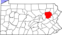
Georgetown is a census-designated place (CDP) in Wilkes-Barre Township, Luzerne County, Pennsylvania, United States, adjacent to the city of Wilkes-Barre. The CDP population was 1,640 at the 2010 census. [1]
Georgetown is located at 41°13′35″N75°52′19″W / 41.22639°N 75.87194°W . [2]
According to the United States Census Bureau, the CDP has a total area of 0.73 square miles (1.9 km2), all land. Georgetown occupies most of the southwestern half of Wilkes-Barre Township and is bisected by I-81/PA 309. Exit 165 of I-81 is located at the southwestern edge of the CDP. The city of Wilkes-Barre is to the northwest.
It is in the Wilkes-Barre Area School District. [3]
The Back Mountain is a region and former census-designated place (CDP) in Luzerne County, Pennsylvania, United States. It is near the cities of Scranton and Wilkes-Barre. The population was 33,551 as of 2016. The region has a total area of 117.59 square miles (304.6 km2). The area was not delineated as a CDP for the 2010 census. The name "Back Mountain" refers to the area's location behind the mountain ridge forming the northwest side of the Wyoming Valley. The area includes the townships of Dallas, Franklin, Jackson, Kingston, Lake, and Lehman. The region also includes the boroughs of Dallas and Harveys Lake. Each township and borough is independently governed.
Bear Creek Township is a township in Luzerne County, Pennsylvania, United States. The township has a total area of 67.8 square miles (176 km2), making it is the largest municipality in Luzerne County. The population was 2,752 at the 2020 census.
Hanover Township is a township in Luzerne County, Pennsylvania. As of the 2020 census, the population was 11,424, making it the most populous township in the county.
Mountain Top is an unincorporated area and census-designated place (CDP) in Luzerne County, Pennsylvania, United States. As of the 2010 census, its population was 10,982.
Plains Township is a township in Luzerne County, Pennsylvania, United States. The population was 9,816 at the 2020 census. The municipality is the birthplace of Chicago White Sox hall of famer Ed Walsh and John J. Yeosock, a United States Army general who commanded the 3rd U.S. Army during Operation Desert Shield and Operation Desert Storm. Mohegan Pennsylvania is a casino in Plains Township.
Wilkes-Barre Township is a township with home rule status in Luzerne County, Pennsylvania, United States. It is adjacent to the city of Wilkes-Barre. The population of the township was 3,219 at the 2020 census.
Shavertown is a census-designated place (CDP) in Kingston Township, Luzerne County, Pennsylvania, United States. It lies approximately 7 miles (11 km) northwest of the city of Wilkes-Barre and 24 miles (39 km) southwest of Scranton. The population of the CDP was 2,019 at the 2010 census.
Trucksville is a census-designated place (CDP) in Kingston Township, Luzerne County, Pennsylvania, United States. The population was 2,152 at the 2010 census.
Pardeesville is a census-designated place (CDP) in Hazle Township, Luzerne County, Pennsylvania, United States. The population was 572 at the 2010 census.
Sheatown is a census-designated place (CDP) in Newport Township, Luzerne County, Pennsylvania, United States. It is adjacent to the west side of the city of Nanticoke. The population of Sheatown was 671 at the 2010 census.
West Nanticoke is a census-designated place (CDP) in Plymouth Township, Luzerne County, Pennsylvania, United States, across the Susquehanna River from the city of Nanticoke. The population of the CDP was 749 at the 2010 census.
Harleigh is a census-designated place (CDP) in Hazle Township, Luzerne County, Pennsylvania, United States, north of the city of Hazleton. The CDP population was 1,104 at the 2010 census.
Plains is a census-designated place (CDP) in Plains Township, Luzerne County, Pennsylvania, United States. The population of the CDP was 4,335 at the 2010 census, out of 9,961 in the entire township.
Inkerman is a census-designated place (CDP) in Jenkins Township, Luzerne County, Pennsylvania, United States. The population was 1,819 at the 2010 census.
Browntown is a census-designated place (CDP) in Pittston Township, Luzerne County, Pennsylvania, United States, adjacent to Pittston City. The CDP population was 1,418 at the 2010 census.
Chase is a census-designated place (CDP) in Jackson Township, Luzerne County, Pennsylvania, United States. The CDP population was 978 at the 2010 census.
Hickory Hills is a census-designated place (CDP) in Foster Township, Luzerne County, Pennsylvania, southwest of the borough of White Haven. The CDP population was 562 at the 2010 census.
Hilldale is a census-designated place (CDP) in Plains Township, Luzerne County, Pennsylvania, United States. The population was 1,246 at the time of the 2010 census.
Hudson is a census-designated place (CDP) in Plains Township, Luzerne County, Pennsylvania, United States. The population was 1,443 at the 2010 census.
Upper Exeter is a census-designated place (CDP) in Exeter Township, Luzerne County, Pennsylvania, United States. The population was 707 at the 2010 census.