Glenorchy is a suburb of Hobart, in the state of Tasmania, Australia. Glenorchy is bound by the River Derwent to the east, Mount Wellington to the west, Hobart City to the south and Brighton to the north. The city officially begins at Creek Road New Town, in Hobart's northern suburbs, and includes, Moonah, Derwent Park, Lutana, Goodwood, Montrose, Rosetta, Berriedale, Chigwell, Claremont and Austins Ferry. It is the seat of the local government area of the same name, the City of Glenorchy.

Glenorchy City Council is a local government body in Tasmania, and one of the five municipalities that constitutes the Greater Hobart Area. The Glenorchy local government area has a population of 47,636, covering the suburbs north of central Hobart on the western shore of the Derwent River, including its namesake suburb, Glenorchy.
Claremont is a rural / residential locality in the local government areas (LGA) of Glenorchy (75%) and Derwent Valley (25%) in the Hobart and South-east LGA regions of Tasmania. The locality is about 6 kilometres (3.7 mi) north of the town of Glenorchy. The 2016 census recorded a population of 7750 for the state suburb of Claremont.

The Division of Denison was an Australian electoral division in Tasmania, before being replaced by the Division of Clark as part of a 2016–17 redistribution.

Guilford Young College is a Roman Catholic senior secondary college, with campuses located in the Hobart suburbs of Glenorchy and Hobart City in Tasmania, Australia. The College provides education to students in Year 11 and Year 12, offering more than 100 Tasmanian Certificate of Education (TCE), pre-tertiary and Vocational Education and Training (VET) courses. The college is named in honour of Sir Guilford Young who served as the eighth Archbishop of Hobart from 1955 to 1988.
Shoreline Plaza is a suburban shopping centre located on the corner of Clarence St and South Arm Highway in the suburb of Howrah on Hobart's Eastern Shore.

Moonah is a residential locality in the local government area (LGA) of Glenorchy in the Hobart LGA region of Tasmania. The locality is about 3 kilometres (1.9 mi) south-east of the town of Glenorchy. The 2016 census recorded a population of 5421 for the state suburb of Moonah. It is a suburb in the city of Hobart, located approximately 5 km north of the central business district of Hobart, and lying directly north of the inner city suburb New Town.
Claremont Village is a small sub-regional shopping centre located on the corner of Main Road and Box Hill Road, in Claremont, Tasmania.
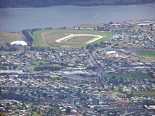
Derwent Barracks is an Australian Army barracks in the Hobart suburb of Glenorchy, near the Elwick Racecourse and Hobart Showgrounds. It is named after the nearby Derwent River. It is the home of several Army Reserve units including:

Elizabeth Street is the major street which runs southeast to northwest through the city and suburbs of Hobart, Tasmania, Australia. It was named by the Governor of New South Wales from 1810 to 1821, Lachlan Macquarie, after his wife Elizabeth Macquarie. It starts at Sullivans Cove and runs northwesterly through the CBD of Hobart and the North Hobart shopping district including the State Cinema, and changes to become New Town Road at the intersection with Augusta Road in New Town.
Rosny Park is a suburb of Hobart, Tasmania, located in the City of Clarence on the eastern shore of the Derwent River. It is about five kilometres from the city centre of Hobart. Rosny Park is the commercial twin of its residential namesake, Rosny.
Rosny Park Transit Mall is a section of Bligh Street in Rosny Park located between Eastlands Shopping Centre and Rosny Park Post Office which is currently closed to normal traffic to allow it to be devoted as a Metro Tasmania bus interchange. The transit mall is the section of Bligh Street located between Bayfield Street and Ross Avenue. Clarence City Council has indicated it intends to re-open the road to general traffic with works expected to be finished by December 2012.

The Hobart Bus Mall is a section of Elizabeth Street which serves as Metro Tasmania's primary bus terminus in Hobart's CBD. It is utilised by thousands of commuters every day, bringing city workers into Hobart from outlying suburbs, and the neighbouring cities of Clarence and Glenorchy, as well as nearby Richmond, Cambridge and Kingborough. The mall is the section of Elizabeth Street, located between Macquarie Street, and Collins Street. There are also several stops located in nearby Franklin Square.

Cadbury's Chocolate Factory is the largest chocolate factory in the Southern Hemisphere, producing a company-record of over 60,000 tonnes of chocolate in 2021. Established at Claremont, Tasmania in 1921, the factory and surrounding model village estate marked Cadbury's first business expansion outside the United Kingdom. Cadbury's Claremont is currently owned by the multinational conglomerate Mondelēz International, which purchased Cadbury in 2010.

Goodwood Road is a 4-lane link road that connects the City of Glenorchy to the City of Clarence in the greater area of Hobart, Tasmania. Using the Bowen Bridge the road travels over the River Derwent in semi-highway road layout. The Road starts 10 km north of the Hobart CBD near the Hobart Showground on the Brooker Highway at Glenorchy, from there it travels east past the Elwick Racecourse, over the Bowen Bridge and connects to the East Derwent Highway at Otago. While the route the road takes is used far less than other major arterial roads in Hobart, commuters often depend on the road when major incidents occur on other major roads throughout Hobart.
Elwick Road is a major arterial road that runs through the northern suburbs of Hobart, Tasmania. The Road is the major link road between the Main Road and the Brooker Highway that connects to Glenorchy. The Road Passes through residential areas.
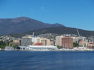
Hobart City Centre is a suburb surrounded by metropolitan Hobart, which comprises the original settlement, the central business district, and other built-up areas. It is the oldest part of Hobart and includes many of the city's important institutions and landmarks, such as Parliament, the Supreme Court, Franklin Square, the Elizabeth Street Mall, the Royal Hobart Hospital, the Theatre Royal, Odeon Theatre, State Library, the NAB Building, the Museum, and the Cenotaph. The city centre is located in the local government areas of the City of Hobart.

Elizabeth Street Mall is a pedestrian street mall in Hobart, Tasmania. It is located on Elizabeth Street between Collins Street and Liverpool Street. It is the largest shopping area in the Hobart city centre. It is also a busy meeting place and busking area.

The Division of Clark is an Australian Electoral Division in the state of Tasmania, first contested at the 2019 federal election.