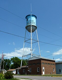
Good Thunder, Minnesota

Last updated

Good Thunder, Minnesota
2009-0805-GoodThunder.jpg
Water tower
Blue Earth County Minnesota Incorporated and Unincorporated areas Good Thunder Highlighted.svg
Location of Good Thunder, Minnesota
Coordinates: 44°00′24″N94°04′13″W / 44.00667°N 94.07028°W / 44.00667; -94.07028
CountryUnited States
State Minnesota
County Blue Earth
PlattedApril 1871
Incorporated March 2, 1893
Government
  TypeMayor – Council
   Mayor Robert Anderson
Area
[1]
  Total0.63 sq mi (1.62 km2)
  Land0.63 sq mi (1.62 km2)
  Water0.00 sq mi (0.00 km2)
Elevation
[2]
1,004 ft (306 m)
Population
 (2020) [3]
  Total560
  Estimate 
(2022) [4]
566
  Density893.14/sq mi (344.99/km2)
Time zone UTC–6 (Central (CST))
  Summer (DST) UTC–5 (CDT)
ZIP Code
56037
Area code 507
FIPS code 27-24506
GNIS feature ID2394927 [2]
Sales tax 7.375% [5]
Website goodthundermn.com

Good Thunder is a city in Blue Earth County, Minnesota, United States, situated along the Maple River. The population was 560 at the 2020 census. [3]

Contents

History

Good Thunder, after whom the town is named Good Thunder.jpg
Good Thunder, after whom the town is named

Originally, this area was a part of the Winnebago Reservation from 1855 to 1859. John Graham established a hotel in what is now the town in 1870. [6] When the railroad arrived in Minnesota, the town began as an agricultural commerce center.

Good Thunder was platted in April 1871, and named for a Winnebago chief (who was also known as Wakuntchapinka). [7] [8] [9] Chief Good Thunder was well known to the early white towns people, and he had converted to Christianity. [7]

The town was incorporated on March 2, 1893. [8] [10]

Geography

According to the United States Census Bureau, the city has a total area of 0.64 square miles (1.66 km2), all land. [11]

Former State Highway 66; and County Roads 1 and 10 are three of the main routes in the community.

Demographics

Historical population
CensusPop.Note
1880 149
1900 505
1910 419−17.0%
1920 46410.7%
1930 452−2.6%
1940 4571.1%
1950 4764.2%
1960 468−1.7%
1970 4894.5%
1980 56014.5%
1990 5610.2%
2000 5925.5%
2010 583−1.5%
2020 560−3.9%
2022 (est.)566 [4] 1.1%
U.S. Decennial Census [12]
2020 Census [3]

Good Thunder is part of the MankatoNorth Mankato Metropolitan Statistical Area.

2010 census

Someone living alone who was 65 years of age or older. The average household size was 2.73 and the average family size was 3.21.

As of the census of 2010, there were 583 people, 227 households, and 155 families living in the city. The population density was 910.9 inhabitants per square mile (351.7/km2). There were 242 housing units at an average density of 378.1 per square mile (146.0/km2). The racial makeup of the city was 98.1% White, 1.4% African American, 0.2% Native American, and 0.3% from two or more races. Hispanic or Latino of any race were 1.0% of the population.

There were 227 households, of which 36.1% had children under the age of 18 living with them, 53.7% were married couples living together, 8.8% had a female householder with no husband present, 5.7% had a male householder with no wife present, and 31.7% were non-families. 24.2% of all households were made up of individuals, and 7.9% had someone living alone who was 65 years of age or older. The average household size was 2.57 and the average family size was 3.09.

The median age in the city was 34 years. 27.4% of residents were under the age of 18; 7.8% were between the ages of 18 and 24; 29.7% were from 25 to 44; 24% were from 45 to 64; and 10.8% were 65 years of age or older. The gender makeup of the city was 49.4% male and 50.6% female.

2000 census

As of the census of 2000, there were 592 people, 217 households, and 161 families living in the city. The population density was 945.7 inhabitants per square mile (365.1/km2). There were 233 housing units at an average density of 372.2 per square mile (143.7/km2). The racial makeup of the city was 97.64% White, 0.17% African American, 0.17% Native American, 0.34% Asian, and 1.69% from two or more races.

There were 217 households, out of which 43.8% had children under the age of 18 living with them, 63.6% were married couples living together, 8.3% had a female householder with no husband present, and 25.8% were non-families. 24.0% of all households were made up of individuals, and 12.0% had In the city, the population was spread out, with 32.8% under the age of 18, 8.8% from 18 to 24, 31.3% from 25 to 44, 16.4% from 45 to 64, and 10.8% who were 65 years of age or older. The median age was 31 years. For every 100 females, there were 94.1 males. For every 100 females age 18 and over, there were 90.4 males.

The median income for a household in the city was $42,500, and the median income for a family was $45,469. Males had a median income of $31,375 versus $21,146 for females. The per capita income for the city was $14,524. About 12.4% of families and 13.0% of the population were below the poverty line, including 16.7% of those under age 18 and 19.3% of those age 65 or over.

See also

Related Research Articles

Lyra Township is a township in Blue Earth County, Minnesota, United States. The population was 378 as of the 2000 census.

<span class="mw-page-title-main">Backus, Minnesota</span> City in Minnesota, United States

Backus is a city in Cass County, Minnesota, United States. The population was 262 at the 2020 census. It is part of the Brainerd Micropolitan Statistical Area.

<span class="mw-page-title-main">Chickamaw Beach, Minnesota</span> City in Minnesota, United States

Chickamaw Beach is a city in Cass County, Minnesota, United States. The population was 128 at the 2020 census. It is part of the Brainerd Micropolitan Statistical Area.

<span class="mw-page-title-main">Lake Shore, Minnesota</span> City in Minnesota, United States

Lake Shore is a city in Cass County, Minnesota, United States. The population was 1,056 at the 2020 census. It is part of the Brainerd Micropolitan Statistical Area.

Lima Township is a township in Cass County, Minnesota, United States. The population was 111 as of the 2000 census. Lima Township was probably named after Lima, Ohio.

<span class="mw-page-title-main">Remer, Minnesota</span> City in Minnesota, United States

Remer is a city in Cass County, Minnesota, United States. The population was 391 at the 2020 census. It is part of the Brainerd Micropolitan Statistical Area.

Remer Township is a township in Cass County, Minnesota, United States. The population was 183 as of the 2000 census. Remer Township was named for two brothers, E. N. and William P. Remer.

<span class="mw-page-title-main">Emily, Minnesota</span> City in Minnesota, United States

Emily is a city in Crow Wing County, Minnesota, United States. The population was 843 at the 2020 census. It is part of the Brainerd Micropolitan Statistical Area.

<span class="mw-page-title-main">Ironton, Minnesota</span> City in Minnesota, United States

Ironton is a city in Crow Wing County, Minnesota, United States. The population was 572 at the 2010 census. It is part of the Brainerd Micropolitan Statistical Area.

<span class="mw-page-title-main">Trommald, Minnesota</span> City in Minnesota, United States

Trommald is a city in Crow Wing County, Minnesota, United States. The population was 99 at the 2020 census. It is part of the Brainerd Micropolitan Statistical Area.

<span class="mw-page-title-main">Deer Creek, Minnesota</span> City in Minnesota, United States

Deer Creek is a city in Otter Tail County, Minnesota, United States. The population was 330 at the 2020 census.

<span class="mw-page-title-main">Erhard, Minnesota</span> City in Minnesota, United States

Erhard is a city in Otter Tail County, Minnesota, United States. The population was 132 at the 2020 census.

<span class="mw-page-title-main">Henning, Minnesota</span> City in Minnesota, United States

Henning is a city in Otter Tail County, Minnesota, United States. The population was 854 at the 2020 census.

<span class="mw-page-title-main">Richville, Minnesota</span> City in Minnesota, United States

Richville is a city in Otter Tail County, Minnesota, United States. The population was 77 as of the 2020 census.

<span class="mw-page-title-main">Burtrum, Minnesota</span> City in Minnesota, United States

Burtrum is a city in Todd County, Minnesota, United States. The population was 144 at the 2010 census. By the 2020 Decennial Census the population had declined to 123.

<span class="mw-page-title-main">Waldorf, Minnesota</span> City in Minnesota, United States

Waldorf is a city in Waseca County, Minnesota, United States. The population was 229 at the 2010 census.

<span class="mw-page-title-main">Grant, Minnesota</span> City in Minnesota, United States

Grant is a city in Washington County, Minnesota, and a suburb of St. Paul. The population was 4,096 at the time of the 2010 census.

<span class="mw-page-title-main">Darfur, Minnesota</span> City in the United States

Darfur is a city in Watonwan County, Minnesota, United States. The population was 108 at the 2010 census.

<span class="mw-page-title-main">Minnesota Lake, Minnesota</span> City in Minnesota, United States

Minnesota Lake is a city in Blue Earth and Faribault counties in the State of Minnesota. The population was 661 at the 2020 census. The bulk of the city is in Faribault County; a small part extends into Blue Earth County.

<span class="mw-page-title-main">Bellechester, Minnesota</span> City in Minnesota, United States

Bellechester is a city in Goodhue and Wabasha counties in the U.S. state of Minnesota. The population was 175 at the 2010 census. Most of Bellchester is in Goodhue County, with only a small part extending into Wabasha County.

References

  1. "2020 U.S. Gazetteer Files". United States Census Bureau. Retrieved July 24, 2022.
  2. 1 2 U.S. Geological Survey Geographic Names Information System: Good Thunder, Minnesota
  3. 1 2 3 "Explore Census Data". United States Census Bureau . Retrieved January 22, 2024.
  4. 1 2 "City and Town Population Totals: 2020-2022". United States Census Bureau. January 22, 2024. Retrieved January 22, 2024.
  5. "Good Thunder (MN) sales tax rate" . Retrieved January 22, 2024.
  6. Schrader, Julie (1990). The Heritage of Blue Earth County. Curtis Media Corporation. p. 214.
  7. 1 2 Upham, Warren (1920). Minnesota Geographic Names: Their Origin and Historic Significance. Minnesota Historical Society. p.  59.
  8. 1 2 Upham, Warren (1920). Collections of the Minnesota Historical Society. Vol. XVII. Minnesota Historical Society. Minnesota Historical Society. pp. 59–60.
  9. Johansen, Bruce E.; Jr, Donald A. Grinde (August 21, 1998). The Encyclopedia Of Native American Biography. Da Capo Press. p. 150. ISBN   978-0-306-80870-8.
  10. Upham, Warren (2001). Minnesota Place Names: A Geographical Encyclopedia. Minnesota Historical Society Press. p. 63. ISBN   978-0-87351-396-8.
  11. "U.S. Gazetteer files 2010". United States Census Bureau. Archived from the original on January 12, 2012. Retrieved November 13, 2012.
  12. United States Census Bureau. "Census of Population and Housing" . Retrieved June 4, 2015.