Hector, Minnesota

Last updated

Hector
Motto(s): 
"A great place to live, work and play!" [1]
Renville County Minnesota Incorporated and Unincorporated areas Hector Highlighted.svg
Location of Hector, Minnesota
Coordinates: 44°44′33″N94°42′52″W / 44.74250°N 94.71444°W / 44.74250; -94.71444
CountryUnited States
State Minnesota
County Renville
Founded1878
Organized1881
Government
   Mayor Daniel Edwards
Area
[2]
  Total1.81 sq mi (4.68 km2)
  Land1.81 sq mi (4.68 km2)
  Water0.00 sq mi (0.00 km2)
Elevation
[3]
1,083 ft (330 m)
Population
 (2020) [4]
  Total1,012
  Estimate 
(2022) [5]
1,002
  Density560.35/sq mi (216.31/km2)
Time zone UTC-6 (Central (CST))
  Summer (DST) UTC-5 (CDT)
ZIP code
55342
Area code 320
FIPS code 27-28124 [6]
GNIS feature ID2394344 [3]
Website hector.govoffice.com

Hector is a city in Renville County, Minnesota, United States. The population was 1,012 at the 2020 census. [4]

Contents

Geography

According to the United States Census Bureau, the city has a total area of 1.56 square miles (4.04 km2), all land. [7]

History

Hector was founded in 1878 when the Hastings and Dakota Railway Company constructed the railroad on the north side of the original town site. The ten-block town site survey was completed on September 14, 1878, on land owned by the Hastings and Dakota. [1]

The village was named after the township of Hector, which had been organized in June 1874. It was originally named Milford, but the name was changed when it was learned there was already another Milford in Minnesota. There was heated debate between those who favored the name Plainfield (after the stage stop and post office) and those who favored the name Hector, a township in New York on the east shore of Seneca Lake where many of the early settlers came from. Hector, New York, was named after the bravest of the ancient Trojan warriors whose story is told in Homer's "Iliad". [8] [9] (Later research showed the other Milford was actually in South Dakota, so the town could have been named Milford after all.)

Demographics

Historical population
CensusPop.Note
1880 196
1890 35480.6%
1900 65484.7%
1910 86632.4%
1920 830−4.2%
1930 8644.1%
1940 1,04420.8%
1950 1,19614.6%
1960 1,2978.4%
1970 1,178−9.2%
1980 1,2526.3%
1990 1,145−8.5%
2000 1,1661.8%
2010 1,151−1.3%
2020 1,012−12.1%
2022 (est.)1,002 [5] −1.0%
U.S. Decennial Census [10]
2020 Census [4]

2010 census

As of the census of 2010, there were 1,151 people, 513 households, and 322 families living in the city. The population density was 737.8 inhabitants per square mile (284.9/km2). There were 573 housing units at an average density of 367.3 per square mile (141.8/km2). The racial makeup of the city was 96.9% White, 0.6% Asian, 2.3% from other races, and 0.3% from two or more races. Hispanic or Latino of any race were 5.7% of the population.

There were 513 households, of which 29.2% had children under the age of 18 living with them, 48.3% were married couples living together, 10.1% had a female householder with no husband present, 4.3% had a male householder with no wife present, and 37.2% were non-families. 31.8% of all households were made up of individuals, and 18.8% had someone living alone who was 65 years of age or older. The average household size was 2.24 and the average family size was 2.78.

The median age in the city was 43.4 years. 23.8% of residents were under the age of 18; 6.5% were between the ages of 18 and 24; 21.5% were from 25 to 44; 27.9% were from 45 to 64; and 20.2% were 65 years of age or older. The gender makeup of the city was 48.9% male and 51.1% female.

2000 census

As of the census of 2000, there were 1,166 people, 509 households, and 320 families living in the city. The population density was 755.7 inhabitants per square mile (291.8/km2). There were 532 housing units at an average density of 344.8 per square mile (133.1/km2). The racial makeup of the city was 95.54% White, 4.03% from other races, and 0.43% from two or more races. Hispanic or Latino of any race were 5.23% of the population.

There were 509 households, out of which 28.9% had children under the age of 18 living with them, 50.3% were married couples living together, 9.4% had a female householder with no husband present, and 37.1% were non-families. 33.6% of all households were made up of individuals, and 20.4% had someone living alone who was 65 years of age or older. The average household size was 2.29 and the average family size was 2.90.

In the city, the population was spread out, with 25.5% under the age of 18, 6.4% from 18 to 24, 26.2% from 25 to 44, 21.6% from 45 to 64, and 20.2% who were 65 years of age or older. The median age was 40 years. For every 100 females, there were 85.4 males. For every 100 females age 18 and over, there were 84.9 males.

The median income for a household in the city was $33,000, and the median income for a family was $41,477. Males had a median income of $30,625 versus $22,159 for females. The per capita income for the city was $18,406. About 6.5% of families and 8.4% of the population were below the poverty line, including 11.4% of those under age 18 and 8.4% of those age 65 or over.

Notable people

Infrastructure

Transportation

U.S. Route 212 and Minnesota State Highway 4 are two of the main arterial routes in the city.

Hector Municipal Airport

The town is also served by rail via the Twin Cities and Western railroad's connection to both Minneapolis and St. Paul and points west. [11]

Related Research Articles

<span class="mw-page-title-main">New Albin, Iowa</span> City in Iowa, United States

New Albin is a city in Iowa Township, Allamakee County, Iowa, United States. It is the northeasternmost town in Iowa, located on the Mississippi River and the Minnesota border. The population was 432 at the time of the 2020 census.

<span class="mw-page-title-main">St. Clair, Minnesota</span> City in Minnesota, United States

St. Clair or Saint Clair is a city in Blue Earth County, Minnesota, United States, located along the Le Sueur River. The population was 750 at the 2020 census. It is part of the Mankato-North Mankato Metropolitan Statistical Area.

<span class="mw-page-title-main">Backus, Minnesota</span> City in Minnesota, United States

Backus is a city in Cass County, Minnesota, United States. The population was 250 at the 2010 census. It is part of the Brainerd Micropolitan Statistical Area.

<span class="mw-page-title-main">Clara City, Minnesota</span> City in Minnesota, United States

Clara City is a city in Chippewa County, Minnesota, United States. The population was 1,360 at the 2010 census.

<span class="mw-page-title-main">Brandon, Minnesota</span> City in Minnesota, United States

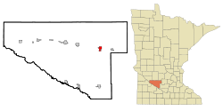
Brandon is a city in Douglas County, Minnesota, United States. The population was 501 at the 2020 census.

<span class="mw-page-title-main">Bricelyn, Minnesota</span> City in Minnesota, United States

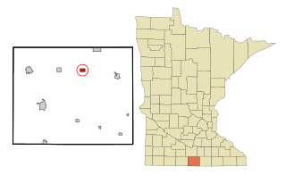
Bricelyn is a city in Faribault County, Minnesota, United States. The population was 365 at the 2010 census.

<span class="mw-page-title-main">Easton, Minnesota</span> City in Minnesota, United States

Easton is a city in Faribault County, Minnesota, United States. The population was 199 at the 2010 census.

<span class="mw-page-title-main">Corcoran, Minnesota</span> City in Minnesota, United States

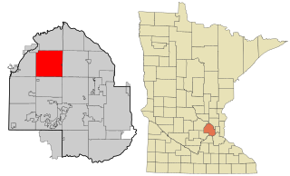
Corcoran is a rural city in Hennepin County, Minnesota, United States. The population was 5,379 at the 2010 census.

<span class="mw-page-title-main">Greenwood, Minnesota</span> City in Minnesota, United States

Greenwood is a community on Saint Albans Bay on Lake Minnetonka in Hennepin County, Minnesota, United States just northeast of the community of Excelsior, Minnesota. The population was 688 at the 2010 census.

<span class="mw-page-title-main">Orono, Minnesota</span> Rural city in Minnesota, United States

Orono is a city in Hennepin County, Minnesota, United States west of Minneapolis. Located on the north shore of Lake Minnetonka, Orono is one of the city’s most upscale and wealthiest neighborhoods and also known for its sparse suburban character and abundant wildlife.

<span class="mw-page-title-main">Caledonia, Minnesota</span> City in Minnesota, United States

Caledonia is a city and the county seat of Houston County, Minnesota, United States and is part of the La Crosse, Wisconsin Metropolitan Statistical Area. The population was 2,847 at the 2020 census.

Guthrie Township is a township in Hubbard County, Minnesota, United States. The population was 436 at the 2000 census.

<span class="mw-page-title-main">Cleveland, Minnesota</span> City in Minnesota, United States

Cleveland is a city in Le Sueur County, Minnesota, United States. The population was 719 at the 2010 census and 747 at the 2020 census.

<span class="mw-page-title-main">Courtland, Minnesota</span> City in Minnesota, United States

Courtland is a city in Nicollet County, Minnesota, United States. The population was 734 at the 2020 census. It is part of the Mankato-North Mankato Metropolitan Statistical Area.

<span class="mw-page-title-main">Oronoco, Minnesota</span> City in Minnesota, United States

Oronoco is a city in Olmsted County, Minnesota, United States, along the Middle Fork of the Zumbro River. The population was 1,802 at the 2020 census.

<span class="mw-page-title-main">Arlington, Minnesota</span> City in Minnesota, United States

Arlington is a city in Sibley County, Minnesota, United States. The population was 2,233 at the 2010 census.
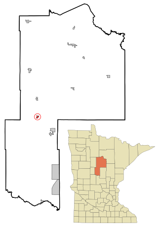
<span class="mw-page-title-main">St. Paul Park, Minnesota</span> City in Minnesota, United States

St. Paul Park or Saint Paul Park is a city in Washington County, Minnesota, United States. The population was 5,279 at the 2010 census. It is on the east bank of the Mississippi River, five miles (8 km) downstream from St. Paul.

<span class="mw-page-title-main">Butterfield, Minnesota</span> City in Minnesota, United States

Butterfield is a city in Watonwan County, Minnesota, United States. The population was 586 at the 2010 census.

<span class="mw-page-title-main">Comfrey, Minnesota</span> City in Minnesota, United States

Comfrey is a city in Brown and Cottonwood counties in the U.S. state of Minnesota. The population was 382 at the 2010 census. The majority of the people live in Brown County.

<span class="mw-page-title-main">Brooten, Minnesota</span> City in Minnesota, United States

Brooten is a city in Stearns and Pope counties in the U.S. state of Minnesota, United States. The population was 626 as of the 2020 census. Almost the entire city is within Stearns County, with a small portion in Pope County.

References

  1. 1 2 "City of Hector Minnesota". City of Hector Minnesota. Retrieved October 8, 2012.
  2. "2020 U.S. Gazetteer Files". United States Census Bureau. Retrieved July 24, 2022.
  3. 1 2 U.S. Geological Survey Geographic Names Information System: Hector, Minnesota
  4. 1 2 3 "Explore Census Data". United States Census Bureau . Retrieved November 22, 2023.
  5. 1 2 "City and Town Population Totals: 2020-2022". United States Census Bureau. November 22, 2023. Retrieved November 22, 2023.
  6. "American FactFinder". United States Census Bureau. Archived from the original on February 12, 2020. Retrieved January 31, 2008.
  7. "US Gazetteer files 2010". United States Census Bureau. Archived from the original on January 25, 2012. Retrieved November 13, 2012.
  8. "Profile for Hector, Minnesota, MN". ePodunk. Retrieved October 8, 2012.
  9. "Profile for Hector, New York, NY". ePodunk. Retrieved October 8, 2012.
  10. United States Census Bureau. "Census of Population and Housing" . Retrieved June 4, 2015.
  11. "TC&W Railroad Map | Largest MN Shortline Rail | MN Rail Map".