
The United States Army Corps of Engineers (USACE) is an engineer formation of the United States Army that has three primary mission areas: Engineer Regiment, military construction, and civil works. The day-to-day activities of the three mission areas are administered by a lieutenant general known as the commanding general/chief of engineers. The chief of engineers commands the Engineer Regiment, comprising combat engineer, rescue, construction, dive, and other specialty units, and answers directly to the Chief of Staff of the Army. Combat engineers, sometimes called sappers, form an integral part of the Army's combined arms team and are found in all Army service components: Regular Army, National Guard, and Army Reserve. Their duties are to breach obstacles; construct fighting positions, fixed/floating bridges, and obstacles and defensive positions; place and detonate explosives; conduct route clearance operations; emplace and detect landmines; and fight as provisional infantry when required. For the military construction mission, the commanding general is directed and supervised by the Assistant Secretary of the Army for installations, environment, and energy, whom the President appoints and the Senate confirms. Military construction relates to construction on military bases and worldwide installations.

Lake Oahe is a large reservoir behind Oahe Dam on the Missouri River; it begins in central South Dakota and continues north into North Dakota in the United States. The lake has an area of 370,000 acres (1,500 km2) and a maximum depth of 205 ft (62 m). By volume, it is the fourth-largest reservoir in the US. Lake Oahe has a length of approximately 231 mi (372 km) and has a shoreline of 2,250 mi (3,620 km). 51 recreation areas are located along Lake Oahe, and 1.5 million people visit the reservoir every year. The lake is named for the 1874 Oahe Indian Mission.

The Delaware Water Gap National Recreation Area is a 70,000 acres (28,000 ha) national recreation area along the middle section of the Delaware River in New Jersey and Pennsylvania stretching from the Delaware Water Gap northward in New Jersey to the state line near Port Jervis, New York, and in Pennsylvania to the outskirts of Milford.

The Bonnet Carré Spillway is a flood control operation in the Lower Mississippi Valley. Located in St. Charles Parish, Louisiana, about 12 miles (19 km) west of New Orleans, it allows floodwaters from the Mississippi River to flow into Lake Pontchartrain and thence into the Gulf of Mexico. The spillway was constructed between 1929 and 1931, following the Great Mississippi Flood of 1927, and has been designated as a National Historic Civil Engineering Landmark by the American Society of Civil Engineers.

Lewis and Clark Lake is a 31,400 acre (130 km²) reservoir located on the border of the U.S. states of Nebraska and South Dakota on the Missouri River. The lake is approximately 25 miles (40 km) in length with over 90 miles (140 km) of shoreline and a maximum water depth of 45 feet (14 m). The lake is impounded by Gavins Point Dam and is managed by the U.S. Army Corps of Engineers, Omaha District.
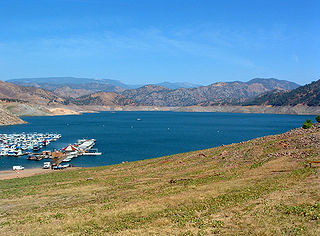
Pine Flat Lake is an artificial lake or reservoir in the Sierra Nevada foothills of eastern Fresno County, California on the western north-south border to the Sierra- and Sequoia National Forests, about 30 mi (48 km) east of Fresno. The lake is managed by the U.S. Army Corps of Engineers (USACE) and is open to boaters, campers & hikers.
Isabella Dam is an embankment dam located in the Kern River Valley, about halfway down the Kern River course, between the towns of Kernville and Lake Isabella in Kern County, California.

Canyon Lake is a reservoir on the Guadalupe River in the Texas Hill Country in the United States. Canyon Lake is a U.S. Army Corps of Engineers reservoir formed on the Guadalupe River in Comal County by Canyon Dam, which is located about sixteen miles northwest of New Braunfels. The dam, lake, and all adjacent property are managed by the U.S. Army Corps Of Engineers. Water rights, waste water treatment, and hydroelectric generating facilities are managed by the Guadalupe-Blanco River Authority. Construction of the dam began in 1958 and was completed in 1964. The reservoir serves to provide flood control and water supply for the communities downstream from the dam. The lake is also a popular recreational destination.

Mansfield Hollow Lake is a reservoir resting on the border of Windham County and Tolland County, Connecticut. The reservoir provides drinking water for Willimantic and helps control flooding in the 159-square-mile Thames River watershed. It was created by the Mansfield Hollow Dam and is entirely contained within Mansfield Hollow State Park and the Mansfield Hollow Wildlife Area. Designed and constructed by the United States Army Corps of Engineers, the dam substantially reduces flooding along the Quinebaug, Shetucket, and Thames rivers. Construction of the project began in 1949 with completion in 1952 at a cost of US$6.5 million. The Mansfield Hollow reservoir is located within the Shetucket River Watershed and is part of the Thames River Basin. Access to the site is available from US Route 6 and State Route 195. The damsite, covering an area of 25 acres (10 ha), was listed on the National Register of Historic Places in 2003.

Coralville Lake is an artificial lake in Johnson County, Iowa, United States, formed by the Coralville Dam, a dam built from 1949 to 1958 on the Iowa River upstream from the city of Coralville, Iowa.

Copper Falls State Park is a 3,068-acre (1,242 ha) state park in Wisconsin. The park contains a section of the Bad River and its tributary the Tylers Forks, which flow through a gorge and drop over several waterfalls. Old Copper Culture Indians and later European settlers mined copper in the area. The state park was created in 1929 and amenities were developed by the Civilian Conservation Corps and the Works Progress Administration. In 2005 the park was listed on the National Register of Historic Places as a site with 10 contributing properties.

Tully Lake, of Royalston, Massachusetts, is a 1,262-acre (511 ha) reservoir and flood control project constructed by the United States Army Corps of Engineers (USACE) in 1949 for 1.6 million dollars. The project prevents flooding of the greater Connecticut River and Millers River valleys and provides a variety of recreational opportunities, including a campground operated by The Trustees of Reservations. Tully Lake is an important link in the 22-mile (35 km) Tully Trail.

Buck Creek State Park is a 4,016-acre (1,625 ha) public recreation area in Clark County, Ohio, in the United States, that is leased by the state of Ohio from the U.S. Army Corps of Engineers. The state park's main feature is the C. J. Brown Reservoir, a flood control reservoir created by the USACE on Buck Creek as part of a flood control system in the Ohio River drainage basin. The park offers year-round recreation including camping, boating, hunting, fishing, swimming, picnicking, and hiking.

Carters Lake is a man-made reservoir located on the Coosawattee River in the Blue Ridge Mountains in Gilmer and Murray counties in the U.S. state of Georgia. It is the state's deepest lake.

Gathright Dam is an earthen and rolled rock-fill embankment dam on the Jackson River 19 miles (31 km) north of Covington, Virginia. The dam is 257 feet (78 m) tall and 1,310 feet (400 m) long and has a controlled spillway within the structure's southern portion. It creates Lake Moomaw, which has a normal volume of 40 billion US gallons (150,000,000 m3). The dam serves flood control and recreational purposes and is operated by the U.S. Army Corps of Engineers.

The Pequonnock River is a 16.7-mile-long (26.9 km) waterway in eastern Fairfield County, Connecticut. Its watershed is located in five communities, with the majority of it located within Monroe, Trumbull, and Bridgeport. The river has a penchant for flooding, particularly in spring since the removal of a retention dam in Trumbull in the 1950s. There seems to be a sharp difference of opinion among historians as to just what the Indian word Pequonnock signifies. Some insist it meant cleared field or open ground; others are sure it meant broken ground; while a third group is certain it meant place of slaughter or place of destruction.
West Thompson Lake is a 200-acre lake in Thompson, Windham County, Connecticut.

The Mojave Forks Dam, most often known as the Mojave River Dam, is an earth-fill dry dam across the Mojave River in San Bernardino County, California in the United States. Completed in 1974 by the U.S. Army Corps of Engineers (USACE), the dam is located at the confluence of the West Fork Mojave River and Deep Creek, and can store approximately 179,400 acre⋅ft (221,300,000 m3) of water.
The Potomac River basin reservoir projects were U.S. Army Corps of Engineers programs that sought to regulate the flow of the Potomac River to control flooding, to assure a reliable water supply for Washington, D.C., and to provide recreational opportunities. Beginning in 1921 the Corps studied a variety of proposals for an ambitious program of dam construction on the Potomac and its tributaries, which proposed as many as sixteen major dam and reservoir projects. The most ambitious proposals would have created a nearly continuous chain of reservoirs from tidewater to Cumberland, Maryland. The 1938 program was focused on flood control, on the heels of a major flood in 1936. The reformulated 1963 program focused on water supply and quality, mitigating upstream pollution from sewage and coal mine waste.


