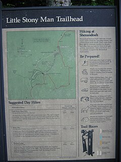
A trailhead is the point at which a trail begins, where the trail is often intended for hiking, biking, horseback riding, or off-road vehicles. Modern trailheads often contain rest rooms, maps, sign posts and distribution centers for informational brochures about the trail and its features, and parking areas for vehicles and trailers.
High Point is a mountain peak within High Point State Park on the border of Wantage Township and Montague Township, Sussex County, New Jersey, United States. Located in the portion of the state known as the Skylands, it is the highest elevation in the state, with a peak elevation of 1,803 feet. The closest city is Port Jervis, New York,which lies to the northwest. Besides being the highest peak in New Jersey, High Point is also the highest peak of the Kittatinny Mountains. Three states – New Jersey, New York, and Pennsylvania – can be seen from the top.

The Sangre de Cristo Mountains are the southernmost subrange of the Rocky Mountains. They are located in southern Colorado and northern New Mexico in the United States. The mountains run from Poncha Pass in South-Central Colorado, trending southeast and south, ending at Glorieta Pass, southeast of Santa Fe, New Mexico. The mountains contain a number of fourteen thousand foot peaks in the Colorado portion, as well as all the peaks in New Mexico which are over thirteen thousand feet.
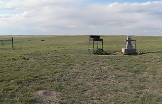
Panorama Point also known as Constable Mountain, is the highest natural point in Nebraska, at an elevation of 5,429 feet (1,655 m) above sea level. It is located in southwestern Kimball County, near the point where Nebraska and Wyoming meet on Colorado's northern boundary. Despite its name and elevation, Panorama Point is not a mountain or a hill; it is merely a low rise on the High Plains. A stone marker, giving the elevation at 5,424 feet (1,653 m), and a guest register are located at the summit of the drive. From the point one can see the nearby state corner marker, and a vast plains landscape with the Rocky Mountains in the western distance. Panorama Point is located on the High Point Bison Ranch, which permits visitors to drive to the site as long as they take care to avoid the ranging bison and pay an entrance fee.

Kittatinny Mountain is a long ridge traversing across northwestern New Jersey running in a northeast-southwest axis, a continuation across the Delaware Water Gap of Pennsylvania's Blue Mountain Ridge. It is the first major ridge in the far northeastern extension of the Ridge and Valley province of the Appalachian Mountains, and reaches its highest elevation, 1,803 feet, at High Point in Montague Township. Kittatinny Mountain forms the eastern side of Wallpack Valley; the western side comprises the Wallpack Ridge (highest elevation: 928 feet above sea level.

Mount Frissell, 2,454 feet (748 m), located on the border of southwest Massachusetts and northwest Connecticut, is a prominent peak of the Taconic Range.

North Mountain is a peak in the Catskill Mountains of New York, on the border between the towns of Catskill and Hunter, in Greene County. It is part of the Catskill Escarpment. Cairo Round Top is located northeast and Artists Rock is located southeast of North Mountain.

The Skylands Region is a region and marketing area of the State of New Jersey located in the Northern and Central part of the state. It is one of six tourism regions established by the New Jersey State Department of Tourism, the others being the Gateway Region, Greater Atlantic City Region, the Southern Shore Region, the Delaware River Region and the Shore Region. The area officially encompasses Hunterdon, Morris, Somerset, Sussex and Warren counties; the northwestern part of the Passaic County fits in with the Skylands Region, but it is part of the Gateway Region and not the Skylands Region. One could also say that the western most part of Bergen is also part of the skylands. The area features uplifted land, rolling hills and mountains characteristic of North Jersey. The region contains 60,000 acres of state parkland, and a diverse geography filled with lakes, rivers and picturesque hills.
Columbia Point is a high mountain summit of the Crestones in the Sangre de Cristo Range of the Rocky Mountains of North America. The 13,986-foot (4,263 m) thirteener is located 5.5 miles (8.8 km) east by south of the Town of Crestone in Saguache County, Colorado, United States. The Crestones are a cluster of high summits in the Sangre de Cristo Range, comprising Crestone Peak, Crestone Needle, Kit Carson Peak, Challenger Point, Humboldt Peak, and Columbia Point.

Holston Mountain is a mountain ridge in Upper East Tennessee and southwest Virginia, in the United States. It is in the Blue Ridge Mountains part of the Appalachian Mountains. Holston Mountain is a very prominent ridge-type mountain in Tennessee's Ridge and Valley Region, about 28 miles (45 km) long, running from southwest to northeast, covering about 268 square miles (694 km²). Its highest summit is Holston High Point, on which a Federal Aviation Administration (FAA) aircraft navigational beacon is located, at an elevation of 4,280 feet above mean sea level. The second highest point is Rye Patch Knob, at 4,260 feet above mean sea level. The third highest point is Holston High Knob where an old dismantled Cherokee National Forest fire tower marks the elevation at 4,136 feet above mean sea level.

The Djurdjura or Jurjura Range is a mountain range of the Tell Atlas, part of the Atlas Mountain System. It is located in Kabylie, Algeria.

Blackhead is a mountain located in Greene County, New York. The mountain is part of the Blackhead range of the Catskill Mountains. Blackhead is flanked to the northeast by Black Dome and Acra Point is located north.
Misery Mountain, 2,671 feet (814 m), with at least ten well-defined summits, is a prominent 6 mi (9.7 km) long rideline in the Taconic Mountains of western Massachusetts and adjacent New York. The west side of the mountain is located in New York; the east side and high point lie within Massachusetts. The summit ridge is part meadow and part wooded with red spruce, balsam fir, and northern hardwood tree species. It is notable for its views of the Hudson River Valley to the west. The 35 mi (56 km) Taconic Crest Trail traverses the crest of the ridgeline, but does not cross the summit.
White Rock, 2,550 feet (780 m), is the high point on a 7 mi (11 km) ridgeline in the Taconic Mountains. The ridge is located in the tri-state corner of New York, Massachusetts, and Vermont in the towns of Petersburgh, Williamstown, and Pownal. The ridge has several distinct knobs; those with names are, from south to north: White Rocks, 2,365 feet (721 m); Smith Hill, 2,330 feet (710 m); White Rock, the high point 2,550 feet (780 m); and Bald Mountain 2,485 feet (757 m). The Snow Hole, located along the ridgeline between Bald Mountain and the White Rock, is a crevasse in which snow can be found well into the summer.
The Lukachukai Mountains are a mountain range in northeast Arizona, entirely located on the Navajo Nation. The highest point of the range is an unnamed point at 9466 feet above sea level. While open during the winter, no road maintenance is performed and chains or four wheel drive with good snow tires are essential due to grades of up to 14% in many places.

Black Pine Mountains High Point, at 9,289 feet (2,831 m) above sea level is the highest peak in the Black Pine Mountains of Cassia County in southern Idaho. The high point is sometimes referred to as "Black Peak" because of a benchmark on the peak that reads "Black".
The Mescal Mountains are a series of connected mountain ridges in southern Gila County, Arizona. Their highest point is El Capitan Mountain, which has an elevation of 6,568 ft and a prominence of 1,828 ft. The highest point has a topographic isolation of 5.98 miles, with the nearest point of equal or greater elevation being to the north west in the Pinal Mountains. The mountain ridges are visible in the east from Arizona State Route 77 between Globe and Winkelman.The range is approximately 10 miles west of San Carlos Lake, which lies in the San Carlos Apache Indian Reservation; the ridges themselves also mostly fall within the boundary of the reservation, with the exception of the western section and the high point. As such, hiking the ridge may require special permission from San Carlos Apache Indian Reservation, although no trails exist on the mountains themselves or leading to them.The ridge's relative proximity to the more visually dominant Pinal Mountains, make it an often-overlooked feature. The range is one of many to occur in the Arizona transition zone.
The Sevenmile Mountains are a mountain range in central Gila County in the U.S. state of Arizona. The range has a maximum elevation of 6,629 ft (2,021 m) and a prominence of 989 ft (301 m). The unnamed peak has a topographic isolation of 13.35 miles. The majority of the southern end of the range is located on the San Carlos Apache Indian Reservation. While the high point and the northern tip of the range is in the Tonto National Forest and is open to free range hiking. The mountains' high point is located just 3 miles east from a section of the U.S. Route 60 in Arizona in between Globe, Arizona and Show Low, Arizona. The southern end of the range that is inside the San Carlos Apache Indian Reservation should only be hiked with permission from the Reservation. The range is one of many that occur in the Arizona transition zone.

Huntersfield Mountain is a mountain located in the Catskill Mountains of New York north-northwest of Ashland. Ashland Pinnacle is located east, and Tower Mountain is located south-southeast of Huntersfield Mountain. It is the highest point in Schoharie County and it is ranked 9 of 62 on the list of New York County High Points.


