Related Research Articles

This is a list of properties and historic districts in Arkansas that are listed on the National Register of Historic Places. There are more than 2,600 listings in the state, including at least 8 listings in each of Arkansas's 75 counties.

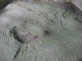
Washington State Park is a public recreation area covering 2,147 acres (869 ha) in Washington County in the central eastern part of the state of Missouri. It is located on Highway 21 about 14 miles (23 km) northeast of Potosi or 7 miles (11 km) southwest of DeSoto on the eastern edge of the Ozarks. The state park is noted for its Native American rock carvings and for its finely crafted stonework from the 1930s.
The Leo Petroglyph is a sandstone petroglyph containing 37 images of humans and other animals as well as footprints of each. The petroglyph is located near the small village of Leo, Ohio and is thought to have been created by the Fort Ancient peoples. The area in which the sandstone petroglyph was found is on the edge of an unglaciated Mississippian sandstone cliff 20–65 feet (6.1–19.8 m) high. A 20 by 16 feet slab containing the 37 carvings is protected by a wooden shelter, a Works Progress Administration project. The meanings of the drawings are unknown. On November 10, 1970, it was added to the National Register of Historic Places. The site is maintained by the Ohio History Connection.

The Red Bird River Petroglyphs, also known as the Red Bird Petroglyphs are a series of petroglyphs, or carvings, on a stone in Clay County, Kentucky. The rock originally was situated along the Red Bird River but was moved to a park in Manchester after it fell onto the roadway below in 1994.

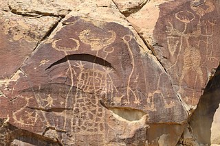
The Grapevine Canyon Petroglyphs are located in Grapevine Canyon on Spirit Mountain near Laughlin, Nevada, and are listed on the United States National Register of Historic Places. The area is also known as Christmas Tree Pass. While the petroglyphs extend through the canyon, a significant concentration lies at the entrance to the canyon which is at an elevation of 2,395 feet (730 m). The area features over 700 petroglyphs and many rock shelters.
Bell Coulee Shelter is a prehistoric rock shelter for ancient people, located in Mindoro, Wisconsin, in La Crosse County, Wisconsin.
Legend Rock Petroglyph Site is located in Hot Springs County, Wyoming, 20 miles northwest of Hot Springs State Park. Legend Rock is a petroglyph site which features hundreds of individual petroglyphs spread across the face of the rock. Although a handful of the rock's etchings have variously been eroded and defaced, a wide majority have been preserved for public viewing. The nearly 300 individual petroglyphs feature some of the oldest and best examples of Dinwoody rock art in the world. The origins of the petroglyphs are still subject to debate. The site was listed on the National Register of Historic Places on July 5, 1973 and it is preserved by the state of Wyoming as a state historic site.

Cañon Pintado, meaning painted canyon, is an archaeological site of Native American rock art located in the East Four Mile Draw, 10.5 miles (16.9 km) south of Rangely in Rio Blanco County, Colorado. Led by Ute guides, the Domínguez–Escalante expedition, Spanish missionaries in search of a route to California in 1776, passed through this region as they moved north and then west into Utah. The first Europeans to the area, they named it Cañon Pintado, meaning "painted canyon".

Judaculla Rock is a curvilinear-shaped outcrop of soapstone known for its ancient carvings and petroglyphs. The archaeological site is located on a 0.85-acre rectangular-shaped property, now owned by Jackson County. It is approximately 60 meters east of Caney Fork Creek, a major branch of the northwestward-trending Tuckasegee River in the mountains of Western North Carolina.
The Cedar Breaks Archeological District, in Cimarron County, Oklahoma near Felt, is a 160-acre (65 ha) archeological site that was listed on the U.S. National Register of Historic Places in 1978. It includes three contributing sites denoted Ci-193, Ci-194 and Ci-195; it includes rock art and at least one camp site area. It was listed on the National Register for its potential to yield information in the future.

Grimes Point, in Churchill County, Nevada near Fallon, is a 720-acre (290 ha) archeological site that was listed on the U.S. National Register of Historic Places in 1972. It was listed for its potential to yield future information.

The Piney Creek Site is a prehistoric rock art site located on the north side of Piney Creek in Piney Creek Ravine State Natural Area in Randolph County, Illinois. The site consists of a sandstone outcropping with over 150 petroglyph and pictograph designs, the most at a single known site in Illinois. The designs are divided into four distinct groups; three of these are on the center and ends of the rock shelter's wall, while the fourth is on a joint block of sandstone within the shelter. Most of the designs were created during the Late Woodland and Mississippian periods, which spanned from 450 to 1550 A.D.; a number of the figures were added after 1550. A 1 metre tall spear-holding anthropomorph in the western group is the largest individual petroglyph in Illinois. In addition to anthropomorphs, other common designs at the site include zoomorphs, quadrupeds which probably represent deer, and symbols; the quadrupeds and anthropomorphs are frequently depicted in motion. The rock shelter was likely used as a religious site by prehistoric inhabitants, and several of the designs appear to have mystical or spiritual significance; for instance, the winged anthropomorphs likely represent shamans.
The Piney Creek West Site is a prehistoric rock art site located north of Piney Creek in Piney Creek Ravine State Natural Area in Randolph County, Illinois. The site consists of four petroglyphs painted on the inside of a rock shelter and a pictograph painted on the outside. The interior petroglyphs include an abstract shape, two curved lines, and a serpentine line with a pit at one end; two of the petroglyphs are filled in with ochre pigment, representing the only intact example of this painting technique in Illinois. The pictograph, which has deteriorated badly, depicts a human left hand; nearby flecks of paint from an unrecognizably faded figure likely indicate the site of the right hand. The paintings were likely added during the Late Woodland period, which lasted from 450 to 900 A.D. The serpentine figure inside the shelter suggests that the site had spiritual significance, as it resembles other prehistoric rock art depicting shamanic trance states.

The Tegtmeyer Site is a prehistoric rock art site located north of Piney Creek in Piney Creek Ravine State Natural Area in Randolph County, Illinois. The site consists of two petroglyphs painted on a sandstone rock shelter. One petroglyph depicts a winged anthropomorph in flight, while the other depicts a winged zoomorph which may also be flying. Based on their similarity to other sites from the period, the petroglyphs at the site most likely date from the Mississippian period. The petroglyphs resemble some of the figures painted at the nearby Piney Creek Site; given that the Tegtmeyer Site was unsuitable for inhabitation, it was most likely used for additional paintings which could not fit at the Piney Creek Site.
The Goff Petroglyph Site is a rock art site in Independence County, Arkansas, in the general vicinity of Salado. The site has been known since the 19th century, and was first described by amateurs in 1937, but was not formally examined by archaeologists until 1979. The petroglyph panels depict a number of things, including animal tracks, the sun, and spirals, circles, and subdivided squares, and are estimated to date to about 1500 CE.
The Wyatt Petroglyphs are rock art located in Independence County, Arkansas, in the general vicinity of the city of Desha. The petroglyphs are of a type commonly found in eastern Missouri and southern Illinois, and are believed to date to about 1500 CE. Depictions include a thunderbird, bird tracks, arrows, human figures, and crescents and sun rays, all typical of other known regional petroglyph sites. Their relationship to area Native American archaeological sites is not well understood.

Petit Jean State Park is the oldest state park in Arkansas. It is located in the central northern part of the state, in western Conway County, atop Petit Jean Mountain, a ridge between the Ozark and Ouachita Mountains. One of the features the park is noted for is prehistoric rock art, some of which is accessible to park visitors via its hiking trails. A total of twelve such sites have been listed on the National Register of Historic Places for their importance. Most of the rock art has been dated to about 1500 CE, and is not obviously associated with habitation sites or other sites bearing evidence of other Native American activities.
The Edgemont Shelter, also designated by the Smithsonian trinomial 3VB6, is a prehistoric rock art site in Van Buren County, Arkansas. Located on a bluff overlooking Greers Ferry Lake, it consists of a panel extensively painted with petroglyphs. The site has been dated to about 1500.

The Crow Mountain Petroglyph is a small petroglyph rock art panel in Pope County, Arkansas. The panel includes a sun motif and an arrow, both of which have been pecked into the rock. Although its provenance and age are unknown, it is similar in style to other examples of rock art in the United States. The arrow was observed on December 21, 1978 to point at the location of that day's sunset, so its use as a prehistoric solstice marker cannot be ruled out.
The King's Canyon Petroglyphs are a prehistoric rock art site near Clarksville, Arkansas. The site includes a panel petroglyphs, which include depictions of a sunburst motif and what look like turkey tracks. The latter is a particularly uncommon subject for rock art in this area.
References
- 1 2 "National Register Information System". National Register of Historic Places . National Park Service. July 9, 2010.
- ↑ "Summary description of High Rock Petroglyph Shelter". Arkansas Preservation. Archived from the original on April 6, 2015. Retrieved April 5, 2015.
| Topics | |
|---|---|
| Lists by state |
|
| Lists by insular areas | |
| Lists by associated state | |
| Other areas | |
| Related | |
| | This article about a property in Crawford County, Arkansas on the National Register of Historic Places is a stub. You can help Wikipedia by expanding it. |