Historic Blenheim

Last updated
Historic Blenheim
Blenheim 003.jpg
Blenheim (Willcoxon Farm)
Fairfax.svg
Red pog.svg
USA Virginia Northern location map.svg
Red pog.svg
USA Virginia location map.svg
Red pog.svg
Usa edcp location map.svg
Red pog.svg
Location3610 Old Lee Hwy
Fairfax, Virginia
Coordinates 38°51′18.94″N77°17′34.06″W / 38.8552611°N 77.2927944°W / 38.8552611; -77.2927944
Builtc. 1859
NRHP reference No. 01000152
VLR No.151-5003
Designated VLRDecember 6, 2000 [1]

Historic Blenheim is a c. 1859 brick farm house designed in the Greek Revival style and located in City of Fairfax, Virginia. During the American Civil War, Union soldiers were often encamped on the grounds surrounding the house and utilized it as part of a reserve hospital system. As a result, more than 115 of these soldiers inscribed words and pictures on the first and second floor walls, as well as the attic of the house. Blenheim was added to the National Register of Historic Places in 2001.

Contents

Early history

The original owner of the land on which the Blenheim estate is currently located was Captain Rezin Samuel Willcoxon, a veteran of the War of 1812 who, in the early nineteenth century, began to accumulate much land in what is present-day Fairfax, Virginia. At one point, Willcoxon owned over one-thousand acres of land in the area. Rezin married his first wife, Elizabeth DeNeale, in 1805. The couple would have ten children. Elizabeth died in 1845, but in 1851 Willcoxon remarried. His new bride was Fanny Halley Bell. [2]

During the year 1850, according to the U.S. Agricultural Census, Rezin Willcoxon was farming approximately 400 acres of the land he owned. His livestock was estimated to be worth $899, and his farm produced wheat, Indian corn, and Irish potatoes. In April 1854, Rezin's son, Albert T. purchased a large tract of land from his father. It is assumed at this point he had taken over operation of the family farm and had established residency at the farmhouse on the property. According to the Alexandria Gazette and Virginia Advertiser, fire destroyed the farmhouse early in 1855, and evidence suggests the house which stands on the property today was built to replace it. Since the brick bonding for each of the exterior walls is not consistent with the foundation, the new house may have been built on the foundation of the previous house. [2]

When Rezin died in 1855, his property was split among some of his children, but Albert remained in possession of the Willcoxon house and much of the remaining property. On April 20, 1858, Albert married Mary Hunter Eskridge and the couple continued to run the farm, with the help of at least six slaves. Little information is known about them, however. There is a chance that Albert and Mary inherited some of their slaves or received them as wedding gifts from their parents. The names of only three of the slaves are known for certain. Records show that Albert purchased a young man named Charles in 1856. In 1859 he purchased, from his sister, another man named Hanson, who had been in the Willcoxon family since 1806. There are also records of a woman, Maria, whom Albert sold to his sister-in-law, Isabelle K. Eskridge, in 1859. There were most likely two slave quarters on the property. [3]

The Civil War years

Albert and his wife were supporters of secession and supported the Confederate cause by selling Confederate soldiers large quantities of supplies. Some of the items Albert sold during the early war years were beef, hay, blacksmith supplies, horses and pork. By October 1862, however, Fairfax was controlled mainly by the Union army, which ravaged the area and depleted much of the landscape. The Willcoxon estate suffered from this. At some point in 1862, Albert, his wife, and their two children left the area. Since Mary's family was from Leesburg, in Loudoun County, VA, it is possible that the couple and their two children stayed there until the end of the war. [2]

Military significance of Fairfax and Blenheim

Due to its proximity to the nation's capital, Fairfax was important to the defense of Washington, D.C. Since Blenheim is located at the edge of Fairfax, the Willcoxon family's land was in the middle of wartime activity in the town. Not long after the start of the war, a Confederate force of around 300 men guarded the town. On June 1, 1861, a Union cavalry unit advanced on the town and attacked the Confederate force. Despite the fact that the Confederates were poorly equipped and were not warned of the Union advance, they held off the Northern troops and retained possession of the town. During the skirmish, however, the war saw its first Confederate officer killed. [2]

On July 17, 1861, a Union officer reported that Fairfax was now occupied by the Northern Army. By the end of that year, the Army of the Potomac was using the courthouse in Fairfax as army headquarters. Some evidence suggests that Blenheim may have once served as headquarters as well. Between 1861 and 1863 control of the city changed hands numerous times, but by March 1863, it was solidified as a Union stronghold. [2]

Union soldiers and Blenheim

Example of writing and artwork in the attic of Historic Blenheim Blenheim inscriptions.jpg
Example of writing and artwork in the attic of Historic Blenheim

Because of Blenheim's location within Fairfax, and its abandonment by its owners, the house eventually became fully occupied by Union soldiers. At various points, the house was most likely used as a hospital for Union soldiers. Union troops not only found refuge in the house, but left their physical mark there as well. Soldiers who stayed at the house left writings on the walls of the first, second, and attic levels. These walls contain over one hundred names, units, dates, poems, and artistic drawings. At least twenty-three different military regiments are represented on the walls, including the 26th Wisconsin Infantry, 83rd Pennsylvania Infantry, 58th New York Infantry, 136th New York Infantry, and the 1st Michigan Cavalry. The earliest writings in the house date to March 1862. [2]

Some of the men who wrote on the walls of Blenheim would later perish at places like 2nd Manassas, Chancellorsville, and Gettysburg. Some of the other inscriptions may have been from men who were wounded during skirmishes right in Fairfax, or who contracted diseases at local encampments. [4]

Research on the Blenheim soldiers began in 1997. Names on the walls were deciphered and checked in basic public resources from the Civil War era and later. Once the name and regiment of a soldier were confirmed, files were pulled from the National Archives and Records Administration. Various historical societies, genealogical groups, state resources, and the internet were also used to reveal the stories of the men of Blenheim. [5]

Postbellum Blenheim

When Albert died in 1889, all his land, which included Willcoxon Place and approximately 367 acres, was split between his children, Harry and Bessie. Harry ran the farm through the start of the twentieth century, and under his leadership the farm prospered. His farm became especially known for its dairy production, and some credited him with providing the best milk in the area. During the year 1903, the earliest use of the name ‘Blenheim’ for Willcoxon Place was recorded in the family obituary for Albert's wife, Mary Eskridge Willcoxon. However, the property continued to be called ‘Willcoxon Place’ throughout the twentieth century. [2]

The 1930s found the farm being run by a tenant farmer. In 1939, Harry willed Blenheim to his niece Marguerite (Daisy), and moved to his other farm in Centreville, VA, where he died in 1942. Farm operations at Blenheim continued through the 1950s. An insurance survey of 1950 listed the farm as having two tenant houses, the main house, a privy, chicken house, pump house, machinery shed and workshop, dairy barn and house, calf house, granary, corn crib, house barn, a second machinery and hay shop, a cow shed, and a hog shed. By 1953, the Willcoxon heirs had begun to sell off large parcels of the farm for development, and soon the original landholdings around Blenheim were reduced to twelve acres. Before her death in 1959 Marguerite (Daisy) had given the estate to her daughter, Barbara Duras, who moved into the house with her husband, William in 1962. Barbara died in 1987, followed by William in 1997. The City of Fairfax purchased the site in January 1999. The family cemetery, located next to the house, includes four generations of the Willcoxon family. [4] [6]

Today

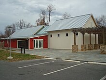
The Civil War Interpretive Center at Historic Blenheim Civil War Interpretive Center at Historic Blenheim.jpg
The Civil War Interpretive Center at Historic Blenheim

The Willcoxon family and their descendants never covered the inscriptions in the attic of their home. The attic space was probably used mostly for storage after the war. Many layers of wallpaper were added to the first and second levels of the home through the twentieth century, but the drawings on the walls were never destroyed. [5] Today, the wallpaper on the two main floors has been removed and the inscriptions are visible throughout.

In 2001 Historic Blenheim was added to the National Register of Historic Places. Adjacent to the house is the Civil War Interpretive Center, opened in 2008. The Center's mission is to enhance the educational experience of the site for visitors. A gallery inside the Interpretive Center contains displays which places the Union soldiers who stayed at Blenheim within the larger framework of the American Civil War. Since the second floor and the attic are not accessible by the public, the Center also hosts an exact replica of two-thirds of Blenheim's attic with life-sized images of the inscriptions. Additional features include an assembly room for school groups, tour groups, lectures and special programs, along with temporary exhibits which are displayed on the walls. [6]

Related Research Articles

<span class="mw-page-title-main">Ox Hill Battlefield Park</span>

Ox Hill Battlefield Park is a site in Fairfax, Virginia, where the Battle of Ox Hill was fought during the American Civil War. It was the only major battle of the war fought in Fairfax County. The battlefield is now a public park adjacent to suburban developments and the Fairfax Towne Center shopping center, and is maintained by the Fairfax County Park Authority.

<span class="mw-page-title-main">Sloan–Parker House</span> Historic house in West Virginia, United States

The Sloan–Parker House, also known as the Stone House, Parker Family Residence, or Richard Sloan House, is a late-18th-century stone residence near Junction, Hampshire County, in the U.S. state of West Virginia. It was built on land vacated by the Shawnee after the Native American nation had been violently forced to move west to Kansas following their defeat at the Battle of Point Pleasant in 1774. The building was added to the National Register of Historic Places on June 5, 1975, becoming Hampshire County's first property to be listed on the register. The Sloan–Parker House has been in the Parker family since 1854. The house and its adjacent farm are located along the Northwestern Turnpike in the rural Mill Creek valley.

<span class="mw-page-title-main">Manassas National Battlefield Park</span> Battlefield in Virginia, USA

Manassas National Battlefield Park is a unit of the National Park Service located in Prince William County, Virginia, north of Manassas that preserves the site of two major American Civil War battles: the First Battle of Bull Run, also called the Battle of First Manassas, and the Second Battle of Bull Run or Battle of Second Manassas. It was also where Confederate General Thomas J. Jackson acquired his nickname "Stonewall". The park was established in 1936 and listed on the National Register of Historic Places on October 15, 1966.

<span class="mw-page-title-main">Winchester National Cemetery</span> Historic veterans cemetery in Winchester County, Virginia

Winchester National Cemetery is a United States National Cemetery located in the city of Winchester in Frederick County, Virginia. Administered by the United States Department of Veterans Affairs, it encompasses 4.9 acres (2.0 ha), and as of the end of 2005, it had 5,561 interments. It is closed to new interments.

<span class="mw-page-title-main">Woodlawn (Alexandria, Virginia)</span> Historic house in Virginia, United States

Woodlawn is a historic house located in Fairfax County, Virginia. Originally a part of Mount Vernon, George Washington's historic plantation estate, it was subdivided in the 19th century by abolitionists to demonstrate the viability of a free labor system. The address is now 9000 Richmond Highway, Alexandria, Virginia, but due to expansion of Fort Belvoir and reconstruction of historic Route 1, access is via Woodlawn Road slightly south of Jeff Todd Way/State Route 235. The house is a designated National Historic Landmark, primarily for its association with the Washington family, but also for the role it played in the historic preservation movement. It is now a museum property owned and managed by the National Trust for Historic Preservation.

<span class="mw-page-title-main">Leesylvania State Park</span> State park in Prince William County, Virginia

Leesylvania State Park is located in the southeastern part of Prince William County, Virginia. The land was donated in 1978 by businessman Daniel K. Ludwig, and the park was dedicated in 1985 and opened full-time in 1992.
<span class="mw-page-title-main">Merrybrook</span> Historic house in Virginia, United States

Merrybrook is the only known remaining home of American Civil War Confederate spy Laura Ratcliffe. The house is located south of Herndon, Virginia, in Fairfax County, Virginia. She lived here from the earliest days of the Civil War until her death in 1923. The interior, out-buildings and grounds still retain the atmosphere of earlier times.
<span class="mw-page-title-main">Ball's Bluff Battlefield and National Cemetery</span> Historic site in Loudoun County, Virginia, US

Ball's Bluff Battlefield Regional Park and National Cemetery is a battlefield area and a United States National Cemetery, located 2 miles (3.2 km) northeast of Leesburg, Virginia. The cemetery is the third smallest national cemetery in the United States. Fifty-four Union Army dead from the Battle of Ball's Bluff are interred in 25 graves in the half-acre plot; the identity of all of the interred except for one, James Allen of the 15th Massachusetts, are unknown. Monuments to fallen Confederate Sergeant Clinton Hatcher and Union brigade commander Edward Dickinson Baker are located next to the cemetery, though neither is buried there. While the stone wall-enclosed cemetery itself is managed through the Culpeper National Cemetery and owned by the Department of Veterans Affairs, the balance of the 223-acre (0.90 km2) park is managed through the Northern Virginia Regional Park Authority.

<span class="mw-page-title-main">Washington Bottom Farm</span> Historic house in West Virginia, United States

Ridgedale is a 19th-century Greek Revival plantation house and farm on a plateau overlooking the South Branch Potomac River north of Romney, West Virginia, United States. The populated area adjacent to Washington Bottom Farm is known as Ridgedale. The farm is connected to West Virginia Route 28 via Washington Bottom Road.

<span class="mw-page-title-main">Clover Hill Tavern</span> Historic commercial building in Virginia, United States

The Clover Hill Tavern with its guest house and slave quarters are structures within the Appomattox Court House National Historical Park in Appomattox County, Virginia. They were registered in the National Park Service's database of Official Structures on October 15, 1966.

<span class="mw-page-title-main">Huntley (plantation)</span> Historic house in Virginia, United States

Huntley, also known as Historic Huntley or Huntley Hall is an early 19th-century Federal-style villa and farm in the Hybla Valley area of Fairfax County, Virginia. The house sits on a hill overlooking Huntley Meadows Park to the south. The estate is best known as the country residence of Thomson Francis Mason, grandson of George Mason of nearby Gunston Hall. It is listed on the National Register of Historic Places (NRHP), the Virginia Landmarks Register (VLR), and the Fairfax County Inventory of Historic Sites.

Okeley Manor was an early 19th-century plantation in Fairfax County, Virginia, United States. Okeley, the residence of prominent Alexandria physician Richard Chichester Mason (1793–1869), was one of the principal Mason family estates in Northern Virginia. Mason's plantation house was used as a hospital during the American Civil War and burned to prevent the spread of smallpox.

<span class="mw-page-title-main">Wappocomo (Romney, West Virginia)</span> Georgian mansion in Romney, US

Wappocomo is a late 18th-century Georgian mansion and farm overlooking the South Branch Potomac River north of Romney, Hampshire County, West Virginia, USA. It is located along Cumberland Road and the South Branch Valley Railroad.

Hope Park was an 18th and 19th-century plantation in Fairfax County, Virginia, where Dr. David Stuart (1753–1814), an old friend of and correspondent with George Washington lived with his wife, Eleanor Calvert Custis (1758–1811), and family. It was approximately 5 miles (8.0 km) southwest of Fairfax Court House.

<span class="mw-page-title-main">Francis Land House</span> Historic house in Virginia, United States

The Francis Land House, or Rose Hall, is a historic brick house in located within the Rose Hall District near Princess Anne Plaza in Virginia Beach, Virginia. It was the plantation home of the prominent Land family, a founding family of Princess Anne County, Virginia.

<span class="mw-page-title-main">The Stone House, Manassas National Battlefield Park</span> United States historic place

The Stone House, Manassas National Battlefield Park, is a two-story stone structure in Prince William County, Virginia. It was built as a stop on the Fauquier and Alexandria Turnpike in 1848. During the American Civil War, The Stone House served as a hospital during the First and Second Battles of Manassas.

<span class="mw-page-title-main">Historic Fairfax County Courthouse</span> Historic courthouse in Virginia, United States

The Historic Fairfax County Courthouse is one of the oldest buildings in Fairfax, Virginia. It was constructed in 1799 to serve as the seat of government in Fairfax County. During the American Civil War, the first Confederate officer casualty of the war took place on the courthouse grounds and the building was occupied by both sides in the conflict. Today, the original courthouse building is part of the larger courthouse site that serves the local government of Fairfax County.
<span class="mw-page-title-main">John Quincy Marr</span> Confederate States Army first combat casualty (1825–1861)

John Quincy Marr was a Virginia militia company captain and the first Confederate soldier killed by a Union soldier in combat during the American Civil War. Marr was killed at the Battle of Fairfax Court House in Fairfax, Virginia, on June 1, 1861. Previously one of Fauquier County's two delegates to the Virginia Secession Convention of 1861, Marr initially opposed his state's secession from the Union but ultimately supported secession, as did voters shortly before his fatal skirmish.

<span class="mw-page-title-main">History of Alexandria, Virginia</span> Alexandria in American History

The history of Alexandria, Virginia, begins with the first European settlement in 1695. Over the next century, the town became a significant port. In 1801, much of Alexandria was swept into the new District of Columbia; it was damaged along with much of the rest of the capital during the War of 1812. In 1846, Alexandria was returned to Virginia, along with the rest of the District's territory on the western side of the Potomac River. After Virginia seceded in 1861, Alexandria was swiftly captured by Union forces and held for the remainder of the American Civil War. In the late 20th century, Alexandria became a key part of the rapidly growing Northern Virginia region.
<span class="mw-page-title-main">Ellanor C. Lawrence Park</span> Park in Chantilly, Virginia, United States

Ellanor C. Lawrence Park is located in Chantilly, Virginia, just north of Centreville, on Route 28. The park preserves the cultural and natural resources of western Fairfax County and has a long and complex history lasting 8,000 years. The land was originally inhabited by Native Americans, but as Europeans settled in Virginia, the land was shaped by only three families: the Browns, Machens and Lawrences. Through these periods, the land was used as a tenant farm, family homestead, and country estate until it was deeded to Fairfax County Park Authority as a 640-acre nature park in 1971.

References

  1. "Virginia Landmarks Register". Virginia Department of Historic Resources. Retrieved 19 March 2013.
  2. 1 2 3 4 5 6 7 United States Department of the Interior: National Park Service. Blenheim Nomination. National Register of Historic Places.
  3. Foster, Sarah and Andrea Loewenwarter (May 2000). An Historical Overview of Blenheim. City of Fairfax, VA.{{cite book}}: CS1 maint: location missing publisher (link)
  4. 1 2 Loewenwarter, Andrea J. (May 1999). A Brief History of Blenheim: A Civil War Historic Site in the City of Fairfax, VA.
  5. 1 2 Historic Blenheim Civil War Interpretive Center. Blenheim Soldiers Attic Guide.
  6. 1 2 Historic Blenheim and Civil War Interpretive Center. A Diary on the Walls.