Newspaper Rock State Historic Monument is a Utah state monument featuring a rock panel carved with one of the largest known collections of petroglyphs. It is located in San Juan County, along Utah State Route 211, 28 miles (45 km) northwest of Monticello and 53 miles (85 km) south of Moab.

Mesa Verde National Park is an American national park and UNESCO World Heritage Site located in Montezuma County, Colorado. The park protects some of the best-preserved Ancestral Puebloan archaeological sites in the United States.
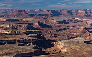
Canyonlands National Park is an American national park located in southeastern Utah near the town of Moab. The park preserves a colorful landscape eroded into numerous canyons, mesas, and buttes by the Colorado River, the Green River, and their respective tributaries. Legislation creating the park was signed into law by President Lyndon B. Johnson on September 12, 1964.

Bandelier National Monument is a 33,677-acre (13,629 ha) United States National Monument near Los Alamos in Sandoval and Los Alamos counties, New Mexico. The monument preserves the homes and territory of the Ancestral Puebloans of a later era in the Southwest. Most of the pueblo structures date to two eras, dating between 1150 and 1600 AD.

The Fremont culture or Fremont people is a pre-Columbian archaeological culture which received its name from the Fremont River in the U.S. state of Utah, where the culture's sites were discovered by local indigenous peoples like the Navajo and Ute. In Navajo culture, the pictographs are credited to people who lived before the flood. The Fremont River itself is named for John Charles Frémont, an American explorer. It inhabited sites in what is now Utah and parts of Nevada, Idaho, Wyoming and Colorado from AD 1 to 1301. It was adjacent to, roughly contemporaneous with, but distinctly different from the Ancestral Pueblo peoples located to their south.

Hovenweep National Monument is located on land in southwestern Colorado and southeastern Utah, between Cortez, Colorado and Blanding, Utah on the Cajon Mesa of the Great Sage Plain. Shallow tributaries run through the wide and deep canyons into the San Juan River.

Horseshoe Bend is a horseshoe-shaped incised meander of the Colorado River located near the town of Page, Arizona, United States. It is also referred to as the "east rim of the Grand Canyon."

Thompson Springs, also officially known for a time as just Thompson, is a small census-designated place in central Grand County, Utah, United States. The population was 39 at the 2010 census. The town is just north of the east–west highway route shared by Interstate 70, U.S. Route 6 and U.S. Route 50, between Crescent Junction and Cisco. Moab, the county seat, is 37 miles (60 km) to the south. Thompson Springs is located in high desert country at an elevation of 5,246 feet (1,599 m), with the Book Cliffs just to the north. The town's ZIP code is 84540. The mystery "The Silver Spur Cafe" by Chinle Miller is partially set in Thompson Springs.

The Canyon Lands Section of the Colorado Plateau is a physiographic section of the larger Colorado Plateaus province, which in turn is part of the larger Intermontane Plateaus physiographic division in the Western United States
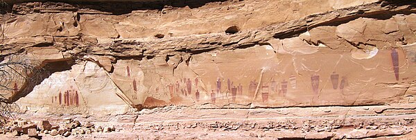
Barrier Canyon Style (BCS) describes a distinctive style of rock art which appears mostly in Utah, with the largest concentration of sites in and around the San Rafael Swell and Canyonlands National Park, but the full range extends into much of the state and western Colorado. The term was first applied by Polly Schaafsma to describe a handful of similar sites known at the time, including several along Barrier Creek in Horseshoe Canyon. Barrier Canyon Style rock art panels are mostly pictographs (painted) but there are also several petroglyphs (pecked) in the style. These panels are believed to have been created during the archaic period and are estimated to be somewhere in the range of 1500 to 4000 years old, possibly older -- clay figurines of a similar style found in Cowboy Cave have been dated to over 7000 years old.

The Prehistoric Museum, USU-Eastern, formerly known as the College of Eastern Utah Prehistoric Museum, is a museum accredited by the American Alliance of Museums located in Price, Utah. The museum seeks to promote public understanding of prehistory through interpretive exhibits, educational programs, collections, and research. The museum is located near many paleontological and archaeological sites in a region known as Castle Country, notably in the San Rafael Swell and nearby canyons throughout the Book Cliffs area such as Nine Mile Canyon and Range Creek Canyon.

The Buckhorn Draw Pictograph Panel is an example of rock art, located in Buckhorn Draw in the San Rafael Swell in central Utah, approximately four miles north of the San Rafael campground and bridge.

Zion National Park is an American national park located in southwestern Utah near the town of Springdale. Located at the junction of the Colorado Plateau, Great Basin, and Mojave Desert regions, the park has a unique geography and a variety of life zones that allow for unusual plant and animal diversity. Numerous plant species as well as 289 species of birds, 75 mammals, and 32 reptiles inhabit the park's four life zones: desert, riparian, woodland, and coniferous forest. Zion National Park includes mountains, canyons, buttes, mesas, monoliths, rivers, slot canyons, and natural arches. The lowest point in the park is 3,666 ft (1,117 m) at Coalpits Wash and the highest peak is 8,726 ft (2,660 m) at Horse Ranch Mountain. A prominent feature of the 229-square-mile (590 km2) park is Zion Canyon, which is 15 miles (24 km) long and up to 2,640 ft (800 m) deep. The canyon walls are reddish and tan-colored Navajo Sandstone eroded by the North Fork of the Virgin River.

Painting in the Americas before European colonization is the Precolumbian painting traditions of the Americas. Painting was a relatively widespread, popular and diverse means of communication and expression for both religious and utilitarian purpose throughout the regions of the Western Hemisphere. During the period before and after European exploration and settlement of the Americas; including North America, Central America, South America and the islands of the Caribbean, the Bahamas, the West Indies, the Antilles, the Lesser Antilles and other island groups, indigenous native cultures produced a wide variety of visual arts, including painting on textiles, hides, rock and cave surfaces, bodies especially faces, ceramics, architectural features including interior murals, wood panels, and other available surfaces. Many of the perishable surfaces, such as woven textiles, typically have not been preserved, but Precolumbian painting on ceramics, walls, and rocks have survived more frequently.

Cataract Canyon is a 46-mile-long (74 km) canyon of the Colorado River located within Canyonlands National Park and Glen Canyon National Recreation Area in southern Utah. It begins at Colorado's confluence with the Green River, and its downstream terminus is the confluence with the Dirty Devil River. The lower half of the canyon is submerged beneath Lake Powell when the lake is at its normal high water elevation of 3,700 feet (1,100 m).
The Courthouse Wash Pictographs are a series of large pictographs created over a long period of time, located on a sheltered sandstone wall at the mouth of Courthouse Wash, Arches National Park in Grand County, Utah, United States, just north of Moab, that is listed on the National Register of Historic Places (NRHP).

The Ancestral Puebloans, also known as the Anasazi, were an ancient Native American culture that spanned the present-day Four Corners region of the United States, comprising southeastern Utah, northeastern Arizona, northwestern New Mexico, and southwestern Colorado. They are believed to have developed, at least in part, from the Oshara tradition, which developed from the Picosa culture. The people and their archaeological culture are often referred to as Anasazi, meaning "ancient enemies", as they were called by Navajo. Contemporary Puebloans object to the use of this term, with some viewing it as derogatory.

Aztec Butte is a sandstone summit, elevation 6,312 feet, located in the Island in the Sky District of Canyonlands National Park, in San Juan County, Utah. Aztec Butte is composed of white cross-bedded Navajo Sandstone, which is the remains of wind-borne sand dunes deposited approximately 170 million years ago during the Jurassic Period. It resembles the Pyramid of the Sun in Mexico, which was built by the Aztecs.

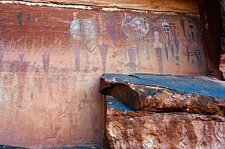
The Thompson Wash Rock Art District, known by the Bureau of Land Management as the Sego Canyon Rock Art Interpretive Site, is a rock art site in Grand County, Utah, north of the town of Thompson Springs. It contains art from three different cultures: the Fremont, the Ute, and the Barrier Canyon Style.

Hickman Bridge a large natural bridge located near the Fremont River in Capitol Reef National Park. The bridge has a span of 133 feet and a height of 125 feet, and is one of the largest rock spans in the park.