
Coconino County is a county in the North-Central part of the U.S. state of Arizona. Its population was 145,101 at the 2020 census. The county seat is Flagstaff. The county takes its name from Cohonino, a name applied to the Havasupai people. It is the second-largest county by area in the contiguous United States, behind San Bernardino County, California. It has 18,661 sq mi (48,300 km2), or 16.4% of Arizona's total area, and is larger than the nine smallest states in the U.S.

State Route 89A is an 83.85-mile (134.94 km) state highway that runs from Prescott north to Flagstaff in the U.S. state of Arizona. The highway begins at SR 89 in Yavapai County and heads northward from Prescott Valley, entering Jerome. From Jerome, the route then heads to Cottonwood and Clarkdale. The road then continues out to Sedona. The highway is notable for its scenic value as it winds over and through Mingus Mountain as well as passing through Sedona and the Oak Creek Canyon. The route then enters Coconino County soon after leaving Sedona. The highway proceeds to Flagstaff, where it crosses Interstate 17 (I-17) and I-40. The highway ends at I-40 Business in Flagstaff. What is now SR 89A became a state highway in the late 1920s as SR 79. The highway was extended and improved several times through 1938. SR 79 was renumbered to U.S. Route 89A in 1941 and then to SR 89A in the early 1990s.
The Paria Canyon-Vermilion Cliffs Wilderness is a 112,500 acres (455 km2) wilderness area located in northern Arizona and southern Utah, United States, within the arid Colorado Plateau region. The wilderness is composed of broad plateaus, tall escarpments, and deep canyons.

Wrather Arch is a cave type natural arch in the Paria Canyon-Vermilion Cliffs Wilderness, in Coconino County, northern Arizona. The sandstone arch is located in the eponymous Wrather Canyon, a short side canyon of Paria Canyon. The Paria River is a tributary of the Colorado River, at its confluence down−canyon at Lee's Ferry. Wrather Arch was first spotted by a local pilot from Page, Arizona, Royce K Knight, as he flew over a remote gorge west of Glen Canyon. Reaching the arch by helicopter in 1963, Knight and National Geographic staff man Walter M Edwards calculated its height as 165 feet and about 250 feet across. A news bulletin from National Geographic dated February 4, 1966 states, "Tall as a 15 story building, Wrather Arch ... The Taj Mahal would fit comfortably into the arch..."
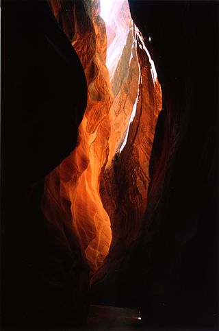
Buckskin Gulch is a gulch and canyon located in southern Kane County, Utah, near the Arizona border in the Paria Canyon-Vermilion Cliffs Wilderness. With a length of over 16 miles (26 km), it is one of the main tributaries of the Paria River, a tributary of the Colorado River.

U.S. Route 89A is a 91.74-mile (147.64 km) north–south auxiliary U.S. highway in southwestern Kane County, Utah and northeastern Coconino County, Arizona in the southwestern United States. The highway is an old routing of U.S. Route 89 from Bitter Springs, Arizona to Kanab, Utah. The state of Arizona has designated this highway the Fredonia-Vermilion Cliffs Scenic Road. The highway is used to access the North Rim of Grand Canyon National Park and is known for the Navajo Bridge. Until 2008, the Utah portion was signed State Route 11. The route provides the only direct road connection between the Arizona Strip and the rest of Arizona.

The Wave is a sandstone rock formation located in Arizona, US, near its northern border with Utah. The formation is situated on the slopes of the Coyote Buttes in the Paria Canyon-Vermilion Cliffs Wilderness of the Colorado Plateau. The area is administered by the Bureau of Land Management (BLM) at the Grand Staircase–Escalante National Monument visitor center in Kanab, Utah.

Wire Pass Trailhead is a recreation access point in Kane County, Utah that features several trails leading to natural points of interest.

The Arizona Strip is the part of Arizona lying north of the Colorado River. Despite being larger in area than several U.S. states, the entire region has a population of fewer than 10,000 people. Consisting of northeastern Mohave County and northwestern Coconino County, the largest settlements in the Strip are Colorado City, Fredonia, and Beaver Dam, with smaller communities of Scenic, Littlefield and Desert Springs. The Kaibab Indian Reservation lies within the region. Lying along the North Rim of the Grand Canyon creates physical barriers to the rest of Arizona. Only three major roads traverse the region: I-15 crosses the northwestern corner, while Arizona State Route 389 and U.S. Route 89A cross the northeastern part of the strip, and US 89A crosses the Colorado River via the Navajo Bridge, providing the only direct road connection between the strip and the rest of the state. The nearest metropolitan area is the St. George, Utah metro area, to which the region is more connected than to the rest of Arizona.

The Vermilion Cliffs are the second "step" up in the five-step Grand Staircase of the Colorado Plateau, in northern Arizona and southern Utah in the southwestern United States. They extend west from near Page, Arizona, for a considerable distance, in both Arizona and Utah.

Vermilion Cliffs National Monument is located in northern Coconino County, Arizona, United States, immediately south of the Utah state line. This national monument, 293,689 acres (118,852 ha) in area, protects the Paria Plateau, Vermilion Cliffs, Coyote Buttes, and Paria Canyon. Elevations in the monument range from 3,100 feet to 6,500 feet above sea level.

Oak Creek Canyon is a river gorge located in northern Arizona between the cities of Flagstaff and Sedona. The canyon is often described as a smaller cousin of the Grand Canyon because of its scenic beauty. State Route 89A enters the canyon on its north end via a series of hairpin turns before traversing the bottom of the canyon for about 13 miles (21 km) until the highway enters the town of Sedona.

Jacob Lake is a small unincorporated community on the Kaibab Plateau in Coconino County, Arizona, United States, at the junction of U.S. Route 89A and State Route 67. Named after the Mormon explorer Jacob Hamblin, the town is known as the "Gateway to the Grand Canyon" because it is the starting point of Route 67, the only paved road leading to the North Rim of the Grand Canyon some 44 miles (71 km) to the south. The town itself consists of the Jacob Lake Inn which maintains motel rooms and cabins, a restaurant, lunch counter, gift shop, bakery, and general store; a gas station/garage; campground; and a visitors center run by the U.S. Forest Service. In the summer months, there is also a nearby center for horse rides.

U.S. Route 89 (US 89) is a U.S. Highway in the U.S. state of Arizona that begins in Flagstaff and heads north to the Utah border northwest of Page. US 89 is among the first U.S. Highways established in Arizona between November 11, 1926 and September 9, 1927. Until 1992, US 89 started at the international border in Nogales and was routed through Tucson, Phoenix and Prescott between Nogales and Flagstaff. State Route 79 and State Route 89 are both former sections of US 89.

Marble Canyon is an unincorporated community along the Colorado River in Coconino County, Arizona, United States. It is partially located within the Glen Canyon National Recreation Area and the Grand Canyon National Park.
Buckskin Mountain is a 16-mile (26 km) mountain ridge that spans from Coconino County, Arizona to Kane County, Utah in the United States, that is divided almost equally between the two counties.

Walnut Creek is a major stream in Coconino County, Arizona that is part of the Little Colorado River drainage basin. The creek flows about 34 miles (55 km) in a northeasterly direction from south of Flagstaff to near Winona.
House Rock Valley is a valley on Paria Plateau, north of the Grand Canyon, in Coconino County, Arizona, United States. The valley was named by the John Wesley Powell Expedition after a rock formation in the valley where they spent the night in 1871. It is traversed by a highway that is currently designated as U.S. Route 89A.
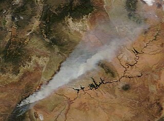
The Mangum Fire was a wildfire in Kaibab National Forest in Arizona in the United States. The fire, which started on June 8, 2020 approximately 16 miles north of the North Rim of Grand Canyon National Park, burned a total of 71,450 acres (28,915 ha). The fire threatened the community of Jacob Lake, Arizona, resulting in its evacuation. Select highways were closed, including Highway 67, which resulted in closure of the North Rim of the Grand Canyon. Additionally, areas of the Paria Canyon-Vermilion Cliffs Wilderness were inaccessible due to closures. Four buildings were destroyed, including two historic cabins. The exact cause of the fire remains under investigation, however, fire officials have confirmed it was human caused.
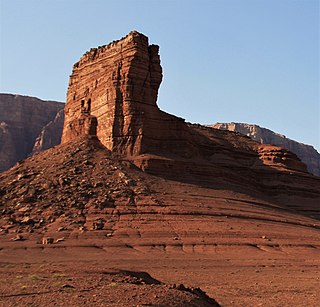
Cathedral Rock is a 3,942-foot-elevation (1,202 m) pillar located within Glen Canyon National Recreation Area, in Coconino County of northern Arizona. It is situated less than one mile northwest of Navajo Bridge, and three miles (4.8 km) southwest of Lee's Ferry and the confluence of the Paria and Colorado Rivers, where it towers over 400 feet (120 m) above the surrounding terrain as a landmark of the area. It can be seen from nearby U.S. Route 89A (US 89A) at Marble Canyon. This geographical feature's name was bestowed prior to 1900, and officially adopted in 1969 by the U.S. Board on Geographic Names.


