Hurricane Nicholas

Last updated
Map key
  Tropical depression (≤38 mph, ≤62 km/h)
  Tropical storm (39–73 mph, 63–118 km/h)
  Category 1 (74–95 mph, 119–153 km/h)
  Category 2 (96–110 mph, 154–177 km/h)
  Category 3 (111–129 mph, 178–208 km/h)
  Category 4 (130–156 mph, 209–251 km/h)
  Category 5 (≥157 mph, ≥252 km/h)
  Unknown
Storm type
Disc Plain black.svg Tropical cyclone
Solid black.svg Subtropical cyclone
ArrowUp.svg Extratropical cyclone, remnant low, tropical disturbance, or monsoon depression

On August 28, a tropical wave moved off the west coast of Africa. [1] It moved steadily westward over the next week, producing only disorganized convection before moving into and through the Caribbean Sea. At 06:00 UTC on September 9, the National Hurricane Center (NHC) began to monitor the northern portion the tropical wave over the western Caribbean Sea for potential development as it moved across northern Central America and the Yucatán Peninsula toward the Bay of Campeche. [2] By the next day, the wave began to interact with a surface trough over the southern Gulf of Mexico, producing widespread but disorganized showers and thunderstorms across the region. [3] Showers and thunderstorms associated with this system increased and become better organized on September 12, and its top sustained winds reached 40 mph (65 km/h) (tropical storm-force), as confirmed by an Air Force hurricane-hunter flight that morning. [4] As a result, advisories were initiated at 15:00 UTC on Tropical Storm Nicholas. [5]

The tropical wave that would become Nicholas shortly before forming on September 12. 2021 CIMSS 14L Fourteen visible infrared satellite loop.gif
The tropical wave that would become Nicholas shortly before forming on September 12.

After forming, the storm was found to be not very organized, as it lacked convective banding features. The center was also not well defined. [6] After satellite imagery from radar and aircraft, it was found that the center had re-formed 150 nautical miles more north than expected and the storm had gained speed. [7] The storm entered the southern part of a large area of deep convection, as signs of an eyewall structure forming were beginning to become prominent. [8] The eyewall structure then dissipated and a new center began forming north-northeast of the previous. [9] The storm then underwent a period of rapid intensification, the fifth hurricane of the season to do so, after intensifying by 35 mph (55 km/h) in a 24-hour period. [10] Consequently, at 03:00 UTC on September 14, the system was upgraded to a Category 1 hurricane. [11] Shortly thereafter, at 05:30 UTC, Nicholas made landfall about 10 mi (16 km) west-southwest of Sargent Beach, Texas, with maximum sustained winds of 75 mph (121 km/h). [10] [12] It then quickly weakened inland to tropical storm strength, as it moved to near Galveston Bay. [13] Nicholas was downgraded to tropical depression status at 00:00 UTC on September 15, [14] as it moved slowly into southern Louisiana, where residents were still recovering in the aftermath of Hurricane Ida. [15] At the time, the system consisted of a large swirl of low- to mid-level clouds and showers, with a few patches of deep convection well removed from the center, according to the NHC. [16] Early the following day, while situated near Marsh Island, along the Louisiana coast, Nicholas became post-tropical. [17] [18] Nicholas's remnant low later moved further inland, stalling over northern Louisiana, [19] [20] [21] before its low-level circulation center became ill-defined on September 18. [1] The storm's remnants persisted for another few days, before they were absorbed into an extratropical storm to the north on September 20. [1] The system's residual tropical moisture lingered over parts of the southeastern U.S. for several days. [22] [23] [24]

Preparations

Nicholas nearing the coast of Texas on September 13. Nicholas 2021-09-13 2251Z.jpg
Nicholas nearing the coast of Texas on September 13.

When Tropical Storm Nicholas formed, tropical storm warnings were issued along the coast from Barra El Mezquital and north to Port Aransas, Texas. Additionally, tropical storm watches were called from Port Aransas to High Island, Texas. As Nicholas neared landfall, tropical storm alerts were issued for the entire Texas coast. The first hurricane warning was issued from Port O'Connor to Freeport, Texas at 03:00 UTC, when the storm was upgraded to a Category 1 hurricane. [11] Flood watches were also issued in southern and central Louisiana when Nicholas slowed its forward speed to 5 miles per hour (8.0 km/h). [25] In addition to flood watches, the Weather Prediction Center issued a rare 50 percent high-risk flooding area for southwestern Louisiana. [26]

Rainfall estimate totals were 8 to 16 inches (200 to 410 mm), with some locations potentially receiving 15 inches (380 mm). Coastal Louisiana, which was battered by Hurricane Ida just weeks earlier, was estimated to receive 5 to 10 inches (130 to 250 mm). Lake Houston was lowered by one foot (30 cm). [27] Schools in southern Texas and Louisiana were suspended on September 13. [28] [29] [30] At least 330 flights originating from William P. Hobby Airport and George Bush Intercontinental Airport were cancelled. [31] In Harris County, COVID-19 testing sites were closed. [32] Late on September 13, ferry service between Galveston and the Bolivar Peninsula were suspended. Service resumed the next day. [33]

Governor of Louisiana, John Bel Edwards, declared a state of emergency and noted that areas affected by Hurricane Ida would possibly feel the effects of the tropical storm. [34] Edwards also requested a federal disaster declaration, which was approved by President Joe Biden on September 14. [32] [35] The Governor of Texas, Greg Abbott, issued a disaster declaration for 17 counties in southeastern Texas and ordered the State Operations Center to increase its readiness level. [36] The Louisiana National Guard deployed 80 high water vehicles, 23 boats and 15 aircraft across southern Louisiana. [31] On September 13, before the storm hit, singer-songwriter Harry Styles postponed his performance in Houston. [37] Dozens of barriers were constructed in Houston and readied high-water rescue vehicles. [38] The American Red Cross in the Texas Gulf Coast area prepared as Nicholas moved closer to landfall. [39]

Impact and aftermath

Losses in the United States ranged from $1.1 to $2.2 billion, according to an estimate by Risk Management (RMS). RMS estimated losses to the National Flood Insurance Program to be between $200 million and $500 million. Karen Clark & Co. estimated damage around $950 million. [40]

Texas

Coastal flooding in from Dickinson Bayou in Texas City, Texas after Nicholas Hurricane Nicholas coastal flooding.jpg
Coastal flooding in from Dickinson Bayou in Texas City, Texas after Nicholas

The storm left at least 503,000 without power in Texas, mostly in the Houston area. [31] [32] An estimated 33 percent of Galveston County residents were without power. Portions of the Strand Historic District in Galveston were left underwater. [33] The Colonial Pipeline shut down two pipelines from Houston to North Carolina due to power outages. This shutdown occurred just two weeks after the same pipelines were shut down due to Hurricane Ida. [41] In Seabrook, officials estimated that 30 homes sustained wind or flood damage. The Pine Gully fishing pier in the Pine Gully Park was destroyed by storm surge. City officials promised to work with the Federal Emergency Management Agency to rebuild the pier. [42]

Deer Park, Texas recorded 9.83 inches (250 mm) of rain, while Beaumont, Texas recorded around 7 inches (180 mm), and Houston saw over 6 inches (150 mm). [43] [44] [45] Storm surge in Port O'Connor was reported to be near 4 feet. [32] A gas station had its roof blown off in Matagorda. [32] Several roadways were closed due to flooding and debris, including a section of I-10 and Texas State Highway 225. [46] Several highways in and near Clear Lake, League City, and Friendswood were inundated, including several lanes of Interstate 45. [47] No injuries or deaths have been reported due to the storm in Texas. [33] In Pearland, 21 percent of the city was without power. [48] Flash flood warnings were issued in Pasadena, League City, and Baytown. [39]

Louisiana

The storm left at least 120,000 without power in Louisiana. [12] Around 87,000 residents were still without power from Hurricane Ida when Nicholas made landfall. [32] In the early morning hours of September 14, heavy rains had reached New Orleans and flood warnings were issued in the New Orleans area. [49]

Elsewhere

The remnants of Nicholas contributed to two reported direct deaths that occurred in Alabama due to freshwater flooding. One was when a 40-year-old man was swept away in floodwaters in Tuscaloosa, and the other in Hazel Green when a 35-year-old man was pulled into a drainage pipe. [1]

In Florida, two indirect deaths occurred due to rip currents from the storm's remnants in Panama City Beach where two males were swept out to sea. Additionally, a 60-year-old man was hospitalized in critical condition on 17 September as a result of the rip currents. [1]

See also

Related Research Articles

<span class="mw-page-title-main">1979 Atlantic hurricane season</span> Hurricane season in the Atlantic Ocean

The 1979 Atlantic hurricane season was the first Atlantic hurricane season to include both male and female names on its list of tropical cyclone names. The season officially began on June 1, and lasted until November 30. These dates conventionally delimit the period of each year when most tropical cyclones form in the Atlantic basin. It was slightly below average, with nine systems reaching tropical storm intensity. The first system, an unnumbered tropical depression, developed north of Puerto Rico on June 9. Two days later, Tropical Depression One formed and produced severe flooding in Jamaica, with 40 deaths and about $27 million (1979 USD) in damage. Tropical Storm Ana caused minimal impact in the Lesser Antilles. Hurricane Bob spawned tornadoes and produced minor wind damage along the Gulf Coast of the United States, primarily in Louisiana, while the remnants caused flooding, especially in Indiana. Tropical Storm Claudette caused extensive flooding in Texas due to torrential rainfall, resulting in two deaths and about $750 million in damage.

<span class="mw-page-title-main">1919 Florida Keys hurricane</span> Category 4 Atlantic hurricane in 1919

The 1919 Florida Keys hurricane was a massive and damaging tropical cyclone that swept across areas of the northern Caribbean Sea and the United States Gulf Coast in September 1919. Remaining an intense Atlantic hurricane throughout much of its existence, the storm's slow movement and sheer size prolonged and enlarged the scope of the hurricane's effects, making it one of the deadliest hurricanes in United States history. Impacts were largely concentrated around the Florida Keys and South Texas areas, though lesser but nonetheless significant effects were felt in Cuba and other areas of the United States Gulf Coast. The hurricanes peak strength in Dry Tortugas in the lower Florida keys, also made it one of the most powerful Atlantic hurricanes to make landfall in the United States.

<span class="mw-page-title-main">Tropical Storm Arlene (1993)</span> Atlantic tropical storm in 1993

Tropical Storm Arlene brought torrential rainfall to the western United States Gulf Coast, particularly to the U.S. state of Texas, in June 1993. The first named storm of the 1993 Atlantic hurricane season, Arlene developed from an area of low pressure in the Bay of Campeche on June 18. The depression slowly strengthened as it tracked west-northwestward and later north-northwestward across the western Gulf of Mexico. Arlene was subsequently upgraded to a tropical storm on June 19, but failed to intensify further due to its proximity to land. The cyclone then made landfall on Padre Island, Texas, with winds of 40 mph (65 km/h) and degenerated into a remnant disturbance on June 21.

<span class="mw-page-title-main">1987 Gulf Coast tropical storm</span> Atlantic tropical storm in 1987

The 1987 Gulf Coast tropical storm caused flooding along the Gulf Coast of the United States. The second tropical cyclone and first tropical storm of the 1987 Atlantic hurricane season, it originated from a tropical wave in the Gulf of Mexico, southeast of Texas, on August 9. Initially a tropical depression, the cyclone moved north-northwestward and slightly intensified into a tropical storm later that day. By August 10, it made landfall between Galveston and Beaumont. The system weakened after moving inland and turned towards the east and later southeast. Briefly reemerging over the Gulf on August 15, the depression moved onshore a second time in Florida, before dissipating over eastern Georgia on August 17.

<span class="mw-page-title-main">2017 Atlantic hurricane season</span> Hurricane season in the Atlantic Ocean

The 2017 Atlantic hurricane season was a devastating, extremely active Atlantic hurricane season and the costliest on record, with a damage total of at least $294.92 billion (USD). The season featured 17 named storms, 10 hurricanes, and 6 major hurricanes. Most of the season's damage was due to hurricanes Harvey, Irma, and Maria. Another notable hurricane, Nate, was the worst natural disaster in Costa Rican history. These four storm names were retired following the season due to the number of deaths and amount of damage they caused.

<span class="mw-page-title-main">2020 Atlantic hurricane season</span> Hurricane season in the Atlantic Ocean

The 2020 Atlantic hurricane season was the most active Atlantic hurricane season on record, in terms of number of systems. It featured a total of 31 tropical or subtropical cyclones, with all but one cyclone becoming a named storm. Of the 30 named storms, 14 developed into hurricanes, and a record-tying seven further intensified into major hurricanes. It was the second and final season to use the Greek letter storm naming system, the first being 2005, the previous record. Of the 30 named storms, 11 of them made landfall in the contiguous United States, breaking the record of nine set in 1916. During the season, 27 tropical storms established a new record for earliest formation date by storm number. This season also featured a record ten tropical cyclones that underwent rapid intensification, tying it with 1995, as well as tying the record for most Category 4 hurricanes in a singular season in the Atlantic Basin. This unprecedented activity was fueled by a La Niña that developed in the summer months of 2020, continuing a stretch of above-average seasonal activity that began in 2016. Despite the record-high activity, this was the first season since 2015 in which no Category 5 hurricanes formed.

<span class="mw-page-title-main">Tropical Storm Cindy (2017)</span> Atlantic tropical storm in 2017

Tropical Storm Cindy was an Atlantic hurricane which became the first tropical cyclone to make landfall in Louisiana since Hurricane Isaac in 2012. The third named storm of the extremely active 2017 Atlantic hurricane season, Cindy formed out of a broad area of low pressure that developed in the northwestern Caribbean Sea near the Yucatán Peninsula in mid-June 2017. The disturbance gradually organized as it drifted northwards into the Gulf of Mexico, and was first designated as a potential tropical cyclone by the National Hurricane Center on June 19, before organizing into a tropical storm the next day. While slowly moving to the northwest, Cindy's intensification was slow due to the effects of dry air and moderate to strong wind shear. After peaking with sustained winds of 60 mph (95 km/h) on June 21, Cindy weakened slightly prior to making landfall in southwestern Louisiana on June 22. The storm quickly weakened after moving inland and degenerated into a remnant low on June 23, dissipating over the Mid-Atlantic on the following day.

<span class="mw-page-title-main">Meteorological history
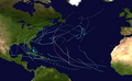
 of Hurricane Harvey</span>

Hurricane Harvey was the costliest tropical cyclone on record, inflicting roughly $125 billion in damage across the Houston metropolitan area and Southeast Texas. It lasted from mid-August until early September 2017, with many records for rainfall and landfall intensity set during that time. The eighth named storm, third hurricane, and first major hurricane of the 2017 Atlantic hurricane season, Harvey originated from a broad area of low pressure southwest of Cape Verde that was first monitored on August 13. Tracking steadily westward, the disturbance developed strong convection, a well-defined circulation, and sustained tropical storm-force winds, leading to the classification of Tropical Storm Harvey late on August 17. Moderate easterly vertical wind shear kept Harvey weak, as it continued westwards into the Caribbean Sea; despite repeated predictions for gradual intensification by the National Hurricane Center, Harvey eventually opened up into a tropical wave on August 19. The remnants of Harvey continued to move westwards and reached the Yucatán Peninsula on August 22, and were forecast to regenerate into a tropical cyclone after exiting land.

<span class="mw-page-title-main">2021 Atlantic hurricane season</span> Hurricane season in the Atlantic Ocean

The 2021 Atlantic hurricane season was the third-most active Atlantic hurricane season on record in terms of number of tropical cyclones, although many of them were weak and short-lived. With 21 named storms forming, it became the second season in a row and third overall in which the designated 21-name list of storm names was exhausted. Seven of those storms strengthened into a hurricane, four of which reached major hurricane intensity, which is slightly above-average. The season officially began on June 1 and ended on November 30. These dates historically describe the period in each year when most Atlantic tropical cyclones form. However, subtropical or tropical cyclogenesis is possible at any time of the year, as demonstrated by the development of Tropical Storm Ana on May 22, making this the seventh consecutive year in which a storm developed outside of the official season.

<span class="mw-page-title-main">Hurricane Barry (2019)</span> Category 1 Atlantic hurricane in 2019

Hurricane Barry was an asymmetrical Category 1 hurricane that was the wettest tropical cyclone on record in Arkansas and the fourth-wettest in Louisiana. The second tropical or subtropical storm and first hurricane of the 2019 Atlantic hurricane season, Barry originated as a mesoscale convective vortex over southwestern Kansas on July 2. The system eventually emerged into the Gulf of Mexico from the Florida Panhandle on July 10, whereupon the National Hurricane Center (NHC) designated it as a potential tropical cyclone. Early on July 11, the system developed into a tropical depression, and strengthened into a tropical storm later that day. Dry air and wind shear caused most of the convection, or thunderstorms, to be displaced south of the center. Nevertheless, Barry gradually intensified. On July 13, Barry attained its peak intensity as Category 1 hurricane with 1-minute sustained winds of 75 mph (120 km/h) and a minimum central pressure of 993 millibars (29.3 inHg). At 15:00 UTC, Barry made its first landfall at Marsh Island, and another landfall in Intracoastal City, Louisiana, both times as a Category 1 hurricane. Barry quickly weakened after landfall, falling to tropical depression status on July 15. The storm finally degenerated into a remnant low over northern Arkansas on the same day, subsequently opening up into a trough on July 16. The storm's remnants persisted for another few days, while continuing its eastward motion, before being absorbed into another frontal storm to the south of Nova Scotia on July 19.

<span class="mw-page-title-main">Tropical Storm Imelda</span> Atlantic tropical storm in 2019

Tropical Storm Imelda was a tropical cyclone which was the fourth-wettest storm on record in the U.S. state of Texas, causing devastating and record-breaking floods in southeast Texas. The eleventh tropical cyclone and ninth named storm of the 2019 Atlantic hurricane season, Imelda formed out of an upper-level low that developed in the Gulf of Mexico and moved westward. Little development occurred until the system was near the Texas coastline, where it rapidly developed into a tropical storm before moving ashore shortly afterward on September 17. Imelda weakened after landfall, but continued bringing large amounts of flooding rain to Texas and Louisiana, before dissipating on September 21.

<span class="mw-page-title-main">Tropical storms Amanda and Cristobal</span> East Pacific and Atlantic tropical storms in 2020

Tropical Storm Amanda and Tropical Storm Cristobal were two related, consecutive tropical storms that affected Central America, southern Mexico, the Central United States, and Canada in late May and early June 2020. The first tropical cyclone formed in the East Pacific and was named Amanda. After crossing Central America, it regenerated into a second one in the Gulf of Mexico and was named Cristobal. Amanda was the second tropical depression and the first named storm of the 2020 Pacific hurricane season, and Cristobal was the third named storm of the extremely active 2020 Atlantic hurricane season, and the earliest third named storm in the North Atlantic Ocean on record. Cristobal's regeneration date in the North Atlantic eclipsed the date set by Tropical Storm Colin in 2016, which formed on June 5. It was also the first Atlantic tropical storm formed in the month of June since Cindy in 2017, and the first June tropical cyclone to make landfall in Mexico since Danielle in 2016.

<span class="mw-page-title-main">Hurricane Marco (2020)</span> Category 1 Atlantic hurricane in 2020

Hurricane Marco was the first of two tropical cyclones to threaten the Gulf Coast of the United States within a three-day period. The thirteenth named storm and third hurricane of the record-breaking 2020 Atlantic hurricane season, Marco developed from a fast-moving tropical wave west of the Windward Islands and south of Jamaica on August 20. The fast motion of the wave inhibited intensification initially, but as the wave slowed down and entered a more favorable environment, the system developed into a tropical depression, which in turn rapidly intensified into a strong tropical storm. Due to strong wind shear, Marco's intensification temporarily halted. However, after entering the warm waters of the Gulf of Mexico on August 23, Marco briefly intensified into a hurricane, only to quickly weaken later that evening due to another rapid increase in wind shear. Marco subsequently weakened to a tropical depression before degenerating into a remnant low early the next morning. Marco's remnants subsequently dissipated on August 26.

<span class="mw-page-title-main">Hurricane Sally</span> Category 2 Atlantic hurricane in 2020

Hurricane Sally was a destructive and slow-moving Atlantic hurricane that was the first hurricane to make landfall in the U.S. state of Alabama since Ivan in 2004, coincidentally on the same date in the same place. The eighteenth named storm and seventh hurricane of the extremely active 2020 Atlantic hurricane season, Sally developed from an area of disturbed weather which was first monitored over the Bahamas on September 10. The system grew a broad area of low-pressure on September 11, and was designated as a tropical depression late that day. Early the next day, the depression made landfall at Key Biscayne and subsequently strengthened into Tropical Storm Sally that afternoon. Moderate northwesterly shear prevented significant intensification for the first two days, but convection continued to grow towards the center and Sally slowly intensified. On September 14, a center reformation into the center of the convection occurred, and data from a hurricane hunter reconnaissance aircraft showed that Sally had rapidly intensified into a strong Category 1 hurricane. However, an increase in wind shear and upwelling of colder waters halted the intensification and Sally weakened slightly on September 15 before turning slowly northeastward. Despite this increase in wind shear, it unexpectedly re-intensified, reaching Category 2 status early on September 16 before making landfall at peak intensity at 09:45 UTC on September 16, near Gulf Shores, Alabama, with maximum sustained winds of 110 mph (180 km/h) and a minimum central pressure of 965 millibars (28.5 inHg). The storm rapidly weakened after landfall before transitioning into an extratropical low at 12:00 UTC the next day. Sally's remnants lasted for another day as they moved off the coast of the Southeastern United States before being absorbed into another extratropical storm on September 18.

<span class="mw-page-title-main">Tropical Storm Beta (2020)</span> Atlantic tropical storm in 2020

Tropical Storm Beta was a tropical cyclone that brought heavy rainfall, flooding, and severe weather to the Southeastern United States in September 2020. The twenty-third tropical depression and twenty-third named storm of the record-breaking 2020 Atlantic hurricane season, Beta originally formed from a trough of low pressure that developed in the northeastern Gulf of Mexico on September 10. The low moved slowly southwestward, with development hampered initially by the development of nearby Hurricane Sally. After Sally moved inland over the Southeastern United States and weakened, the disturbance became nearly stationary in the southwestern Gulf, where it began to organize. By September 16, the storm had gained a low-level circulation center and had enough organization to be designated as Tropical Depression Twenty-Two. The system held its intensity for a day due to the influence of strong wind shear and dry air, before eventually attaining tropical storm strength. It slowly moved northward and intensified to a mid-range tropical storm before dry air and wind shear halted its intensification. Beta then became nearly stationary on September 19, before starting to move west towards the Texas coast the next day, weakening as it approached. On September 21, Beta made landfall near Matagorda Peninsula, Texas as a minimal tropical storm. It subsequently weakened to a tropical depression the next day before becoming post-tropical early on September 23. Its remnants moved northeastward, before the center elongated and merged with a cold front early on September 25.

<span class="mw-page-title-main">Hurricane Gamma</span> Category 1 Atlantic hurricane in 2020

Hurricane Gamma was a Category 1 hurricane that brought heavy rains, flooding, and landslides to the Yucatán Peninsula in early October 2020. The twenty-fifth depression, twenty-fourth named storm and ninth hurricane of the extremely active 2020 Atlantic hurricane season, Gamma developed from a vigorous tropical wave that had been monitored as it was entering the Eastern Caribbean on September 29. The wave moved westward and slowed down as it moved into the Western Caribbean, where it began to interact with a dissipating cold front. A low formed within the disturbance on October 1 and the next day, it organized into a tropical depression. It further organized into Tropical Storm Gamma early the next day. It continued to intensify and made landfall as a minimal hurricane near Tulum, Mexico, on October 3. It weakened over land before reemerging in the Gulf of Mexico. Gamma then briefly restrengthened some before being blasted by high amounts of wind shear, causing it to weaken again. It made a second landfall as a tropical depression in Nichili, Mexico on October 6 before dissipating as it was absorbed by the approaching Hurricane Delta.

<span class="mw-page-title-main">Hurricane Delta</span> Category 4 Atlantic hurricane in 2020

Hurricane Delta was the record-tying fourth named storm of 2020 to make landfall in Louisiana, as well as the record-breaking tenth named storm to strike the United States in that year. The twenty-sixth tropical cyclone, twenty-fifth named storm, tenth hurricane, and third major hurricane of the record-breaking 2020 Atlantic hurricane season, Delta formed from a tropical wave which was first monitored by the National Hurricane Center (NHC) on October 1. Moving westward, the tropical wave began to quickly organize. A well-defined center of circulation formed with sufficiently organized deep convection on October 4, and was designated as Tropical Depression Twenty-six and soon thereafter, Tropical Storm Delta. Extremely rapid intensification ensued throughout October 5 into October 6, with Delta becoming a Category 4 hurricane within 28 hours of attaining tropical storm status. The rate of intensification was the fastest in the Atlantic basin since Hurricane Wilma in 2005. After peaking in intensity however, an unexpected increase in wind shear and dry air quickly weakened the small storm before it made landfall in Puerto Morelos, Mexico as a Category 2 hurricane with 105 mph (169 km/h) winds. It weakened some more over land before emerging into the Gulf of Mexico, where it was downgraded to a Category 1 hurricane. After that, it began to restrengthen, regaining Category 3 status late on October 8. It then turned northward and reached a secondary peak intensity of 953 mbar (28.14 inHg) and winds of 120 mph early on October 9. Delta then began to turn more north-northeastward into an area of cooler waters, higher wind shear, and dry air, causing it to weaken back to Category 2 status. Delta then made landfall at 23:00 UTC near Creole, Louisiana with winds of 100 mph (160 km/h) and a pressure of 970 mbar (29 inHg). The storm began to weaken more rapidly after landfall, becoming post-tropical just 22 hours later.

<span class="mw-page-title-main">Hurricane Zeta</span> Category 3 Atlantic hurricane in 2020

Hurricane Zeta was a late-season major hurricane in 2020 that made landfall on the Yucatán Peninsula and then in southeastern Louisiana, the latest on record to do so at such strength in the United States. Zeta was the record-tying sixth hurricane of the year to make landfall in the United States. The twenty-seventh named storm, twelfth hurricane and fifth major hurricane of the extremely active 2020 Atlantic hurricane season, Zeta formed from a broad area of low pressure that formed in the western Caribbean Sea on October 19. After battling wind shear, the quasi-stationary low organized into Tropical Depression Twenty-Eight on October 24. The system strengthened into Tropical Storm Zeta early on October 25 before becoming a hurricane the next day as it began to move northwestward. Hurricane Zeta made landfall on the Yucatán Peninsula late on October 26 and weakened while inland to a tropical storm, before moving off the northern coast of the peninsula on October 27. After weakening due to dry air entrainment, Zeta reorganized and became a hurricane again, and eventually a Category 2 hurricane, as it turned northeastward approaching the United States Gulf Coast on October 28. It continued to strengthen until it reached its peak intensity as a major Category 3 hurricane with 115-mile-per-hour (185 km/h) sustained winds and a minimum pressure of 970 mbar (28.64 inHg) as it made landfall at Cocodrie, Louisiana, that evening. Zeta continued on through Mississippi and parts of Alabama with hurricane-force winds. Zeta gradually weakened as it accelerated northeastward, and became post-tropical on October 29, as it moved through central Virginia, dissipating shortly afterwards off the coast of New Jersey. After bringing accumulating snow to parts of New England, the extratropical low-pressure system carrying Zeta's remnant energy impacted the United Kingdom on November 1 and 2.

<span class="mw-page-title-main">Hurricane Ida</span> Category 4 Atlantic hurricane in 2021

Hurricane Ida was a deadly and extremely destructive Category 4 Atlantic hurricane in 2021 that became the second-most damaging and intense hurricane to make landfall in the U.S. state of Louisiana on record, behind Hurricane Katrina in 2005. In terms of maximum sustained winds at landfall, Ida tied 2020's Hurricane Laura and the 1856 Last Island hurricane as the strongest on record to hit the state. The remnants of the storm also caused a tornado outbreak and catastrophic flooding across the Northeastern United States. The ninth named storm, fourth hurricane, and second major hurricane of the 2021 Atlantic hurricane season, Ida originated from a tropical wave in the Caribbean Sea on August 23. On August 26, the wave developed into a tropical depression, which organized further and became Tropical Storm Ida later that day, near Grand Cayman. Amid favorable conditions, Ida intensified into a hurricane on August 27, just before moving over western Cuba. A day later, the hurricane underwent rapid intensification over the Gulf of Mexico, and reached its peak intensity as a strong Category 4 hurricane while approaching the northern Gulf Coast, with maximum sustained winds of 150 mph (240 km/h) and a minimum central pressure of 929 millibars (27.4 inHg). On August 29, the 16th anniversary of Hurricane Katrina making landfall, Ida made landfall near Port Fourchon, Louisiana, devastating the town of Grand Isle. Ida weakened steadily over land, becoming a tropical depression on August 30, as it turned northeastward. On September 1, Ida transitioned into a post-tropical cyclone as it accelerated through the Northeastern United States, breaking multiple rainfall records in various locations before moving out into the Atlantic on the next day. Afterward, Ida's remnant moved into the Gulf of St. Lawrence and stalled there for a couple of days, before being absorbed into another developing low-pressure area early on September 5.

References

  1. 1 2 3 4 5 6 Latto, Andy S. (March 1, 2022). Tropical Cyclone Report: Hurricane Nicholas (PDF) (Report). Miami, Florida: National Hurricane Center. Retrieved March 1, 2022.
  2. Brown, Daniel (September 9, 2021). Five-Day Graphical Tropical Weather Outlook (Report). Miami, Florida: National Hurricane Center. Retrieved September 12, 2021.
  3. Papin, Philippe (September 10, 2021). Five-Day Graphical Tropical Weather Outlook (Report). Miami, Florida: National Hurricane Center. Retrieved September 12, 2021.
  4. Henson, Bob; Masters, Jeff (September 12, 2021). "Tropical Storm Nicholas to douse Texas coast with torrential rains". New Haven, Connecticut: Yale Climate Connections. Retrieved September 12, 2021.
  5. Brown, Daniel (September 12, 2021). Tropical Storm Nicholas Discussion Number 1 (Report). Miami, Florida: National Hurricane Center. Retrieved September 12, 2021.
  6. Brown, Daniel (September 12, 2021). Tropical Storm Nicholas Discussion Number 3 (Report). Miami, Florida: National Hurricane Center. Retrieved September 12, 2021.
  7. Brown, Daniel (September 12, 2021). Tropical Storm Nicholas Discussion Number 4 (Report). Miami, Florida: National Hurricane Center. Retrieved September 12, 2021.
  8. Brown, Daniel (September 13, 2021). Tropical Storm Nicholas Discussion Number 5 (Report). Miami, Florida: National Hurricane Center. Retrieved September 13, 2021.
  9. Brown, Daniel (September 13, 2021). Tropical Storm Nicholas Discussion Number 6 (Report). Miami, Florida: National Hurricane Center. Retrieved September 13, 2021.
  10. 1 2 Masters, Jeff; Henson, Bob (September 14, 2021). "Nicholas brings debris, storm surge to Texas as Cat 1 hurricane". New Haven, Connecticut: Yale Climate Connections. Retrieved September 15, 2021.
  11. 1 2 Pasch, Richard; Blake, Eric; Papin, Philippe (September 13, 2021). Hurricane Nicholas Advisory Number 8...Corrected (Report). Miami, Florida: National Hurricane Center. Retrieved September 13, 2021.
  12. 1 2 "Hurricane Nicholas Makes Landfall On The Texas Coast". NPR. AP. September 14, 2021. Retrieved September 15, 2021.
  13. Blake, Eric (September 14, 2021). Tropical Storm Nicholas Discussion Number 9 (Report). Miami, Florida: National Hurricane Center. Retrieved September 14, 2021.
  14. Beven, Jack (September 14, 2021). Tropical Depression Nicholas Intermediate Advisory Number 11A (Report). Miami, Florida: National Hurricane Center. Retrieved September 16, 2021.
  15. "Nicholas Crawls Into Louisiana From Texas, Dumping Rain In Areas Struck By Ida". NPR. AP. September 15, 2021. Retrieved September 16, 2021.
  16. Beven, Jack (September 14, 2021). Tropical Depression Nicholas Discussion Number 12 (Report). Miami, Florida: National Hurricane Center. Retrieved September 16, 2021.
  17. Alex Lamers (September 16, 2021). Post-Tropical Cyclone Nicholas Advisory Number 17. www.nhc.noaa.gov (Report). College Park, Maryland: Weather Prediction Center. Retrieved September 22, 2021.
  18. "Nicholas Becomes Post-Tropical Near Marsh Island Along The Central Louisiana Coast". Orlando, Florida: WKMG-TV. September 16, 2021. Retrieved September 16, 2021.
  19. Greg Carbin (September 17, 2021). Post-Tropical Cyclone Nicholas Advisory Number 23. www.nhc.noaa.gov (Report). College Park, Maryland: Weather Prediction Center. Retrieved September 22, 2021.
  20. "WPC Surface Analysis valid for 09/18/2021 at 18 UTC". wpc.ncep.noaa.gov. Weather Prediction Center. September 18, 2021. Retrieved September 22, 2021.
  21. "WPC Surface Analysis valid for 09/18/2021 at 21 UTC". wpc.ncep.noaa.gov. Weather Prediction Center. September 18, 2021. Retrieved September 22, 2021.
  22. "Showers And Storms Will Continue Through Tuesday". Jackson, Tennessee: WBBJ-TV. September 18, 2021. Retrieved September 18, 2021.
  23. Morgan, Leigh (September 18, 2021). "Flooding rain possible for Alabama today". AL.com . Retrieved September 18, 2021.
  24. Cappucci, Matthew (September 22, 2021). "Forecasters eyeing new Atlantic tropical system set to be named 'Sam'". The Washington Post . Retrieved September 22, 2021.
  25. Bacon, John. "'Despondent': Battered Louisiana city gets more rain from Nicholas; 100,000 without power in Texas". USA TODAY. Retrieved 2023-03-01.
  26. Chappell, Bill (September 14, 2021). "Nicholas Puts More Than Half Of Louisiana On Flood Alert Despite Weakening". NPR.
  27. "Flash flood risk grows for coastal Texas and Louisiana as Tropical Storm Nicholas takes aim". CNN . September 13, 2021. Retrieved September 13, 2021.
  28. "LIST: CCISD and area school district closure status". September 12, 2021. Retrieved September 13, 2021.
  29. "Tropical Storm Nicholas 2021: Here's a list of school closures for South Texas". USA Today . September 12, 2021. Retrieved September 13, 2021.
  30. Seba, Erwin (2021-09-15). "Nicholas deluges U.S. Gulf Coast with heavy rain, flooding". Reuters. Retrieved 2023-03-01.
  31. 1 2 3 Holcombe, Madeline (September 14, 2021). "Nicholas threatens flooding in Texas and Louisiana after making landfall as a hurricane with 75-mph winds". CNN . Retrieved September 14, 2021.
  32. 1 2 3 4 5 6 Shapiro, Emily; Golembo, Max; Griffin, Melissa; Pereira, Ivan (September 14, 2021). "Tropical Storm Nicholas takes aim on hard-hit Louisiana: Latest path". ABC News . Retrieved September 14, 2021.
  33. 1 2 3 Ehling, Jeff (September 14, 2021). "Nicholas floods streets in historic Strand District in Galveston" . Retrieved September 14, 2021.
  34. "Louisiana declares state of emergency as Tropical Storm Nicholas targets battered region". USA Today . September 12, 2021. Retrieved September 13, 2021.
  35. "Biden approves Louisiana emergency declaration due to tropical storm Nicholas". Reuters. September 14, 2021. Retrieved September 14, 2021.
  36. Alexander, Chloe (September 13, 2021). "Gov. Abbott issues disaster declaration for 17 Texas counties ahead of Tropical Storm Nicholas" . Retrieved September 13, 2021.
  37. KTRK (2021-09-13). "Harry Styles concert at Toyota Center postponed due to Hurricane Nicholas". ABC13 Houston. Retrieved 2021-09-24.
  38. Bill, Chappell; Campbell, Barbara; Diaz, Jaclyn (September 14, 2021). "Hurricane Nicholas Makes Landfall In Texas. Residents Are Bracing For Possible Floods". NPR.
  39. 1 2 Panjwani, Lucio Vasquez, Paul DeBenedetto, Camilo Hannibal Smith, Sara Willa Ernst, Florian Martin, ShaVonne Herndon, Haya (2021-09-13). "Power Slowly Returns As Greater Houston Begins Nicholas Cleanup". Houston Public Media. Retrieved 2023-02-28.{{cite web}}: CS1 maint: multiple names: authors list (link)
  40. Evans, Steve (September 24, 2021). Hurricane Nicholas insured loss estimated up to $2.2bn by RMS. artemis.bm (Report). Retrieved September 26, 2021.
  41. Molinski, Dan (September 14, 2021). "Colonial Re-Shuts Fuel Pipelines, This Time Due to Hurricane Nicholas". Archived from the original on September 15, 2021. Retrieved September 14, 2021.
  42. Ferguson, Colleen (September 15, 2021). "Hurricane Nicholas destroys Seabrook's Pine Gully Fishing Pier". Community Impact. Retrieved September 23, 2021.
  43. Lozano, Juan (September 14, 2021). "Tropical Storm Nicholas slows, dumps rain along Gulf Coast" . Retrieved September 14, 2021.
  44. Fechter, Erin Douglas and Joshua (2021-09-14). "Texas sees limited damage in wake of Tropical Storm Nicholas as storm weakens and takes aim at Louisiana". The Texas Tribune. Retrieved 2023-03-01.
  45. Dick, Jacob (2021-09-14). "TS Nicholas pushes out of Southeast Texas". Beaumont Enterprise. Retrieved 2023-03-01.
  46. "LIST: High-water locations in Houston area due to Tropical Storm Nicholas". September 15, 2021. Retrieved September 15, 2021.
  47. Magee, Jake (September 14, 2021). "Tropical Storm Nicholas floods local roads". Community Impact. Retrieved September 23, 2021.
  48. Yanez, Andy; Magee, Jake (September 14, 2021). "Hurricane Nicholas destroys Seabrook's Pine Gully Fishing Pier". Community Impact. Retrieved September 23, 2021.
  49. Kollath Wells, Clarie (September 14, 2021). "Parking restrictions lifted in New Orleans as rain from Tropical Storm Nicholas reaches city". nola.com . Retrieved September 14, 2021.
Hurricane Nicholas
Nicholas 2021-09-14 0404Z.png
Hurricane Nicholas at peak intensity just before landfall in Texas early on September 14