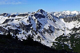
In-SHUCK-ch Mountain

Last updated
In-SHUCK-ch Mountain
In-shuck-ch Mountain.jpg
North aspect, from Mt. Taylor
Highest point
Elevation 2,386 m (7,828 ft) [1] [2]
Prominence 486 m (1,594 ft) [1]
Parent peak Wedge Mountain [2]
Isolation 8.27 km (5.14 mi) [1]
Listing Mountains of British Columbia
Coordinates 50°06′59″N122°35′37″W / 50.11639°N 122.59361°W / 50.11639; -122.59361 [3]
Geography
Canada British Columbia relief location map.jpg
Red triangle with thick white border.svg
In-SHUCK-ch Mountain
Location in British Columbia
Canada relief map 2.svg
Red triangle with thick white border.svg
In-SHUCK-ch Mountain
In-SHUCK-ch Mountain (Canada)
Country Canada
Province British Columbia
District New Westminster Land District [4]
Protected area Garibaldi Provincial Park
Parent range Coast Mountains [1]
Topo map NTS 92J2 Whistler
Climbing
First ascent 1967 John Clarke [5]

In-SHUCK-ch Mountain is a 2,386-metre (7,828-foot) summit in British Columbia, Canada.

Contents

Description

In-SHUCK-ch Mountain is located 26 kilometres (16 mi) east of Whistler in Garibaldi Provincial Park and the Coast Mountains. [1] [4] Precipitation runoff and glacial meltwater from this mountain drains into tributaries of the Lillooet River. In-SHUCK-ch Mountain is more notable for its steep rise above local terrain than for its absolute elevation as topographic relief is significant with the summit rising 2,186 metres (7,172 ft) above Little Lillooet Lake in four kilometres (2.5 mi).

History

The mountain was officially named Gunsight Peak in 1978, but officially changed on August 13, 1992, by the Geographical Names Board of Canada. [3] The name of the mountain is pronounced In-SHUCK-ch, meaning "split like a crutch", which refers to the split gap of the summit area. The people of the In-SHUCK-ch Nation took their name from this sacred mountain. [6] In-SHUCK-ch Mountain is significant in the origin stories of the people, as the mountain provided a refuge from a great flood. [3]

Climate

Based on the Köppen climate classification, In-SHUCK-ch Mountain is located in the marine west coast climate zone of western North America. [7] Most weather fronts originate in the Pacific Ocean, and travel east toward the Coast Mountains where they are forced upward by the range (orographic lift), causing them to drop their moisture in the form of rain or snowfall. As a result, the Coast Mountains experience high precipitation, especially during the winter months in the form of snowfall. Winter temperatures can drop below −20 °C with wind chill factors below −30 °C. This climate supports an unnamed glacier on the north slope of the peak. The months of July and August offer the most favorable weather for climbing or viewing In-SHUCK-ch Mountain.

See also

Related Research Articles

<span class="mw-page-title-main">Mount Taylor (British Columbia)</span> Mountain in the country of Canada

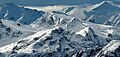
Mount Taylor is a 2,318-metre (7,605-foot) mountain summit located in the Coast Mountains, in Joffre Lakes Provincial Park, in southwestern British Columbia, Canada. It is part of the Joffre Group, which is a subset of the Lillooet Ranges. It is situated 21 km (13 mi) east of Pemberton, and 7 km (4 mi) northeast of Lillooet Lake. Its nearest higher peak is Slalok Mountain, 1.9 km (1 mi) to the east. Precipitation runoff from the peak drains into Joffre Creek, a tributary of the Lillooet River. The mountain's name was submitted by Karl Ricker of the Alpine Club of Canada to honor Ada C. Taylor, a Pemberton pioneer and the first nurse in that community. The toponym was officially adopted January 23, 1979, by the Geographical Names Board of Canada.

<span class="mw-page-title-main">Tremor Mountain</span> Mountain in the country of Canada

Tremor Mountain is a prominent 2,691-metre (8,829-foot) summit located in the Garibaldi Ranges of the Coast Mountains, in Garibaldi Provincial Park of southwestern British Columbia, Canada. It is the highest point of the Spearhead Range, which is a subset of the Garibaldi Ranges. It is situated 13 km (8 mi) southeast of Whistler, and 8.7 km (5 mi) south of Wedge Mountain, its nearest higher peak. Precipitation runoff from the south side of the peak as well as meltwater from the Platform Glacier drains into Fitzsimmons Creek which is a tributary of the Green River. Meltwater from the Tremor Glacier on the northwestern slope drains to Wedge Creek, and meltwater from the Shudder Glacier on the northeast slope drains into Billygoat Creek, a tributary of the Lillooet River. Tremor Mountain is often climbed as part of the Spearhead Traverse. The first ascent of the mountain was made in 1928 by A.J. Campbell Garibaldi survey party. The mountain's name origin refers to unexplained earth tremors when the first ascent party was on the summit. The mountain's toponym was officially adopted on September 6, 1951, by the Geographical Names Board of Canada.

<span class="mw-page-title-main">Duffey Peak</span> Mountain in British Columbia, Canada

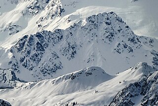
Duffey Peak is a 2,219-metre (7,280-foot) mountain summit located in southwest British Columbia, Canada.

<span class="mw-page-title-main">Handcar Peak</span> Mountain summit in British Columbia, Canada

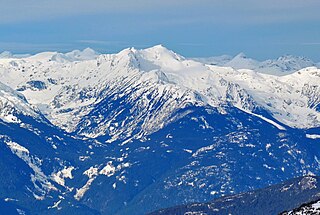
Handcar Peak is a 2,338-metre (7,671-foot) mountain summit located in the Railroad Group of the Coast Mountains, in the Pemberton Valley of southwestern British Columbia, Canada. It is situated 38 km (24 mi) northwest of Pemberton and 3 km (2 mi) west of Locomotive Mountain. Precipitation runoff from the peak drains into Sampson Creek and Buck Creek which are both tributaries of the Lillooet River. Handcar Peak is more notable for its steep rise above local terrain than for its absolute elevation as topographic relief is significant with the summit rising over 2,050 meters (6,725 ft) above Lillooet River and Pemberton Valley in approximately 4 km (2.5 mi). The mountain's name was proposed in 1978 by mountaineer Karl Ricker of the Alpine Club of Canada, in association with Railroad Pass, Railroad Creek and other railroad-related names of the immediate vicinity. The toponym was officially adopted January 23, 1979, by the Geographical Names Board of Canada.

<span class="mw-page-title-main">Ipsoot Mountain</span> Glaciated summit in southwest British Columbia, Canada

Ipsoot Mountain is a 2,576-metre (8,451-foot) glaciated summit located in southwest British Columbia, Canada.

<span class="mw-page-title-main">Rhododendron Mountain</span> Mountain in British Columbia, Canada

Rhododendron Mountain is a 2,523-metre (8,278-foot) glaciated summit in British Columbia, Canada.

<span class="mw-page-title-main">Cloudraker Mountain</span> Mountain in British Columbia, Canada

Cloudraker Mountain is a 2,385-metre (7,825-foot) glaciated summit in British Columbia, Canada.

Whitecap Mountain is a 2,918-metre (9,573-foot) summit in British Columbia, Canada.

<span class="mw-page-title-main">Mount Sir Richard</span> Mountain in British Columbia, Canada

Mount Sir Richard is a 2,681-metre (8,796-foot) glaciated summit in British Columbia, Canada.

<span class="mw-page-title-main">The Lecture Cutters</span> Mountains in British Columbia, Canada

The Lecture Cutters are 2,524-metre (8,281-foot) mountain peaks in British Columbia, Canada.

<span class="mw-page-title-main">Outlier Peak</span> Mountain in British Columbia, Canada

Outlier Peak is a 2,422-metre (7,946-foot) mountain summit in British Columbia, Canada.

<span class="mw-page-title-main">Nivalis Mountain</span> Mountain in British Columbia, Canada

Nivalis Mountain is a 2,659-metre (8,724-foot) mountain summit in British Columbia, Canada.

<span class="mw-page-title-main">Mount Neal</span> Mountain in British Columbia, Canada

Mount Neal is a 2,552-metre (8,373-foot) glaciated summit in British Columbia, Canada.

<span class="mw-page-title-main">Carcajou Peak</span> Mountain in British Columbia, Canada

Carcajou Peak is a 2,239-metre (7,346-foot) mountain summit in British Columbia, Canada.

<span class="mw-page-title-main">Mount Moe</span> Mountain in British Columbia, Canada

Mount Moe is a 2,664-metre (8,740-foot) glaciated summit in British Columbia, Canada.

<span class="mw-page-title-main">Twin Goat Mountain</span> Mountain in British Columbia, Canada

Twin Goat Mountain is a 2,128-metre (6,982-foot) summit in British Columbia, Canada.

<span class="mw-page-title-main">Shudder Mountain</span> Mountain in British Columbia, Canada

Shudder Mountain is a 2,671-metre (8,763-foot) summit in British Columbia, Canada.

<span class="mw-page-title-main">Icecap Peak</span> Mountain in British Columbia, Canada

Icecap Peak is a 2,435-metre (7,989-foot) glaciated summit in British Columbia, Canada.

<span class="mw-page-title-main">Klowa Mountain</span> Mountain in British Columbia, Canada

Klowa Mountain is a 2,527-metre (8,291-foot) summit in British Columbia, Canada.

<span class="mw-page-title-main">Mount Pitt</span> Summit in British Columbia, Canada

Mount Pitt is a 2,487-metre (8,159-foot) summit in British Columbia, Canada.

References

  1. 1 2 3 4 5 "In-shuck-ch Mountain, British Columbia". Peakbagger.com. Retrieved 2024-03-05.
  2. 1 2 "In-SHUCK-ch Mountain, Peakvisor.com" . Retrieved 2024-03-05.
  3. 1 2 3 "In-SHUCK-ch Mountain". BC Geographical Names .
  4. 1 2 "In-SHUCK-ch Mountain". Geographical Names Data Base . Natural Resources Canada . Retrieved 2024-03-05.
  5. Climbers You Should Know About: John Clarke, Gripped, January 26, 2021. Retrieved 2024-03-05.
  6. William C. Sturtevant, Handbook of North American Indians: Plateau, 1998, Smithsonian Institution, ISBN   9780140495140, p. 189.
  7. Peel, M. C.; Finlayson, B. L.; McMahon, T. A. (2007). "Updated world map of the Köppen−Geiger climate classification". Hydrol. Earth Syst. Sci. 11 (5): 1633. Bibcode:2007HESS...11.1633P. doi: 10.5194/hess-11-1633-2007 . ISSN   1027-5606.