Mount Neal

Last updated
Mount Neal
Mount Neal.jpg
Northeast aspect, from Mt. Taylor
Highest point
Elevation 2,552 m (8,373 ft) [1]
Prominence 481 m (1,578 ft) [2]
Parent peak Wedge Mountain [1]
Isolation 3.93 km (2.44 mi) [2]
Listing Mountains of British Columbia
Coordinates 50°09′16″N122°41′37″W / 50.15444°N 122.69361°W / 50.15444; -122.69361 [3]
Naming
Etymology Neal Carter
Geography
Canada British Columbia relief location map.jpg
Red triangle with thick white border.svg
Mount Neal
Location in British Columbia
Canada relief map 2.svg
Red triangle with thick white border.svg
Mount Neal
Mount Neal (Canada)
Location British Columbia, Canada
District Lillooet Land District [3]
Protected area Garibaldi Provincial Park
Parent range Coast Mountains [2]
Topo map NTS 92J2 Whistler
Climbing
First ascent 1949

Mount Neal is a 2,552-metre (8,373-foot) glaciated summit in British Columbia, Canada.

Contents

Description

Mount Neal is located in the Coast Mountains, and 23 kilometres (14 mi) east-northeast of Whistler in Garibaldi Provincial Park. [3] Precipitation runoff and glacial meltwater from this mountain's slopes drains to the Lillooet River via Ure, Kakila, and Chaos creeks. [2] Mount Neal is more notable for its steep rise above local terrain than for its absolute elevation as topographic relief is significant with the summit rising 1,250 metres (4,100 ft) above Chaos Creek in three kilometres (1.9 mi).

History

The mountain was named in 1929 by A.J. Campbell to honor Neal Carter (1902–1978), in recognition of Carter's excellent mapping of a large section of Garibaldi Park in the early days as a mountaineer. [4] Carter was a prominent member of the British Columbia Mountaineering Club and was credited with many first ascents in Garibaldi Park in 1922–23. The toponym was officially adopted October 4, 1932, by the Geographical Names Board of Canada. [4]

The first ascent of the summit was made September 6, 1949, by three members of the University of British Columbia's Varsity Outdoor Club: Arnie Ede, Fleming McConnell, and Bob Nicholson. [5]

Climate

Based on the Köppen climate classification, Mount Neal is located in the marine west coast climate zone of western North America. [6] Most weather fronts originate in the Pacific Ocean, and travel east toward the Coast Mountains where they are forced upward by the range (orographic lift), causing them to drop their moisture in the form of rain or snowfall. As a result, the Coast Mountains experience high precipitation, especially during the winter months in the form of snowfall. Winter temperatures can drop below −20 °C with wind chill factors below −30 °C. This climate supports the Carter Glacier on the east slope of the peak, as well as the Needles Glacier to the west. The months of July and August offer the most favorable weather for climbing Mount Neal.

See also

Related Research Articles

<span class="mw-page-title-main">Mount Fitzsimmons (British Columbia)</span> Mountain in the country of Canada

Mount Fitzsimmons is a 2,603-metre (8,540-foot) glacier-clad peak located in the Garibaldi Ranges of the Coast Mountains, in Garibaldi Provincial Park of southwestern British Columbia, Canada. It is the third-highest point of the Fitzsimmons Range, which is a subset of the Garibaldi Ranges. It is situated 15 km (9 mi) southeast of Whistler, and its nearest higher peak is Mount Benvolio, 0.5 km (0 mi) to the west-southwest. The Diavolo Glacier spreads out below the southeast aspect of the summit, and the Fitzsimmons Glacier descends the northwest slopes. Precipitation runoff from the peak and meltwater from its glaciers drains into tributaries of the Cheakamus River. The first ascent of the mountain was made on August 19, 1924, by a party of the British Columbia Mountaineering Club. The peak was named for prospector James Fitzsimmons, who built a trail along Fitzsimmons Creek in an effort to haul supplies to a small copper mine he staked and worked. The mountain's name was officially adopted on September 2, 1930, by the Geographical Names Board of Canada.

<span class="mw-page-title-main">Mount Macbeth</span> Mountain in British Columbia, Canada

Mount Macbeth is a 2,639-metre (8,658-foot) glacier-clad peak located in the Garibaldi Ranges of the Coast Mountains, in Garibaldi Provincial Park of southwestern British Columbia, Canada. It is part of the Spearhead Range, which is a subset of the Garibaldi Ranges. It is situated 14 km (9 mi) southeast of Whistler, and 2 km (1 mi) south of Tremor Mountain, which is the highest point in the Spearhead Range. The Naden Glacier spreads out below the eastern aspect of the summit, the Macbeth Glacier lies below the south aspect, and the Curtain Glacier descends the northern slope. Precipitation runoff from the peak and meltwater from its glaciers drains into Fitzsimmons Creek which is a tributary of the Cheakamus River. Macbeth is most often climbed as part of the Spearhead Traverse. The first ascent of the mountain was made in 1969 by P. Starr, E. Bass, B. Ellis, and P. Macec via the northeast ridge. The peak was named in 1964 by an Alpine Club of Canada climbing party, to commemorate the 400th anniversary of William Shakespeare's birth. The mountain's name was officially adopted on August 27, 1965, by the Geographical Names Board of Canada.

<span class="mw-page-title-main">Mount Davidson (British Columbia)</span> Mountain in the country of Canada

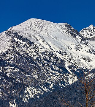
Mount Davidson is a 2,516-metre (8,255-foot) mountain summit located in the Garibaldi Ranges of the Coast Mountains, in Garibaldi Provincial Park of southwestern British Columbia, Canada. Visible from the Whistler Blackcomb ski area, it is situated 18 km (11 mi) south of Whistler, and its nearest higher peak is Castle Towers Mountain, 3 km (2 mi) to the west. The Cheakamus Glacier lies between these two summits, and precipitation runoff from the peak and meltwater from the glacier drains into tributaries of the Cheakamus River. The first ascent of the mountain was made in 1929 by Neal M. Carter and Emmy Milledge. The mountain is named after Professor John Davidson, who contributed a large amount of botanical knowledge about Garibaldi Park. The mountain's name was officially adopted on September 2, 1930, by the Geographical Names Board of Canada.

<span class="mw-page-title-main">Tremor Mountain</span> Mountain in the country of Canada

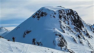
Tremor Mountain is a prominent 2,691-metre (8,829-foot) summit located in the Garibaldi Ranges of the Coast Mountains, in Garibaldi Provincial Park of southwestern British Columbia, Canada. It is the highest point of the Spearhead Range, which is a subset of the Garibaldi Ranges. It is situated 13 km (8 mi) southeast of Whistler, and 8.7 km (5 mi) south of Wedge Mountain, its nearest higher peak. Precipitation runoff from the south side of the peak as well as meltwater from the Platform Glacier drains into Fitzsimmons Creek which is a tributary of the Green River. Meltwater from the Tremor Glacier on the northwestern slope drains to Wedge Creek, and meltwater from the Shudder Glacier on the northeast slope drains into Billygoat Creek, a tributary of the Lillooet River. Tremor Mountain is often climbed as part of the Spearhead Traverse. The first ascent of the mountain was made in 1928 by A.J. Campbell Garibaldi survey party. The mountain's name origin refers to unexplained earth tremors when the first ascent party was on the summit. The mountain's toponym was officially adopted on September 6, 1951, by the Geographical Names Board of Canada.

<span class="mw-page-title-main">Mount Cook (British Columbia)</span> Mountain in the country of Canada

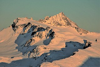
Mount Cook is a 2,676-metre (8,780-foot) mountain located in the Garibaldi Ranges of the Coast Mountains, in northwestern Garibaldi Provincial Park of southwestern British Columbia, Canada. It is situated above the north shore of Wedgemount Lake, 13 km (8 mi) northeast of Whistler, and its nearest higher peak is Mount Weart, 1.2 km (1 mi) to the southeast. The Armchair Glacier is set between Cook and Weart, and the Weart Glacier rests on the northern slope of Cook. Precipitation runoff from the peak and meltwater from the glaciers drains into Wedgemount Lake and Green River.

<span class="mw-page-title-main">Mount Trorey</span> Mountain in the country of Canada

Mount Trorey is a 2,461-metre (8,074-foot) mountain summit located in British Columbia, Canada.

<span class="mw-page-title-main">Mount James Turner</span> Mountain summit in British Columbia, Canada

Mount James Turner is a 2,703-metre (8,868-foot) mountain summit located in British Columbia, Canada.

<span class="mw-page-title-main">Mount Carr</span> Mountain in the country of Canada

Mount Carr is a 2,590-metre (8,497-foot) mountain summit located in British Columbia, Canada.

<span class="mw-page-title-main">Isosceles Peak</span> Mountain in the country of Canada

Isosceles Peak is a 2,488-metre (8,163-foot) mountain summit located in British Columbia, Canada.

<span class="mw-page-title-main">Phyllis's Engine</span> Mountain in the country of Canada

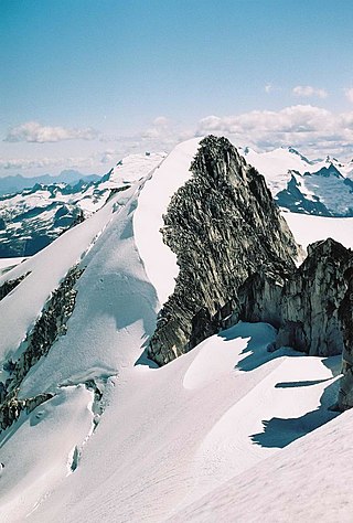
Phyllis's Engine is a 2,517-metre (8,258-foot) granite pinnacle located in British Columbia, Canada.

<span class="mw-page-title-main">Whirlwind Peak</span> Mountain in British Columbia, Canada

Whirlwind Peak is a 2,427-metre (7,963-foot) mountain summit in southwestern British Columbia, Canada.

<span class="mw-page-title-main">Parapet Peak (Garibaldi Provincial Park)</span> Mountain in the country of Canada

Parapet Peak is a 2,463-metre (8,081-foot) mountain summit located in British Columbia, Canada.

<span class="mw-page-title-main">Deception Peak</span> Mountain in the country of Canada

Deception Peak is a 2,233-metre (7,326-foot) summit in British Columbia, Canada.

<span class="mw-page-title-main">Mount Sir Richard</span> Mountain in British Columbia, Canada

Mount Sir Richard is a 2,681-metre (8,796-foot) glaciated summit in British Columbia, Canada.

<span class="mw-page-title-main">Outlier Peak</span> Mountain in British Columbia, Canada

Outlier Peak is a 2,422-metre (7,946-foot) mountain summit in British Columbia, Canada.

<span class="mw-page-title-main">Nivalis Mountain</span> Mountain in British Columbia, Canada

Nivalis Mountain is a 2,659-metre (8,724-foot) mountain summit in British Columbia, Canada.

<span class="mw-page-title-main">Carcajou Peak</span> Mountain in British Columbia, Canada

Carcajou Peak is a 2,239-metre (7,346-foot) mountain summit in British Columbia, Canada.

<span class="mw-page-title-main">Mount Moe</span> Mountain in British Columbia, Canada

Mount Moe is a 2,664-metre (8,740-foot) glaciated summit in British Columbia, Canada.

<span class="mw-page-title-main">Shudder Mountain</span> Mountain in British Columbia, Canada

Shudder Mountain is a 2,671-metre (8,763-foot) summit in British Columbia, Canada.

<span class="mw-page-title-main">Mount Pitt</span> Summit in British Columbia, Canada

Mount Pitt is a 2,487-metre (8,159-foot) summit in British Columbia, Canada.

References

  1. 1 2 "Mount Neal, Peakvisor.com" . Retrieved 2024-03-04.
  2. 1 2 3 4 "Mount Neal, British Columbia". Peakbagger.com. Retrieved 2024-03-06.
  3. 1 2 3 "Mount Neal". Geographical Names Data Base . Natural Resources Canada . Retrieved 2024-03-06.
  4. 1 2 "Mount Neal". BC Geographical Names .
  5. Rich So, Mount James Turner, Alpinebaking.com, June 5, 2007, Retrieved 2024-03-06.
  6. Peel, M. C.; Finlayson, B. L.; McMahon, T. A. (2007). "Updated world map of the Köppen−Geiger climate classification". Hydrol. Earth Syst. Sci. 11 (5): 1633. Bibcode:2007HESS...11.1633P. doi: 10.5194/hess-11-1633-2007 . ISSN   1027-5606.