
Washington County is a county located in the U.S. state of Tennessee. As of the 2010 census, the population was 122,979. Its county seat is Jonesborough. The county's largest city and a regional educational, medical and commercial center is Johnson City. Washington County is Tennessee's oldest county, having been established in 1777 when the state was still part of North Carolina.

Johnson County is a county located in the U.S. state of Kentucky. As of the 2010 census, the population was 23,356. Its county seat is Paintsville. The county was formed in 1843 and named for Richard Mentor Johnson, War of 1812 general, United States Representative, Senator, and Vice President of the United States. Johnson County is classified as a moist county, which is a county in which alcohol sales are not allowed, but containing a "wet" city, in this case Paintsville, where alcoholic beverage sales are allowed.
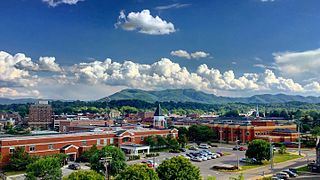
Johnson City is a city in Washington, Carter, and Sullivan counties in the U.S. state of Tennessee, with most of the city being in Washington County. As of the 2010 census, the population of Johnson City was 63,152, and by 2017 the estimated population was 66,391, making it the ninth-largest city in the state.

Edward "Allegheny" Johnson was a United States Army officer and Confederate general in the American Civil War. Highly rated by Robert E. Lee, he was made a divisional commander under Richard S. Ewell. On the first evening of the Battle of Gettysburg, Ewell missed his opportunity to attack Cemetery Hill, and Johnson opted against attacking Culp's Hill, for which he had a discretionary order, though he attempted this on the second and third days. Ewell and Johnson are blamed by many for the loss of this decisive battle.

Sleepy Creek Mountain is a mountain ridge in the Ridge-and-Valley Appalachians on the border between Morgan and Berkeley counties in the Eastern Panhandle of West Virginia. The long-distance Tuscarora Trail traverses the southern ridge and northern bench of the mountain.

Johnson's Harbour is a settlement on the north east coast of East Falkland in the Falkland Islands. It is on the shore of Berkeley Sound at the head of Chabot Creek on a bay also named Johnson's Harbour. It has a small store but the FIGAS only lands there for emergencies. Surrounding hills include North Lookout, Diamond Mountain and Hawk Hill.
Johnson Siding is an unincorporated community in Pennington County, South Dakota, United States. The population as of the 2010 census was 659. It is located in the Rimrock Area, about 10 miles west of Rapid City. It is surrounded by the Black Hills National Forest. It is the only significant business district in the Rimrock Area, with a gas station/general store, deli, casino, tavern, the Johnson Siding Volunteer Fire Department firehouse, the Rimrock Evangelical Free Church meetinghouse, and a community center. However, most inhabitants work in Rapid City or Deadwood.

Beinn na Caillich, west of Broadford on the Isle of Skye, is one of the Red Hills, or Red Cuillin. Its name is translated into English as Hill of the Old Woman. It is often referred to locally simply as The Beinn.

Alander Mountain, 2,239 feet (682 m), is a prominent peak of the south Taconic Mountains; it is located in southwest Massachusetts and adjacent New York. Part of the summit is grassy and open and part is covered with scrub oak and shrubs; the sides of the mountain are wooded with northern hardwood tree species. Views from the top include the southern Taconic Mountains, the Hudson River Valley including the Catskills. Several trails traverse Alander Mountain, most notably the 15.7 mi (25.3 km) South Taconic Trail, which passes just beneath the summit.

The New River Mountains are a small 14-mi (23 km) long, mountain range in central Arizona, and on the north border of the Phoenix valley; the range is located on the southwest perimeter of the Arizona transition zone. The range is a sub-part of landforms extending south from the Black Hills of Yavapai County. Rivers and canyons border east and west; the south of the range is located in Maricopa County, the location of much of the Phoenix metropolitan area.

The Santa Maria Mountains are a 16-mi (26 km) long mountain range in central-northwest Arizona, and in northwest Yavapai County. The range lies in a region of mesas and mountain ranges in the northwest of Arizona's transition zone. The Santa Maria Mountains lie east of the transition zone's northwest perimeter, the parallel Aquarius and Mohon Mountains.

Rum Hill is a mountain located in Central New York Region of New York northwest of the Hamlet of Pierstown. Red House Hill is located southeast, Metcalf Hill is located south, Allen Lake and Mohegan Hill are located north-northwest and Otsego Lake is located east of Rum Hill.

Gross Hill is a mountain in the Central New York Region of New York. It is located northwest of Garrattsville, New York. Crystal Lake is located south and Wooley Hill is located northeast of Gross Hill.
Fox Hill is a mountain located in Adirondack Mountains of New York located in the Town of Indian Lake east of Indian Lake.
Wilders Hill is a mountain located in Central New York Region of New York east of Richfield Springs, New York. Waiontha Mountain is located southeast of Wilders Hill.
Lumbert Hill is a mountain located in the Catskill Mountains of New York west of Delhi. Dunk Hill is located southwest, The Cobble is located south, and Johnson Hill is located west of Lumbert Hill.
Red Hill is a mountain located in the Catskill Mountains of New York east-south of Frost Valley. Woodhull Mountain is located northeast of Red Hill.
Van Loan Hill is a mountain in Greene County, New York. It is located in the Catskill Mountains southwest of Maplecrest. Round Hill is located west, Elm Ridge is located north-northeast, and East Jewett Range is located south of Van Loan Hill.
Mount Johnson, Johnson Mountain, Johnson Peak, or variation, may refer to:


