
Hawaii is the largest island in the United States, located in the state of Hawaii. It is the southeasternmost of the Hawaiian Islands, a chain of volcanic islands in the North Pacific Ocean. With an area of 4,028 square miles (10,430 km2), it has 63% of the Hawaiian archipelago's combined landmass. However, it has only 13% of Hawaiʻi's population. The island of Hawaiʻi is the third largest island in Polynesia, behind the north and south islands of New Zealand.

Kailua-Kona is an unincorporated community and census-designated place (CDP) in Hawaii County, Hawaii, United States. It is also known as Kailua, as Kona and as Kona Town. Kailua-Kona is the second-largest settlement on the island of Hawaii and the largest on the island's west side, where it is the center of commerce and the tourist industry. Kailua-Kona is served by Kona International Airport, just to the north in the adjacent CDP of Kalaoa. The population was 19,713 at the 2020 census, up from 11,975 at the 2010 census.
The following is an alphabetical list of articles related to the U.S. state of Hawaii:
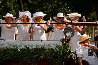
The Daughters of Hawaiʻi was founded in 1903 by seven women who were daughters of American Protestant missionaries. They were born in Hawaiʻi, were citizens of the Kingdom of Hawaiʻi before annexation, and foresaw the inevitable loss of much of the Hawaiian culture. They founded the organization "to perpetuate the memory and spirit of old Hawaiʻi and of historic facts, and to preserve the nomenclature and correct pronunciation of the Hawaiian language."' They run the Huliheʻe Palace and the Queen Emma Summer Palace.
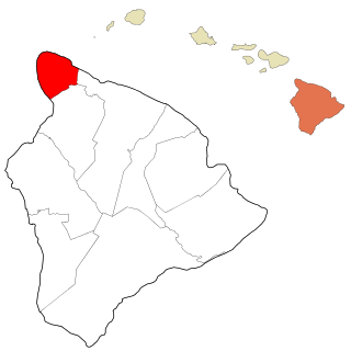
Kohala is the name of the northwest peninsula of the island of Hawaiʻi in the Hawaiian Archipelago. In ancient Hawaii it was often ruled by an independent High Chief called the Aliʻi Nui. In modern times it is divided into two districts of Hawaii County: North Kohala and South Kohala. Locals commonly use the name Kohala to refer to the census-designated places of Halaʻula, Hāwī, and Kapaʻau collectively. The dry western shore is commonly known as the Kohala Coast, which has golf courses and seaside resorts.

Kealakekua Bay is located on the Kona coast of the island of Hawaiʻi about 12 miles (19 km) south of Kailua-Kona. Settled over a thousand years ago, the surrounding area contains many archeological and historical sites such as religious temples (heiaus) and also includes the spot where the first documented European to reach the Hawaiian islands, Captain James Cook, was killed. It was listed in the National Register of Historic Places listings on the island of Hawaii in 1973 as the Kealakekua Bay Historical District. The bay is a marine life conservation district, a popular destination for kayaking, scuba diving, and snorkeling.

Kohala Historical Sites State Monument includes the National Historic Landmark Moʻokini Heiau and the birthplace of Kamehameha I. It is located in remote North Kohala on the Island of Hawaiʻi.
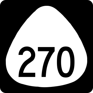
The ʻAkoni Pule Highway, designated as Hawaiʻi Route 270, is a state highway in Hawaii County, Hawaii, United States, that is the main road along the North Kohala Coast on the Island of Hawaiʻi from Kawaihae to ʻUpolu Point and then on to Pololū Valley Lookout. The entire route is 27.0 miles (43.5 km) long.
Kawaihae is an unincorporated community on the west side of the island of Hawaiʻi in the U.S. state of Hawaiʻi, 35 miles (56 km) north of Kailua-Kona. Its harbor is one of only three on the island, together with that of Hilo and Honokohau Harbor.
The Hawaiʻi Belt Road is a modern name for the Māmalahoa Highway and consists of Hawaiʻi state Routes 11, 19, and 190 that encircle the Island of Hawaiʻi. The southern section, between Hilo and Kailua-Kona is numbered as Route 11. The section between Hilo and Waimea is Route 19. Between Waimea and Kailua-Kona, the road is split in two: the original "mauka" route and a "makai" Route 19, completed in 1975, which serves as access to the Kona and Kohala Coast resorts. In the Hawaiian language, mauka means "towards the mountain" and makai means "towards the sea". These terms are commonly used in travel directions.
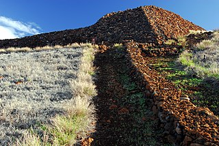
Puʻukoholā Heiau National Historic Site is a United States National Historic Site located on the northwestern coast of the island of Hawaiʻi. The site preserves the National Historic Landmark ruins of the last major Ancient Hawaiian temple, and other historic sites.

Kamakahonu, the residence of Kamehameha I, was located at the north end of Kailua Bay in Kailua-Kona on Hawaiʻi Island.

Keauhou is an unincorporated community on the island of Hawaii in Hawaii County, Hawaii, United States. Its elevation is 13 feet (4 m). Because the community has borne multiple names, the Board on Geographic Names officially designated it "Keauhou" in 1914. It has a post office with the ZIP code 96739. The post office is a contract station only; people who live in the community use the zip code of 96740 or 96725.

Keauhou Bay is a historic area in the Kona District of the Big Island of Hawaiʻi. The name comes from ke au hou which means "the new era" in the Hawaiian Language.

The Kuamoʻo Burials is an historic Hawaiian burial site for warriors killed during a major battle in 1819. The site is located at Kuamoʻo Bay in the North Kona District, on the island of Hawaiʻi, United States.

Hōlualoa Bay is a historic area between Kailua-Kona and Keauhou Bay in the Kona District of the Big Island of Hawaiʻi. The community now called Hōlualoa is uphill from this bay. The name means "long slide" in the Hawaiian Language, from the long trail that went from a forest on the slopes of Hualālai, to a site where the logs were made into canoes into this bay where a large royal building complex was built over several centuries.

Waikoloa Beach is an area located on the South Kohala coast on the island of Hawaii and is located in the census-designated place of Puako. It can be confused for Waikoloa Village, a CDP in the same "ahupuaʻa" and is also known as "Waikoloa".

Kaunaʻoa Bay has one of the few white sand beaches of the Kohala Coast, the western side of the island of Hawaiʻi. A historic hotel, the Mauna Kea Beach Hotel, is located on beautiful Kauna'oa.

There are 75 golf courses in Hawaii.
Aliʻi Drive is the main street of Kailua-Kona, Island of Hawaii, United States.
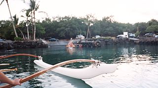
 The County Park is a popular snorkeling spot
 St. Peter by the Sea Catholic Church
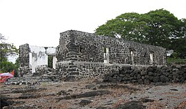 Ruins of 1860 Helani Church
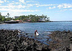 Ancient canoe landing still used by surfers
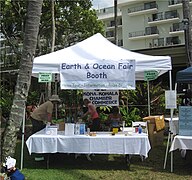 Kona Earth Festival Ocean Fair 2009
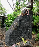 Kuʻula stones were monuments to the plentiful fish
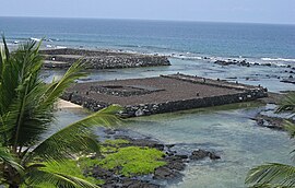 Hāpaialiʻi Heiau was restored in 2007
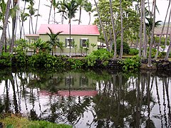 Reconstructed King Kalākaua beach house on Poʻo Hawaiʻi
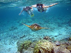 Two snorkelers swimming with a Green sea turtle in Kahaluu Beach Park


