
Cleveland is a city in the U.S. state of Ohio and the county seat of Cuyahoga County. Located along the southern shore of Lake Erie, it is situated across the Canada–United States maritime border and lies approximately 60 mi (97 km) west of Pennsylvania. Cleveland is the most populous city on Lake Erie, the second-most populous city in Ohio, and the 54th-most populous city in the U.S. with a population of 372,624 in 2020. The city anchors the Cleveland metropolitan area, the 33rd-largest in the U.S. at 2.18 million residents, as well as the larger Cleveland–Akron–Canton combined statistical area with 3.63 million residents.

Cuyahoga County is a large urban county located in the northeastern part of the U.S. state of Ohio. The county seat and largest city is Cleveland. As of the 2020 census, its population was 1,264,817, making it the second-most populous county in the state.

Lakewood is a city in Cuyahoga County, Ohio, United States, on the southern shore of Lake Erie. Established in 1889, it is one of Cleveland's historical streetcar suburbs and part of the Cleveland metropolitan area. The population was 50,942 at the 2020 census, making it the third largest city in Cuyahoga County, behind Cleveland and Parma.
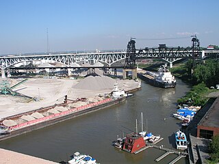
The Flats is a mixed-use industrial, recreational, entertainment, and residential area of the Cuyahoga Valley neighborhood of Cleveland, Ohio, U.S. The name reflects its low-lying topography on the banks of the Cuyahoga River.
Downtown Cleveland is the central business district of Cleveland, Ohio, United States. The economic and cultural center of the city and the Cleveland metropolitan area, it is Cleveland's oldest district, with its Public Square laid out by city founder General Moses Cleaveland in 1796.

Cleveland Metroparks is an extensive system of nature preserves in Greater Cleveland, Ohio. Eighteen reservations, which largely encircle the city of Cleveland, follow along the shore of Lake Erie and the rivers and creeks that flow through the region. Referred to unofficially as the 'Emerald Necklace', the network of parks spans over 25,000 acres (10,000 ha) and includes over 300 miles (480 km) of walking, bicycle, and horse trails as well as numerous picnic areas, nature education centers, golf courses, and countless fishing spots. In addition, the district includes the zoo in Cleveland. Four of the reservations are adjacent to Cuyahoga Valley National Park.

The city of Cleveland, Ohio, was founded by General Moses Cleaveland of the Connecticut Land Company on July 22, 1796. Its central location on the southern shore of Lake Erie and the mouth of the Cuyahoga River allowed it to become a major center for Great Lakes trade in northern Ohio in the early 19th century. An important Northern city during the American Civil War, Cleveland grew into a major industrial metropolis and a gateway for European and Middle Eastern immigrants, as well as African American migrants, seeking jobs and opportunity.
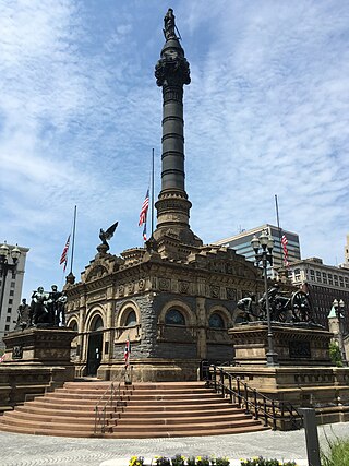
The Cuyahoga County Soldiers' and Sailors' Monument is a major Civil War monument in Cleveland, Ohio, honoring the more than 9,000 individuals from Cuyahoga County who served the Union throughout the war. It was dedicated on July 4, 1894, and is located on the southeast quadrant of Public Square in Downtown Cleveland. It was designed by architect and Civil War veteran Levi Scofield, who also created the monument's sculptures. The monument is regularly open to the public, free of charge.

Cuyahoga County, Ohio, United States is divided into 21 townships.
The MetroHealth System is a non-profit, public health care system located in Cleveland, Ohio. Founded in 1837 as City Hospital, The MetroHealth System serves the residents of the city of Cleveland and Cuyahoga County. It is one of the three major health care systems in Cleveland, Ohio, along with Cleveland Clinic and University Hospitals of Cleveland.

Jefferson is a neighborhood on the West Side of Cleveland, Ohio. It is bounded by the neighborhoods of West Boulevard and Cudell and the village of Linndale to the east, Bellaire–Puritas to the south, Kamm's Corners to the west, and the streetcar suburb of Lakewood to the north. It is one of four sub-neighborhoods that comprise the larger historical neighborhood of West Park, the others being Kamm's Corners, Bellaire–Puritas, and Hopkins.

Tremont is a neighborhood on the West Side of Cleveland, Ohio. Listed on the National Register of Historic Places, the district sits just south of the Ohio City neighborhood. It is bounded by the Cuyahoga Valley to the north and east, MetroHealth medical center to the south, and West 25th Street and Columbus Road to the west.
Whiskey Island is a peninsula at the mouth of the Cuyahoga River at Lake Erie in Cleveland, Ohio. Its current configuration was created in 1827 when the river's mouth was moved to its present location. Part of the city's Cuyahoga Valley neighborhood, the peninsula is 1 mile (1.6 km) long and 0.3 miles (0.48 km) at its widest, bounded by Lake Erie to the north, West 54th Street on the west (roughly), and the Cuyahoga River to the south and east.

Clark–Fulton is a neighborhood on the West Side of Cleveland, Ohio. It is bounded by Ohio City to the north, Tremont to the east, Brooklyn Centre to the south, and Stockyards on the west. The neighborhood, which covers about one square mile, is Cleveland's most densely populated community. In recent years, the neighborhood has begun calling itself La Villa Hispaña due to its large Hispanic population, Puerto Rican and otherwise. The community is focused on advancing and promoting Hispanic-owned businesses and cultural activities.

The demographics of Cleveland have fluctuated throughout the city's history. From its founding in 1796, Cleveland's population grew to 261,353 by 1890, and to 796,841 by 1920, making it the fifth largest city in the United States at the time. By 1930, the population rose to 900,429 and, after World War II, it reached 914,808. Due to various historical factors including deindustrialization, suburbanization, and urban sprawl, Cleveland's population began decreasing in the 1960s. By 1970, the city's population was 750,903. By 1980, it was 573,822 and it had lost its position as one of the top 10 largest cities in the U.S. By 2020, the population had further fallen to 372,624. Beginning in 2018, the city's population began to flatten, after decades of decline. Additionally, between 2010 and 2020, several neighborhoods within Cleveland saw a significant population increase, most notably Downtown, but also University Circle and several West Side neighborhoods.
Kingsbury Run is the name that refers to an area on the southeast side of Cleveland, Ohio, located near the suburb of Shaker Heights. The area stretches westward through Kinsman Road. It contained a natural watershed that ran through East 79th Street and carried storm waters into the Cuyahoga River, draining them from the areas now known as Maple Heights and Warrensville Heights. Kingsbury Run was named after James Kingsbury (1767–1847), one of the earliest settlers in the Western Reserve, who became the first inhabitant of Newburgh in 1797. It is also the route through which the RTA Rapid Transit travels on its way to Public Square in downtown Cleveland.
West Park is a historical area on the West Side of Cleveland, Ohio. Once an independent municipality, it was annexed by Cleveland after a referendum in 1923. The area covers 12.5 square miles and is bounded by West 117th Street to the east, the Rocky River Valley to the west, Brookpark Road to the South, and the streetcar suburb of Lakewood to the north. The Cleveland City Planning Commission traditionally divides West Park into four neighborhoods: Jefferson, Kamm's Corners, Bellaire–Puritas, and Hopkins.

Bellaire–Puritas is a neighborhood on the West Side of Cleveland, Ohio, in the United States. Originally part of the Village of West Park, it was annexed by the city in 1923. Formerly known as Puritas–Longmead, the neighborhood takes its name from the two streets which form its northern boundary: Puritas Avenue and Bellaire Road.

Superior Avenue is the main wide thoroughfare and part of U.S. Route 6 in Ohio in Downtown Cleveland, the largest and most populated city of Northeast Ohio. Superior runs through the central hub of Cleveland, Public Square. However, the only traffic that can go through the square is bus, bike, and pedestrian transportation. In 2016, the city of Cleveland completed renovation of the Public Square green space and it was decided that no civilian vehicular traffic should be allowed to traverse the park area. Public Square is the "hub" because all of the main streets in downtown jut out from this central greenery. To the east and west, Superior, to the north and south Ontario Street as all the north–south roads are Streets in Cleveland (which goes back to the 1906 Street Plan Decision, and diagonally to the southwest, Euclid Avenue.

Hopkins is a neighborhood on the West Side of Cleveland, Ohio. Known as Riverside until 2014, it borders the neighborhoods of Kamm's Corners and Bellaire–Puritas to the north and northeast, the suburb of Fairview Park to the northwest, and Brook Park to the south, east, and west. Most of the area of Hopkins is covered by Cleveland Hopkins International Airport. Consequently, the neighborhood has "one of Cleveland's lowest population levels as well as the lowest level of population density."

