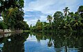
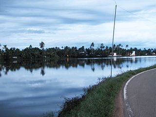
The Kerala backwaters are a network of brackish lagoons and canals lying parallel to the Arabian Sea of the Malabar coast of Kerala state in south-western India. It also includes interconnected lakes, rivers, and inlets, a labyrinthine system formed by more than 900 km (560 mi) of waterways, and sometimes compared to bayous. The network includes five large lakes linked by canals, both man made and natural, fed by 38 rivers, and extending virtually half the length of Kerala state. The backwaters were formed by the action of waves and shore currents creating low barrier islands across the mouths of the many rivers flowing down from the Western Ghats range. In the midst of this landscape there are a number of towns and cities, which serve as the starting and end points of backwater cruises. There are 34 backwaters in Kerala. Out of it, 27 are located either closer to Arabian Sea or parallel to the sea. The remaining 7 are inland navigation routes.

Kuttanad is a region covering the Alappuzha, Kottayam and Pathanamthitta Districts, in the state of Kerala, India, well known for its vast paddy fields and geographical peculiarities. The region has the lowest altitude in India, and is one of the few places in the world where farming is carried on around 1.2 to 3.0 metres below sea level. Kuttanad is historically important in the ancient history of South India and is the major rice producer in the state. Farmers of Kuttanad are famous for Biosaline Farming. The United Nations Food and Agriculture Organization (FAO) has declared the Kuttanad Farming System as a Globally Important Agricultural Heritage System (GIAHS) in 2013.
Vithura, also known as the Hill City Of Trivandrum, is located 36 km from Thiruvananthapuram capital of the Kerala state in India. Vithura is the culmination of the crossroads to many tourist, cultural, and religious centres. Surrounded by the Western Ghats (Sahyadris), Vithura is a tourist spot. The village has a good climate year-round. The Indian Institute of Science Education and Research, Thiruvananthapuram campus is situated here.

Alappuzha, also known as Alleppey, is a municipality in the Alappuzha district of Kerala, India. It is the district headquarters of the district, and is located about 130 km (80.8 mi) north of the state capital Thiruvananthapuram. As per the 2011 Indian census, Alappuzha has a population of 240,991 people, and a population density of 3,675/km2 (9,520/sq mi).

Kainakary is a village in Kuttanad Taluk in Alappuzha District of the Indian state of Kerala.
Edathua is a small village in Kuttanad, Alappuzha district, Kerala, India. It is located 12 km from Thiruvalla city center, National Highway 183 and the Thiruvalla railway station.

Nayarambalam is a suburb of Kochi city and coastal village on Vypin island in the state of Kerala, India.
Ramankary is a village in the Kuttanad region of India. It is 9 km away from Changanacherry town and 17 km from Alappuzha city. It is one of the villages in Alapuzha on the bank of the Manimala River with picturesque vast paddy fields.

Punnavely is a village in Thiruvalla Constituency situated on the border of Pathanamthitta and Kottayam districts of Kerala, India. Punnavely is a typical Central Tranvancore village with rubber tree plantations, paddy fields, pepper and other spices and lot of NRIs.
Mankombu or Moncombu is a village in the district of Alappuzha in the state of Kerala, India. Monkombu, part of the Kuttanad delta region popularly mentioned as 'Rice bowl of Kerala'; is one of the major paddy cultivation regions of the state. Its unique geography embodied by Vembanad lake, inter-linked Pambaa, Manimala and Achenkovil river systems, gives rise to islands, back waters, network of waterways and canals, below sea-level paddy fields and marsh. The farmers here have met the challenges of below sea-level cultivation over two centuries. Annual festivals, auspicious rites and religious events at Mankombu Bhagavathi Devi temple, St.Pius church and Pope John Paul Church are occasions for social communion, rejoicing and celebration. Once a prosperous hamlet of hundreds of households, Mankombu today is ravaged by climate change, pollution and dwindling population.
Neerattupuram is a place in Kuttanad, Alappuzha district, Kerala, India. It is a part of Thalavady Grama Panchayat, situated near the junction of Alappuzha, Pathanamthitta and Kottayam districts, at the confluence of Pamba and Manimala rivers.

Champakara, Kottayam, Kerala, India, is a village in Kottayam District, 18 kilometres (11 mi) away from Kottayam in India. The State highway from Kottayam to Punaloor passes through the town. The name derived from the Malayalam word Sampal kara, or Sampath kara, which means "the land of prosperity."

Champakulam is a village in Kerala, India. It is in Alappuzha district. Champakulam is part of Kuttanad, the rice bowl of Kerala, and is resplendent in green paddy fields, coconut groves and water fowl. Champakulam is an important tourist spot and is famous for the Champakulam Moolam Boat Race. The river Pampa flows through the village, splitting it into two. It is connected by road to Alappuzha, Changanassery and Edathua.
Mithrakary is a small village in Kerala, India. It is located in Muttar Panchayat in Kuttanadu Taluk. It is presumed that this region was a very big forest in ancient years, but later destroyed by a forest fire. It is still possible to see "kari" (coal) if we dig deep into the soil. So this place name end-up with Kari. This village was the property of a well-known Brahmin family named 'Mithra Madom' in early days. The Brahmin family name 'Mithra' and the concept of the land arise from 'Karies' joined to form the name of this village - 'Mithra' 'Kari'. Another and more reliable storey behind the name is that in ancient era, this village was under the control of 'Mithran' - the village ruler. From his name this village got its name.
Muttar is a village in upper Kuttanad, Alappuzha district of Kerala, India. It is located 10 km west of Thiruvalla on the Kidangara Neerattupuram road, surrounded by Thalavady, Neerettupuram, Kunnamkary, Chathamkary & Mithrakary.
Chengalam South is a small hamlet located in Thiruvarpu panchayath in Kottayam town of Kerala, India.
Kudassanad is a village near Pandalam in the State of Kerala in India. Geographically it is situated in the eastern ending of Alappuzha District and western part of Pathanamthitta District. The southern end of Kudassanad is on the verge of Kollam District. Part of Palamel Panchayat and Mavelikara Taluk, Kudassanad comes under the Mavelikara Parliamentary and Mavelikara Assembly Constituencies.
Puthukkary is a small village in Kuttanadu Taluk. It is located in Ramankary Panchayat. It is 2 km far from Mampuzhakkary, at AC Road and, 5 km far from Edathua at Thiruvalla-Ambalappuzha Road. It is believed that this region was a very big forest in ancient years but later destroyed by a forest fire. Still we can see "kari" if we dig deep into the soil. So this place's name ended up with Kari. Mampuzhakkary-Edathua Road Passing through Puthukkary, 2 kilometers to Mampuzhakary and 5.5 kilometers to Edathua. Major Christian church is St Xaviers Church, now under the Archdiocese of Changanassery. Nearby villages are Kalangara Mithrakary, Oorukkary, Thekke Puthukkary, Kalangara, Koduppunna, Mampuzhakary, Edathua etc. Most of the villagers here are farmers and mainly depend on Alappuzha and Changanacherry for their day-to-day life.
Kainady is a village located in Neelamperoor panchayat in Alappuzha district of Kerala, India.
Kuttoor is a village in Thiruvalla Taluk, Pathanamthitta district in the Indian state of Kerala.Kuttoor panchayathu which is under Thiruvalla assembly constituency and Pulikkizhu block panchayathu.