
Banana is a rural town and locality in the Shire of Banana, Queensland, Australia. In the 2021 census, the locality of Banana had a population of 348 people.

Baralaba is a rural town and locality in the Shire of Banana in central Queensland, Australia. In the 2021 census, the locality of Baralaba had a population of 324 people.

The Shire of Banana is a local government area located in the Capricorn region of Queensland, Australia, inland from the regional city of Gladstone. The shire was named after the first township in the region (Banana), which in turn was named after the burial site of a huge dun coloured bullock named 'Banana'. The council sits in the town of Biloela, which is the largest town in the Shire.

Dululu is a rural town and locality in the Shire of Banana, Queensland, Australia. In the 2021 census, the locality of Dululu had a population of 97 people.

Goovigen is a rural town and locality in the Shire of Banana, Queensland, Australia. In the 2021 census, the locality of Goovigen had a population of 349 people.

Wowan is a rural town and locality in the Shire of Banana, Queensland, Australia. In the 2021 census, the locality of Wowan had a population of 170 people.

Rannes is a rural town in the west of the locality of Goovigen in the Shire of Banana, Queensland, Australia.

Jambin is a rural town and locality in the Shire of Banana, Queensland, Australia. In the 2021 census, the locality of Jambin had a population of 207 people.
The Callide Valley railway line ran from Rannes to Lawgi in Queensland, Australia. The Callide Valley lies to the south-west of Rockhampton in Central Queensland.

The Dawson Valley Branch Railway was a railway line in Central Queensland, Australia. It branched from the Central Western railway line at Kabra in the Rockhampton Region and went via Mount Morgan to Theodore in the Shire of Banana. It opened in a series of sections between 1898 and 1927, and featured a rack railway section, one of only 3 such systems in Australia.
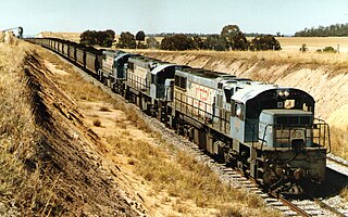
The Moura railway line is a railway in central Queensland, connecting several coal mines to the port of Gladstone. It connects the remnants of several lines that previously connected to Rockhampton, originally by a rack railway.

Alexandra is a suburb of Mackay in the Mackay Region, Queensland, Australia. In the 2021 census, Alexandra had a population of 189 people.

Pleystowe is a rural locality in the Mackay Region, Queensland, Australia. It is known for the former Pleystowe Sugar Mill used to crush sugar cane to produce raw sugar. In the 2021 census, Pleystowe had a population of 418 people.
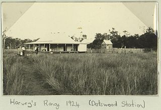
Dotswood is a rural locality in the Charters Towers Region, Queensland, Australia. In the 2021 census, Dotswood had a population of 83 people.

Callide is a rural town and locality in the Shire of Banana, Queensland, Australia. In the 2021 census, the locality of Callide had a population of 80 people.

Lawgi Dawes is a rural locality in the Shire of Banana, Queensland, Australia. It contains the neighbourhood of Lawgi, a former town.
Dixalea is a rural locality in the Shire of Banana, Queensland, Australia. In the 2021 census, Dixalea had a population of 102 people.
Alberta is a rural locality in the Shire of Banana, Queensland, Australia. In the 2021 census, Alberta had a population of 36 people.

Dumgree is a rural locality in the Shire of Banana, Queensland, Australia. In the 2021 census, Dumgree had a population of 63 people.

Kianga is a rural locality in the Shire of Banana, Queensland, Australia. In the 2021 census, Kianga had a population of 219 people.

