Lake Davis | |
---|---|
Coordinates: 39°52′8″N120°28′20″W / 39.86889°N 120.47222°W | |
Country | United States |
State | California |
County | Plumas |
Area | |
• Total | 5.382 sq mi (13.942 km2) |
• Land | 5.378 sq mi (13.930 km2) |
• Water | 0.004 sq mi (0.012 km2) 0.08% |
Elevation | 5,886 ft (1,794 m) |
Population (2010) | |
• Total | 45 |
• Density | 8.4/sq mi (3.2/km2) |
Time zone | UTC-8 (Pacific (PST)) |
• Summer (DST) | UTC-7 (PDT) |
ZIP code | 96137 |
Area code | 530 |
FIPS code | 06-39483 |
GNIS feature ID | 1853397 |
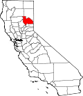
Lake Davis is a census-designated place (CDP) in Plumas County, California, United States, located on Lake Davis. The population was 45 at the 2010 census.
Lake Davis is located at 39°52′8″N120°28′20″W / 39.86889°N 120.47222°W (39.868841, -120.472214). [2]
According to the United States Census Bureau, the CDP has a total area of 5.4 square miles (14 km2), 99.92% of it land and 0.08% of it water.
Census | Pop. | Note | %± |
---|---|---|---|
U.S. Decennial Census [3] |
At the 2010 census Lake Davis had a population of 45. The population density was 8.4 people per square mile (3.2/km2). The racial makeup of Lake Davis was 45 (100.0%) White, 0 (0.0%) African American, 0 (0.0%) Native American, 0 (0.0%) Asian, 0 (0.0%) Pacific Islander, 0 (0.0%) from other races, and 0 (0.0%) from two or more races. Hispanic or Latino of any race were 2 people (4.4%). [4]
The whole population lived in households, no one lived in non-institutionalized group quarters and no one was institutionalized.
There were 23 households, 2 (8.7%) had children under the age of 18 living in them, 17 (73.9%) were opposite-sex married couples living together, 0 (0%) had a female householder with no husband present, 0 (0%) had a male householder with no wife present. There were 1 (4.3%) unmarried opposite-sex partnerships, and 0 (0%) same-sex married couples or partnerships. 5 households (21.7%) were one person and 3 (13.0%) had someone living alone who was 65 or older. The average household size was 1.96. There were 17 families (73.9% of households); the average family size was 2.24.
The age distribution was 4 people (8.9%) under the age of 18, 0 people (0%) aged 18 to 24, 5 people (11.1%) aged 25 to 44, 24 people (53.3%) aged 45 to 64, and 12 people (26.7%) who were 65 or older. The median age was 60.5 years. For every 100 females, there were 104.5 males. For every 100 females age 18 and over, there were 115.8 males.
There were 155 housing units at an average density of 28.8 per square mile, of the occupied units 23 (100%) were owner-occupied and 0 (0%) were rented. The homeowner vacancy rate was 0%; the rental vacancy rate was 0%. 45 people (100% of the population) lived in owner-occupied housing units and 0 people (0%) lived in rental housing units.
At the 2000 census there were 23 people, 10 households, and 9 families in the CDP. The population density was 3.7 people per square mile (1.4/km2). There were 99 housing units at an average density of 16.1 per square mile (6.2/km2). The racial makeup of the CDP was 95.65% White and 4.35% African American. Hispanic or Latino of any race were 8.70%. [5]
Of the 10 households none had children under the age of 18 living with them, 80.0% were married couples living together, and 10.0% were non-families. No households were one person and none had someone living alone who was 65 or older. The average household size was 2.30 and the average family size was 2.33.
The age distribution was 30.4% from 25 to 44, 39.1% from 45 to 64, and 30.4% 65 or older. The median age was 60 years. For every 100 females, there were 155.6 males. For every 100 females age 18 and over, there were 155.6 males.
The census-designated place is just downstream from the Grizzly Valley Dam, which impounds Lake Davis.
In the state legislature, Lake Davis is in the 1st Senate District , represented by Republican Brian Dahle, [6] and the 1st Assembly District , represented by Republican Megan Dahle. [7]
Federally, Lake Davis is in California's 1st congressional district , represented by Republican Doug LaMalfa. [8]
Shaver Lake is a census-designated place (CDP) in Fresno County, California, United States. The population was 634 at the 2010 census, down from 705 at the 2000 census. Shaver Lake is on the southwest end of the lake of the same name, 10 miles (16 km) east of New Auberry, at an elevation of 5,627 ft (1,715 m). The name honors C.B. Shaver, founder of the Fresno Flume and Irrigation Company that built the dam, creating the lake. The lake served as a mill pond for the Shaver Sawmill and the source for a flume that ran 65 miles (105 km) to Clovis. The original town of Shaver was buried under the lake when the Thomas A. Edison Company purchased and enlarged the lake in 1919.
Lake of the Pines is a census-designated place (CDP) and a gated residential community in Nevada County, California, United States. The population was 3,917 at the 2010 census.
Lake Wildwood is a census-designated place (CDP) in Nevada County, California, United States. The population was 4,991 at the 2010 census, up from 4,868 at the 2000 census.
Bucks Lake is a census-designated place (CDP) in Plumas County, California, United States. Bucks Lake is located on the south shore of the lake of the same name, 13 miles (20.9 km) west-southwest of Quincy. The population was 22 at the 2020 census, up from 10 at the 2010 census.
Iron Horse is a census-designated place (CDP) in Plumas County, California, United States. The population was 297 at the 2010 census, down from 321 at the 2000 census.
Keddie is a census-designated place in Plumas County, California, United States. The population was 66 at the 2010 census.
La Porte is a census-designated place (CDP) in Plumas County, California, United States. The population was 26 at the 2010 census, down from 43 at the 2000 census.
Lake Almanor Country Club is a census-designated place (CDP) in Plumas County, California, United States. The population was 419 at the 2010 census, down from 847 at the 2000 census. The ZIP code for the CDP is 96137.
Lake Almanor Peninsula is a census-designated place (CDP) in Plumas County, California, United States. The population was 356 at the 2010 census, up from 336 at the 2000 census.
Lake Almanor West is a census-designated place (CDP) in Plumas County, California, United States. The population was 270 at the 2010 census, down from 329 at the 2000 census.
Meadow Valley is a census-designated place (CDP) in Plumas County, California, United States. The population was 453 at the 2020 census, down from 464 at the 2010 census.
Plumas Eureka is a census-designated place (CDP) in Plumas County, California, United States. The population was 320 at the 2000 census.
Spring Garden is a census-designated place (CDP) in Plumas County, California, United States. The population was 16 at the 2010 census, down from 55 at the 2000 census.
Taylorsville is a census-designated place (CDP) in Plumas County, California, United States. The population was 150 at the 2010 census, down from 154 at the 2000 census. The annual Stone Ranch Reunion is held in Taylorsville.
Valley Ranch is a census-designated place in Plumas County, California, United States. The population was 109 at the 2010 census, up from 92 at the 2000 census.
Edgewood is a census-designated place (CDP) in Siskiyou County, California, United States. Its population is 72 as of the 2020 census, up from 43 from the 2010 census. Edgewood is located three miles north of the town of Weed.
Gazelle is a census-designated place (CDP) in Siskiyou County, California, United States. Its population is 95 as of the 2020 census, up from 70 from the 2010 census.
China Lake Acres is a census-designated place (CDP) in Kern County, California, United States. The population was 1,876 at the 2010 census, up from 1,761 at the 2000 census.
Robin Glen-Indiantown is a census-designated place (CDP) in Buena Vista Charter Township, Saginaw County in the U.S. state of Michigan. The CDP is used for statistical purposes and has no legal status as an incorporated municipality. The population was 1,158 at the 2000 census.
Victory Lakes is an unincorporated community and census-designated place (CDP) located within Monroe Township, in Gloucester County, in the U.S. state of New Jersey. As of the 2010 United States Census, the CDP's population was 2,111.