Lake George (town), New York

Last updated

Lake George
Downtown Lake George, NY.jpg
Downtown Lake George
Lake George New York.PNG
Location of Lake George in Warren County
USA New York location map.svg
Red pog.svg
Lake George
Location within the state of New York
Coordinates: 43°25′28″N73°42′55″W / 43.42444°N 73.71528°W / 43.42444; -73.71528
Country United States
State New York
County Warren
Area
[1]
  Total32.62 sq mi (84.48 km2)
  Land30.07 sq mi (77.88 km2)
  Water2.55 sq mi (6.60 km2)
Population
 (2020) [2]
  Total3,502
  Density110/sq mi (41/km2)
Time zone UTC-5 (Eastern (EST))
  Summer (DST) UTC-4 (EDT)
ZIP code
12845
Area code 518
Website lakegeorgetown.org

Lake George is a town in Warren County, New York, United States. The population was 3,502 at the 2020 census. [3] The town is named after the lake, Lake George. The town is part of the Glens Falls Metropolitan Statistical Area. [4]

Contents

History

The first European to visit the lake was Father Isaac Jogues in August 1642. [5] He was later captured by Mohawks, escaped, and returned home to France. In 1646, he was sent on a political mission to the Iroquois to propose a treaty of peace, and at that point dubbed the lake "Lac du Saint Sacrement" (Lake of the Blessed Sacrament). [5]

In 1755, the lake was renamed "Lake George" by General William Johnson, in honor of King George II. [5]

Lake George was also the site of Fort William Henry, named in honor of Prince William Henry, grandson of King George II, by General Johnson. The fort, its surrender to the Marquis de Montcalm after a six-day siege by the French and Indians, and the following massacre all in 1757 were used by James Fenimore Cooper as the background for his famous novel The Last of the Mohicans . The fort was reconstructed and opened to the public as a museum in 1953. [5]

The town was established in 1810 as the "Town of Caldwell" from parts of the nearby towns of Bolton, Queensbury, and Thurman, [6] and in 1962, the town changed its name to Lake George. [5]

The town is also home to Wiawaka, a historic retreat center that was founded in 1903 for female textile workers from Troy but operates as a nonprofit for everyone today.[ citation needed ]

The FORWARD shipwreck site (motor launch), Royal C. Peabody Estate, Wiawaka Bateaux Site, and Wiawaka Holiday House are listed on the National Register of Historic Places. The Land Tortoise (radeau) Shipwreck Site and Owl's Nest are National Historic Landmarks. [7] The Lake George Battlefield Park Historic District was listed in 2011.

Geography

According to the United States Census Bureau, the town has a total area of 32.7 square miles (85 km2), of which 30.2 square miles (78 km2) is land and 2.5 square miles (6.5 km2) (7.49%) is water. According to the Lake George Association, Lake George is 32 miles in length and a maximum of two miles in width. [8]

The Adirondack Northway passes through the town.

Demographics

Historical population
CensusPop.Note
1820 723
1830 79710.2%
1840 693−13.0%
1850 7528.5%
1860 1,07442.8%
1870 1,041−3.1%
1880 1,22317.5%
1890 1,37712.6%
1900 1,4656.4%
1910 1,4821.2%
1920 1,297−12.5%
1930 1,73033.4%
1940 1,467−15.2%
1950 1,62110.5%
1960 2,42949.8%
1970 2,80615.5%
1980 3,39421.0%
1990 3,211−5.4%
2000 3,57811.4%
2010 3,515−1.8%
2020 3,502−0.4%
U.S. Decennial Census [9] [10]
A row of motels in Lake George, 1973 ROW OF MOTELS AT LAKE GEORGE VILLAGE, NEW YORK, AND PLETHORA OF SIGNS CREATES A NON-RUSTIC SCENE IN THE ADIRONDACK... - NARA - 554550.jpg
A row of motels in Lake George, 1973

As of the census [2] of 2000, there were 3,578 people, 1,533 households, and 1,002 families residing in the town. The population density was 118.3 people per square mile (45.7 people/km2). There were 2,456 housing units at an average density of 81.2 per square mile (31.4/km2). The racial makeup of the town was 97.74% White, 0.53% Black or African American, 0.25% Native American, 0.59% Asian, 0.03% Pacific Islander, 0.17% from other races, and 0.70% from two or more races. Hispanic or Latino of any race were 0.92% of the population.

There were 1,533 households, out of which 27.2% had children under the age of 18 living with them, 50.8% were married couples living together, 9.8% had a female householder with no husband present, and 34.6% were non-families. 28.1% of all households were made up of individuals, and 9.8% had someone living alone who was 65 years of age or older. The average household size was 2.33 and the average family size was 2.84.

In the town, the population was spread out, with 21.7% under the age of 18, 6.8% from 18 to 24, 25.8% from 25 to 44, 30.8% from 45 to 64, and 14.9% who were 65 years of age or older. The median age was 42 years. For every 100 females, there were 103.5 males. For every 100 females age 18 and over, there were 100.1 males.

The median income for a household in the town was $42,125, and the median income for a family was $48,789. Males had a median income of $31,134 versus $22,375 for females. The per capita income for the town was $22,311. About 3.6% of families and 6.8% of the population were below the poverty line, including 7.2% of those under age 18 and 6.3% of those age 65 or over.

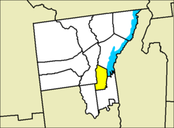
Communities and locations in the Town of Lake George

Related Research Articles

Colchester is a town in Delaware County, New York, United States. The population was 1,782 at the 2020 census. The town is in the southwestern part of the county.

Hamden is a town in Delaware County, New York, United States. The population was 1,137 at the 2020 census.

<span class="mw-page-title-main">Tompkins, New York</span> Town in Delaware County, New York, US

Tompkins is a town in Delaware County, New York, United States. The population was 1,290 at the 2020 census. The town is named after Daniel D. Tompkins, the fourth governor of New York and sixth vice president of the United States.

<span class="mw-page-title-main">Prattsville (town), New York</span> Town in New York, United States

Prattsville is a town in Greene County, New York, United States. The town is in the northwestern part of the county. As of the 2020 census, the population was 774.

<span class="mw-page-title-main">Petersburgh, New York</span> Town in New York, United States

Petersburgh is a town located in the northeast section of Rensselaer County, New York, United States. The population was 1,372 at the 2020 census. The town was named after an early settler named Peter Simmons.

<span class="mw-page-title-main">Charlton, New York</span> Town in New York, United States

Charlton is a town in Saratoga County, New York, United States. The population was 4,328 at the 2020 census. The town is named after a notable physician.

<span class="mw-page-title-main">Carlisle, New York</span> Town in New York, United States

Carlisle is a town in northern Schoharie County, New York, United States. The population was 1,768 at the 2020 census.

<span class="mw-page-title-main">Fulton, Schoharie County, New York</span> Town in Schoharie County, New York, US

Fulton is a town in Schoharie County, New York, United States. The population was 1,199 at the 2020 census. Within the town of Fulton are the hamlets of Breakabeen and Fultonham. The town is in the center of the county and is also one of the larger towns in the county. Fulton is west of Albany.

<span class="mw-page-title-main">Seward, New York</span> Town in New York, United States

Seward is a town in Schoharie County, New York, United States. The population was 1,583 at the 2020 census. The town is named after senator, governor, and secretary of state William H. Seward.

<span class="mw-page-title-main">Summit, New York</span> Town in New York, United States

Summit is a town in Schoharie County, New York, United States. The population was 1,072 at the time of the 2020 census. The name is derived from a peak that was thought to be the highest elevation in the county.

<span class="mw-page-title-main">Wright, New York</span> Town in New York, United States

Wright is a town in Schoharie County, New York, United States. The population was 1,516 at the 2020 census. The town was named after governor Silas Wright.

<span class="mw-page-title-main">Denning, New York</span> Town in New York, United States

Denning is an isolated town in Ulster County, New York, United States. The population was 493 at the 2020 census. The town is named after an early landowner, William Denning. Denning is located in the western part of the county, deep inside the Catskill Mountains. The location of the town in the Catskill State Park accounts in part for its low population.

<span class="mw-page-title-main">Olive, New York</span> Town in New York, United States

Olive is a town in Ulster County, New York, United States. The town is west of Kingston, New York, and is inside the Catskill Park. The population was 4,226 at the 2020 census.

<span class="mw-page-title-main">Johnsburg, New York</span> Town in New York, United States

Johnsburg is a town in the northwestern corner of Warren County, New York, United States. It is part of the Glens Falls Metropolitan Statistical Area. The town population was 2,143 at the 2020 census. The town is named after John Thurman, an early settler and founder. Johnsburg is the largest town in Warren County by area.

<span class="mw-page-title-main">Hartford, New York</span> Town in New York, United States

Hartford is a town centrally located in Washington County, New York, United States. It is part of the Glens Falls Metropolitan Statistical Area. The town population was 2,193 at the 2020 census.

<span class="mw-page-title-main">Walton (town), New York</span> Town in New York, United States

Walton is a town in Delaware County, New York, United States. The population was 5,270 at the 2020 census. The town is in the west-central part of the county and contains the village of Walton. The town claims to be the "Scarecrow Capital of the World."

Greenville is a hamlet and census-designated place (CDP) in the town of Greenville, in Greene County, New York, United States. The population of the CDP was 688 at the 2020 census, out of a total 3,741 people in the town as a whole.

Cape Vincent is a town in Jefferson County, New York, United States. The population was 2,765 at the 2020 census.

<span class="mw-page-title-main">Plattekill, New York</span> Place in New York, United States

Plattekill is a town in Ulster County, New York, United States. The population was 10,424 in 2020, a slight decrease from 10,499 at the 2010 census. The name is derived from a stream, the Platte Kill.

<span class="mw-page-title-main">Fort Edward, New York</span> Town in New York, United States

Fort Edward is a town and the county seat of Washington County, New York, United States. The population was 5,991 at the 2020 census. The municipal center complex is on U.S. Route 4 between the villages of Hudson Falls and Fort Edward. When construction of the complex was completed in 1994, most of the administrative offices were moved from the original county seat of Hudson Falls to this location. The town of Fort Edward is part of the Glens Falls Metropolitan Statistical Area.

References

  1. "2016 U.S. Gazetteer Files". United States Census Bureau. Retrieved July 5, 2017.
  2. 1 2 "U.S. Census website". United States Census Bureau . Retrieved January 31, 2008.
  3. US Census 2020 Report, Lake George town, New York https://www.census.gov/search-results.html?searchType=web&cssp=SERP&q=Lake%20George%20town,%20Warren%20County,%20New%20York
  4. "Metropolitan Areas and Components, 1999, with FIPS Codes". US Census Bureau. Retrieved July 7, 2009.
  5. 1 2 3 4 5 "History". Town of Lake George. Retrieved March 10, 2021.
  6. History of Warren County (1885), edited by H. P. Smith, "Chapter XXXII: History of the Town of Caldwell". rootsweb.com. Accessed July 17, 2015.
  7. "National Register Information System". National Register of Historic Places . National Park Service. March 13, 2009.
  8. "Home". lakegeorgeassociation.org.
  9. "Census of Population and Housing". Census.gov. Retrieved June 4, 2015.
  10. US Census 2020 Report, Lake George town, New York https://www.census.gov/search-results.html?searchType=web&cssp=SERP&q=Lake%20George%20town,%20Warren%20County,%20New%20York