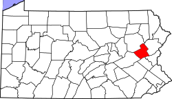
Lake Harmony, Pennsylvania

Last updated

Lake Harmony
USA Pennsylvania location map.svg
Red pog.svg
Lake Harmony
Location within the U.S. state of Pennsylvania
Usa edcp location map.svg
Red pog.svg
Lake Harmony
Lake Harmony (the United States)
Coordinates: 40°59′59″N75°42′29″W / 40.99972°N 75.70806°W / 40.99972; -75.70806
Country United States
State Pennsylvania
County Carbon
Township Kidder
Elevation
1,329 ft (405 m)
Population
 (2010)
718
Time zone UTC-5 (EST)
  Summer (DST) UTC-4 (EDT)
ZIP code
18624
Area code 570

Lake Harmony is an unincorporated community in Kidder Township, Carbon County, Pennsylvania, United States. The population was 718 at the 2010 census. It is served by ZIP Code 18624.

Contents

History

In 1913, Frederick Charles Brenckman wrote:

The region about Lake Harmony has in recent years become quite popular as a summer resort. Numerous cottages or bungalows have been erected, principally by people from Mauch Chunk and Allentown, while many, lured by the cool breezes and quietness of the retreat, spend a portion of the heated term of each year as campers on the shores of the lake. [1]

The Split Rock Lodge at Lake Harmony was originally a private retreat for the executives of the Lehigh Coal and Navigation Company, but much of the land was sold to developers. The lodge was destroyed by fire in 1970. A portion of the building survived the blaze, and it was rebuilt and sold to Village Square, Incorporated. [2] After several changes in ownership, current ownership since 2020 is held by Mexico-based Bel Air Collection Resorts & Spas, itself owned and operated by Thy Collection. Bel Air Collections promised numerous renovations throughout the resort, from room redesigns to refurbished fitness areas to bar and restaurant amenities. [3] A spokesman for the company stated in 2022 that Covid-19 delayed progress on the renovations. [4] Lawsuits in 2023 suggest that progress in some areas of renovations have ground to a halt or even regressed, with timeshare owners alleging false advertising practices by Bel Air. [5] [6] [7]

Geography

According to the U.S. Census Bureau, Lake Harmony has a total area of 16.9 square miles (43.9 km2), 16.5 square miles (42.7 km2) of which is land and 0.46 square miles (1.2 km2) of which is water. The community is located of the shores of the eponymous Lake Harmony. [8] It has a warm-summer humid continental climate (Dfb) and average monthly temperatures range from 22.2 °F in January to 68.0 °F in July. The hardiness zone is 5b.

Demographics

Historical population
CensusPop.Note
2000 439
2010 71863.6%

Lake Harmony is neither an incorporated area nor a census-designated place, all the data is for the ZIP code 18624. As of the census of 2010, there were 718 people, 359 households, and 203 families residing in the community. The population density was 43.5 people per square mile (6.6/km2). There were 1,594 housing units at an average density of 96.6 per square mile (37.3/km2). The racial makeup of thecommunity was 95.8% White, 1.7% African American, 0.1% Native American, 0.7% Asian, 1.0% from other races, and 0.7% from two or more races. Hispanic or Latino of any race were 3.1% of the population. [9]

Updated data suggests a decline in population; in 2016, there was an estimated population of 540 people, 359 occupied housing units out of 1,594, and 168 families. Population density is 45 people per square mile. The racial makeup of the community remains overwhelmingly white at 95.8%, 1.7% African American, 0.1% Native American, 0.7% Asian, 0% Native Hawaiian & Other Pacific Islander, 1% Other Race, and 0.7% Two of More Races. [10]

There were 359 households, out of which 14.8% had children under the age of 18 living with them, 46.8% were married couples living together, 5.6% had a female householder with no husband present, and 43.5% were non-families. Out of all the households, 7.5% had someone living alone who was 65 years of age or older. The average household size was 2.0 and the average family size was 2.61. 69.95 of the housing units were for seasonal, recreational, or occasional use. [9]

In the community, the population was spread out, with 14.4% under the age of 18, 4.7% from 19 to 24, 18.2% from 25 to 44, 37.4% from 45 to 64, and 25.3% who were 65 years of age or older. The median age was 52 years. The gender distribution was 52.9% male and 47.1% female. [9]

According to the American Community Survey in 2013, the median income for a household in the community was $61,563, and the median income for a family was $62,500. [9]

Related Research Articles

<span class="mw-page-title-main">Monroe County, Pennsylvania</span> County in Pennsylvania, United States

Monroe County is a county in the Commonwealth of Pennsylvania. As of the 2020 census, the population was 168,327. Its county seat is Stroudsburg. The county is part of the Northeast Pennsylvania region of the state.

<span class="mw-page-title-main">Caledonia Township, Alcona County, Michigan</span> Civil township in Michigan, United States

Caledonia Township is a civil township of Alcona County in the U.S. state of Michigan. The population was 1,032 at the 2020 census.

<span class="mw-page-title-main">Greenbush Township, Alcona County, Michigan</span> Civil township in Michigan, United States

Greenbush Township is a civil township of Alcona County in the U.S. state of Michigan. The population was 1,270 at the 2020 census. The population in 2021 is estimated to be 1,281.

Laketown Township is a civil township of Allegan County in the U.S. state of Michigan. The population was 5,928 at the 2020 census.

<span class="mw-page-title-main">Shorewood–Tower Hills–Harbert, Michigan</span> Census-designated place & unincorporated communities in Michigan, United States

Shorewood–Tower Hills–Harbert is a census-designated place (CDP) composed of several small unincorporated communities in Chikaming Township of Berrien County in the U.S. state of Michigan. The population was 1,249 at the 2020 census. The CDP is limited to Chikaming Township, although some of the communities extend into southern Lake Township. All of the communities are located either upon or just east of the dunes on the shore of Lake Michigan. Most of the communities lie west of Interstate 94, although the CDP includes a small area east of the freeway up to Sawyer, Michigan. The township is a popular resort destination.

<span class="mw-page-title-main">Indian River, Michigan</span> Census-designated place & unincorporated community in Michigan, United States

Indian River is an unincorporated community and census-designated place (CDP) in Cheboygan County in the U.S. state of Michigan. The population was 1,950 at the 2020 census. The CDP is located in Tuscarora Township between Burt Lake and Mullett Lake.

<span class="mw-page-title-main">Canadian Lakes, Michigan</span> Census-designated place in Michigan, United States

Canadian Lakes is an unincorporated community and census-designated place (CDP) in Mecosta County in the U.S. state of Michigan. The area is mostly within the southwest portion of Morton Township, southwest of Mecosta and east of Stanwood. As of the 2020 census, the CDP population was 3,202, up from 2,756 in 2010. The area defined by the CDP includes small portions in eastern Austin Township.

Merrill Township is a civil township of Newaygo County in the U.S. state of Michigan. The population was 741 at the 2020 census.

<span class="mw-page-title-main">Towamensing Township, Pennsylvania</span> Place in Pennsylvania, United States

Towamensing Township is a lightly populated rural township in eastern Carbon County, Pennsylvania. It is part of Northeastern Pennsylvania.

<span class="mw-page-title-main">Mount Pocono, Pennsylvania</span> Place in Pennsylvania, United States

Mount Pocono is a borough in Monroe County, Pennsylvania. The borough serves as a local highway nexus, and sees a lot of tourist traffic making use of resources in the region. As of the 2020 census, the borough population was 3,083 residents.

<span class="mw-page-title-main">Pocono Pines, Pennsylvania</span> Census-designated place in Pennsylvania, United States

Pocono Pines is a census-designated place (CDP) in Monroe County, Pennsylvania. The population in the 2020 United States Census was 2,007, an increase over the 1,409 population at the 2010 census.

<span class="mw-page-title-main">Tobyhanna Township, Pennsylvania</span> Place in Pennsylvania, United States

Tobyhanna Township is a township in Monroe County, Pennsylvania, United States. The population was 8,290 at the 2020 census. Tobyhanna Township has Tobyhanna Elementary Center and Locust Lake Village.

<span class="mw-page-title-main">Brookdale, California</span> Census-designated place in California, United States

Brookdale is a census-designated place (CDP) in Santa Cruz County, California. Brookdale sits at an elevation of 405 feet (123 m). It is located in the San Lorenzo Valley between Boulder Creek and Ben Lomond on Highway 9. The 2010 United States census reported Brookdale's population was 1,991.

<span class="mw-page-title-main">Fish Camp, California</span> Census-designated place in California, United States

Fish Camp is a census-designated place in Mariposa County, California, United States. It is located 18 miles (29 km) east of Mariposa, at an elevation of 5,062 feet (1,543 m). The population was 49 at the 2020 census. The ZIP Code is 93623, and the community is inside area code 559.

Sugarloaf is an unincorporated community residential area less than a mile south of Big Bear City and 8 miles from the eastern tip of Big Bear Lake in the San Bernardino Mountains of San Bernardino County, California. The area is primarily residential with a convenience store and a post office located at the center of the community. The residential area is set at an elevation of 7,096 feet at its center, whereas its extreme northern border is 6,998 feet above sea level and the southern tip sits at 7,218 feet above sea level. There is no municipal organization for the area, and all fire, water, and police service is provided by San Bernardino County. The ZIP code for the community is 92386, the area code 909, and the population is 1,816. Big Bear High School is located in the northern part of the community.

Woodloch Pines is an all-inclusive resort located in Hawley, Pennsylvania on Lake Teedyuskung in the northeast Pocono Mountains Lake Region. The nearest large city is Scranton, which is 40 miles away. The resort has been owned by the Kiesendahl Family since 1958 and is open all year round. In recent years, Woodloch has expanded to include Woodloch Springs, a championship golf course and housing community, and The Lodge at Woodloch, a destination spa. Woodloch Pines, Woodloch Springs, and The lodge at Woodloch are all separate resorts.

Tahoma is a census-designated place in Placer and El Dorado counties, California, United States. Tahoma is located along Lake Tahoe 2 miles (3.2 km) southeast of Homewood. Tahoma has a population of 1,191.

Crystal Township is a civil township of Montcalm County in the U.S. state of Michigan. As of the 2020 census, the township population was 2,619.

Albrightsville is an unincorporated community and census-designated place which is located in Kidder and Penn Forest townships, Carbon County, Pennsylvania, United States. It is part of Northeastern Pennsylvania.

<span class="mw-page-title-main">Pocono Springs, Pennsylvania</span> Place in Pennsylvania, United States

Pocono Springs is a private community and census-designated place (CDP) in Lehigh and Sterling Townships in Wayne County, Pennsylvania, United States. The CDP's population was 926 at the time of the 2010 United States Census.

References

  1. Brenckman, Frederick Charles (1913). History of Carbon County, Pennsylvania: Also Containing a Separate Account of the Several Boroughs and Townships in the County, with Biographical Sketches. J. J. Nungesser. p.  213. lake harmony.
  2. "Getaway Weekends: Split Rock Lodge". New York . July 30, 1979. Retrieved August 17, 2018.
  3. "Split Rock Resort Under New Ownership Joining Bel Air Collection Resorts & Spas". Jim Thorpe Current. The Current. Retrieved February 23, 2024.
  4. Eustice, Amanda. "Newly renovated rooms at Split Rock Lodge". www.wnep.com. WNEP. Retrieved February 23, 2024.
  5. "Lawsuit: Poconos-area resort downgraded accommodations, engaged in deceptive business practices". WFMZ 69 News. WFMZ. Retrieved February 23, 2024.
  6. Cherkauskas, Emily. "Lawsuit filed against Poconos resort for alleged downgraded accommodations". Fox 56 Wolf. Fox. Retrieved February 23, 2024.
  7. "AG Henry Files Suit Against Poconos-Area Resort Which Downgraded Accommodations, Charged Excessive Fees for Timeshare Owners". www.attorneygeneral.gov. Pennsylvania Attorney General. Retrieved February 23, 2024.
  8. "18624 zip code Lake Harmony". BrainyZip. Retrieved August 17, 2015.
  9. 1 2 3 4 "U.S. Census website". United States Census Bureau . Retrieved August 17, 2015.
  10. "Cities in ZIP code 18624". United States Zip Codes. Retrieved February 23, 2024.