This article needs additional citations for verification .(September 2007) |
Lead Hill, Arkansas | |
---|---|
Coordinates: 36°24′49″N92°54′24″W / 36.41361°N 92.90667°W | |
Country | United States |
State | Arkansas |
County | Boone |
Government | |
• Type | Council government |
Area | |
• Total | 0.66 sq mi (1.72 km2) |
• Land | 0.58 sq mi (1.50 km2) |
• Water | 0.09 sq mi (0.22 km2) |
Elevation | 699 ft (213 m) |
Population (2020) | |
• Total | 274 |
• Density | 474.05/sq mi (182.99/km2) |
Time zone | UTC-6 (Central (CST)) |
• Summer (DST) | UTC-5 (CDT) |
ZIP codes | 72630, 72644 |
Area code | 870 |
FIPS code | 05-39040 |
GNIS feature ID | 2405994 [2] |
Website | leadhill.net |
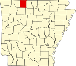
Lead Hill is a town in Boone County, Arkansas, United States. The population was 271 at the 2010 census. It is part of the Harrison Micropolitan Statistical Area.
Lead Hill was named from valuable deposits of lead in the vicinity. [3]
The unfinished ruins of the Ozark Medieval Fortress, built between 2009-2012, are located in Lead Hill.
According to the United States Census Bureau, the town has a total area of 0.5 square miles (1.3 km2), of which 0.5 square miles (1.3 km2) is land and 0.1 square miles (0.26 km2) (12.96%) is water.
Census | Pop. | Note | %± |
---|---|---|---|
1880 | 253 | — | |
1890 | 333 | 31.6% | |
1920 | 218 | — | |
1930 | 268 | 22.9% | |
1940 | 194 | −27.6% | |
1950 | 110 | −43.3% | |
1960 | 102 | −7.3% | |
1970 | 143 | 40.2% | |
1980 | 247 | 72.7% | |
1990 | 283 | 14.6% | |
2000 | 287 | 1.4% | |
2010 | 271 | −5.6% | |
2020 | 274 | 1.1% | |
U.S. Decennial Census [4] |
As of the census [5] of 2000, there were 287 people, 126 households, and 86 families residing in the town. The population density was 605.2 inhabitants per square mile (233.7/km2). There were 144 housing units at an average density of 303.7 per square mile (117.3/km2). The racial makeup of the town was 96.86% White, 0.35% Asian, and 2.79% from two or more races. 0.35% of the population were Hispanic or Latino of any race.
There were 126 households, out of which 28.6% had children under the age of 18 living with them, 57.1% were married couples living together, 10.3% had a female householder with no husband present, and 31.7% were non-families. 27.8% of all households were made up of individuals, and 18.3% had someone living alone who was 65 years of age or older. The average household size was 2.28 and the average family size was 2.78.
In the town, the population was spread out, with 23.7% under the age of 18, 3.8% from 18 to 24, 24.7% from 25 to 44, 22.0% from 45 to 64, and 25.8% who were 65 years of age or older. The median age was 43 years. For every 100 females, there were 90.1 males. For every 100 females age 18 and over, there were 79.5 males.
The median income for a household in the town was $30,625, and the median income for a family was $32,500. Males had a median income of $24,375 versus $18,864 for females. The per capita income for the town was $13,051. About 9.3% of families and 15.7% of the population were below the poverty line, including 23.4% of those under the age of eighteen and 12.8% of those 65 or over.
Lead Hill, along with South Lead Hill and Diamond City, is within the Lead Hill School District, which leads to graduation from Lead Hill High School. [6]
Due to its elevation, northerly latitude, and surrounding topography, Lead Hill often experiences the lowest minimum temperatures in the state during Arkansas's cooler months.[ citation needed ] This distinction, though, is often shared with the small Buffalo River hamlet of Gilbert.
Climate data for Lead Hill, Arkansas (1991–2020 normals, extremes 1927–present) | |||||||||||||
---|---|---|---|---|---|---|---|---|---|---|---|---|---|
Month | Jan | Feb | Mar | Apr | May | Jun | Jul | Aug | Sep | Oct | Nov | Dec | Year |
Record high °F (°C) | 83 (28) | 88 (31) | 95 (35) | 94 (34) | 102 (39) | 107 (42) | 115 (46) | 116 (47) | 110 (43) | 101 (38) | 87 (31) | 84 (29) | 116 (47) |
Mean maximum °F (°C) | 69.6 (20.9) | 72.7 (22.6) | 80.2 (26.8) | 84.0 (28.9) | 88.1 (31.2) | 93.1 (33.9) | 97.5 (36.4) | 98.0 (36.7) | 93.6 (34.2) | 86.1 (30.1) | 76.4 (24.7) | 70.1 (21.2) | 99.6 (37.6) |
Mean daily maximum °F (°C) | 44.5 (6.9) | 49.1 (9.5) | 58.3 (14.6) | 67.6 (19.8) | 74.9 (23.8) | 83.4 (28.6) | 87.8 (31.0) | 87.4 (30.8) | 80.5 (26.9) | 69.7 (20.9) | 57.5 (14.2) | 47.2 (8.4) | 67.3 (19.6) |
Daily mean °F (°C) | 33.7 (0.9) | 37.5 (3.1) | 46.3 (7.9) | 55.5 (13.1) | 64.3 (17.9) | 73.1 (22.8) | 77.4 (25.2) | 76.2 (24.6) | 68.7 (20.4) | 57.3 (14.1) | 46.1 (7.8) | 36.8 (2.7) | 56.1 (13.4) |
Mean daily minimum °F (°C) | 22.9 (−5.1) | 25.9 (−3.4) | 34.2 (1.2) | 43.3 (6.3) | 53.6 (12.0) | 62.8 (17.1) | 66.9 (19.4) | 65.0 (18.3) | 56.9 (13.8) | 45.0 (7.2) | 34.7 (1.5) | 26.4 (−3.1) | 44.8 (7.1) |
Mean minimum °F (°C) | 4.4 (−15.3) | 8.0 (−13.3) | 15.6 (−9.1) | 26.4 (−3.1) | 37.1 (2.8) | 50.8 (10.4) | 56.5 (13.6) | 53.0 (11.7) | 40.8 (4.9) | 27.3 (−2.6) | 18.0 (−7.8) | 10.8 (−11.8) | 1.0 (−17.2) |
Record low °F (°C) | −28 (−33) | −21 (−29) | −14 (−26) | 12 (−11) | 28 (−2) | 39 (4) | 42 (6) | 42 (6) | 28 (−2) | 14 (−10) | 4 (−16) | −12 (−24) | −28 (−33) |
Average precipitation inches (mm) | 2.89 (73) | 2.75 (70) | 4.66 (118) | 5.18 (132) | 5.11 (130) | 3.85 (98) | 4.19 (106) | 3.23 (82) | 4.09 (104) | 3.97 (101) | 4.26 (108) | 3.24 (82) | 47.42 (1,204) |
Average snowfall inches (cm) | 2.6 (6.6) | 2.3 (5.8) | 2.1 (5.3) | 0.0 (0.0) | 0.0 (0.0) | 0.0 (0.0) | 0.0 (0.0) | 0.0 (0.0) | 0.0 (0.0) | 0.0 (0.0) | 0.1 (0.25) | 1.1 (2.8) | 8.2 (21) |
Average precipitation days (≥ 0.01 in) | 7.5 | 7.0 | 10.2 | 9.4 | 11.3 | 9.1 | 8.4 | 8.3 | 7.3 | 8.0 | 8.3 | 7.7 | 102.5 |
Average snowy days (≥ 0.1 in) | 1.6 | 1.0 | 0.6 | 0.0 | 0.0 | 0.0 | 0.0 | 0.0 | 0.0 | 0.0 | 0.1 | 0.4 | 3.7 |
Source: NOAA [7] [8] |
Lead Hill is located near Branson, Missouri and Diamond City.
Marion County is located in the Ozark Mountains in the U.S. state of Arkansas. The county is named for Francis Marion, the famous "Swamp Fox" of the Revolutionary War. Created as Arkansas's 35th county in 1836, Marion County is home to one incorporated town and four incorporated cities, including Yellville, the county seat. The county is also the site of numerous unincorporated communities and ghost towns. The county included part of what is now Searcy County, Arkansas, with many opposing to dividing them, which helped fueled the bloody Tutt-Everett War between 1844 and 1850.
Johnson County is a county located in the U.S. state of Arkansas. As of the 2020 census, the population was 25,749. The county seat is Clarksville. Johnson County is Arkansas's 30th county, formed on November 16, 1833, from a portion of Pope County and named for Benjamin Johnson, a Territorial Judge. It is an alcohol prohibition or dry county.
Fulton County is a county located in the U.S. state of Arkansas. As of the 2020 census, the population was 12,075. The county seat is Salem. Fulton County was formed on December 21, 1842, and named for William Fulton, the last governor of the Arkansas Territory. It is an alcohol prohibition or dry county.
Boone County is located in the U.S. state of Arkansas, along the Missouri border. As of the 2020 census, the population was 37,373. The county seat is Harrison. It is Arkansas's 62nd county, formed on April 9, 1869.
Gateway is a town in Benton County, Arkansas, United States. The population was 436 at the 2020 census, up from 405 in 2010. It is part of the Northwest Arkansas region. The town's name reflects its situation as the "gateway" to and from Arkansas.
Bergman is a town in Boone County, Arkansas, United States. The population was 439 at the 2010 census. It is part of the Harrison Micropolitan Statistical Area.
Diamond City is a city in northeast Boone County, Arkansas, United States. The population was 782 at the 2010 census. It is part of the Harrison Micropolitan Statistical Area.
Everton is a town in Boone County, Arkansas, United States. The population was 133 at the 2010 census. It is part of the Harrison Micropolitan Statistical Area.
Omaha is a town in Boone County, Arkansas, United States. As of the 2020 census the population stood at 128. It is a rural community located approximately 10 miles from Branson, Missouri and 15 miles from Harrison. The town is part of the Harrison Micropolitan Statistical Area.
South Lead Hill is a town in Boone County, Arkansas, United States. The population was 102 at the 2010 census. It is part of the Harrison Micropolitan Statistical Area.
Zinc is a town near the east-central edge of Boone County, Arkansas, United States. The population was 92 at the 2020 census. It is part of the Harrison Micropolitan Statistical Area. A chapter of the Ku Klux Klan operates in Zinc.
Coal Hill is a city in Johnson County, Arkansas, United States. The population was 1,012 at the 2010 census.
Smithville is a town in Lawrence County, Arkansas, United States. The population was 78 at the 2010 census.
St. Paul is a town in Madison County, Arkansas, United States. The population was 111 at the 2020 census. It is on the edge of the Northwest Arkansas region.
Pyatt is a town in western Marion County, Arkansas, United States. The population was 181 at the 2020 census, down from 221 in 2010.
Pindall is a town in Searcy County, Arkansas, United States. The population was 112 at the 2010 census. The town is said to be named for Governor Xenophon Overton Pindall.
Greenland is a city in Washington County, Arkansas, United States. The population is 1,213 as of the 2020 census. The community is located in the Boston Mountains, within the Ozark Mountains.
Winslow is a city in southern Washington County, Arkansas, United States. The population was 365 as of the 2020 census. It is part of the Northwest Arkansas region.
Sheldahl is a city in Polk, Boone, and Story counties in the U.S. state of Iowa. The population was 297 at the time of the 2020 census.
Ozark is a city in and the county seat of Christian County, Missouri. Its population was 21,284 as of the 2020 census. Ozark is also the third largest city in the Springfield, Missouri Metropolitan Area, and is centered along a business loop of U.S. Route 65, where it intersects with Missouri Route 14.