List
The Western Australian State Register of Heritage Places, as of 2023 [update] , lists the following 51 state registered places within the Shire of Broome:
| Place name | Place # | Street number | Street name | Suburb or town | Co-ordinates | Notes & former names | Photo |
|---|---|---|---|---|---|---|---|
| Matso's Store & Captain Gregory's House | 290 | 29 | Hamersley Street | Broome | 17°57′43″S122°14′26″E / 17.961946°S 122.24066°E | Union Bank (former), Streeter's No.2 Store, Monsoon Gallery |  |
| Chinatown Conservation Area | 291 | Frederick/Chapple/Short Streets | Broome | 17°57′08″S122°14′39″E / 17.952289°S 122.244173°E | Includes Aboriginal Site - Undanda |  | |
| Uniting Church, Broome | 292 | 11 | Anne Street | Broome | 17°57′44″S122°14′12″E / 17.962303°S 122.236591°E | Brady Memorial Hall | |
| Sun Picture Gardens | 293 | 8 | Carnarvon Street | Broome | 17°57′12″S122°14′35″E / 17.95344°S 122.24307°E | Sun Picture Theatre, Dry Goods Store |  |
| Old Police Lockup & Boab Tree | 294 | 22 | Carnarvon Street | Broome | 17°57′22″S122°14′33″E / 17.955974°S 122.242515°E | Pilgrim Music | |
| Roebuck Bay Hotel | 295 | 30 | Dampier Terrace | Broome | 17°57′18″S122°14′39″E / 17.954864°S 122.244247°E | The 'Roey' |  |
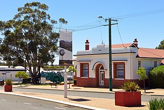
| Broome Court House | 296 | 8 | Hamersley Street | Broome | 17°57′25″S122°14′25″E / 17.95695°S 122.24033°E | Public Works Department, Cable Station, Cable House |  |
| Anglican Church of the Annunciation | 297 | 21 | Hamersley Street | Broome | 17°57′37″S122°14′27″E / 17.9604°S 122.2409°E | Pro Cathedral of the Annunciation, The Little White Church |  |
| Broome Bowling Club | 298 | 78 & 80 | Herbert Street | Broome | 17°57′49″S122°13′59″E / 17.963637°S 122.233136°E | Broome Coastal Wireless Station, OTC Building, AWA Communications staff quarters | |
| Pa Norman's House, Broome | 299 | 47 | Walcott Street | Broome | 17°57′47″S122°14′08″E / 17.96315°S 122.235656°E | Pa (Captain Hughes) Norman's Residence (former) | |
| Kennedy's Store | 300 | 9 | Napier Terrace | Broome | 17°57′21″S122°14′37″E / 17.955897°S 122.243482°E | Archie Martins | |
| Broome Cemetery - Japanese/Chinese/Muslim Section | 301 | Port Drive | Broome | 17°57′29″S122°13′23″E / 17.957994°S 122.22302°E |  | ||
| Broome Pioneer Cemetery | 302 | 87 | Robinson Street | Broome | 17°58′12″S122°14′11″E / 17.970068°S 122.236379°E | Seafarer's Cemetery, Seamen's Cemetery | |
| Streeter & Male Group of Stores | 304 | 4 | Short Street | Broome | 17°58′06″S122°14′12″E / 17.968297°S 122.236536°E |  | |
| Wallal Downs Station Group | 305 | 56 | Great Northern Highway | Eighty Mile Beach | 19°46′47″S120°38′28″E / 19.779652°S 120.641031°E | ||
| Lombadina Mission | 690 | Lombadina | Dampier Peninsula | 16°30′56″S122°53′34″E / 16.515678°S 122.892842°E | |||
| Hanoe's Cottage | 2668 | 6 | Carnarvon Street entry Short Street | Broome | 17°57′12″S122°14′35″E / 17.953211°S 122.242923°E |  | |
| Dampier Memorial | 2669 | 1 | Anne Street | Broome | 17°57′47″S122°14′20″E / 17.963058°S 122.23884°E | ||
| McDaniel Homestead | 2910 | 22 | Weld Street | Broome | 17°57′29″S122°14′20″E / 17.958138°S 122.238937°E | Blick House | |
| Maurice Lyon's House | 2913 | 17 | Anne Street | Broome | 17°57′44″S122°14′09″E / 17.962171°S 122.235843°E | ||
| Broome War Memorial, Bedford Memorial Park | 3593 | bounded by | Weld, Anne & Hamersley Streets | Broome | 17°57′47″S122°14′20″E / 17.962964°S 122.23886°E | ||
| Beagle Bay Mission Church | 3630 | Beagle Bay | Dampier Peninsula | 16°58′51″S122°39′58″E / 16.980750°S 122.666051°E | Sacred Heart Church | ||
| Streeter's Jetty | 4553 | 1 | Dampier Terrace | Broome | 17°57′12″S122°14′44″E / 17.95338°S 122.245526°E | Streeter and Male Jetty |  |
| Cottage | 4848 | 3 | Carnarvon Street | Broome | [?] | Demolished 29 December 2004 | |
| Kinney's Store | 4850 | 25 | Carnarvon Street | Broome | 17°57′14″S122°14′38″E / 17.953948°S 122.243765°E | Ellie's Store |  |
| Morgan's Camp | 4851 | 622, 16, 18 | Chapple Street | Broome | 17°56′59″S122°14′39″E / 17.949739°S 122.244056°E | Pearler's Camp | |
| Broome Pearls, Pearl Shop and Warehouse | 4853 | 29 | Dampier Terrace | Broome | 17°57′18″S122°14′41″E / 17.954864°S 122.24477°E | ||
| House, 57 Dampier Terrace | 4854 | 44 | Dampier Terrace | Broome | 17°57′23″S122°14′38″E / 17.956275°S 122.24393°E | Goode Durrant & Murray Showroom, Old Divers' Quarters, Old Pearlers' House | |
| Bourne & Inglis Store (former) | 4858 | 30 | Hamersley Street | Broome | 17°57′51″S122°14′15″E / 17.964171°S 122.237525°E | Paspaley Pearls Storage |  |
| Flying Boat Wreckage Site | 4859 | Roebuck Bay | Broome | 17°59′05″S122°14′47″E / 17.984713°S 122.24652°E | Catalina Wrecks | ||
| Sailmakers' Shed (former), Broome | 5250 | 71 | Robinson Street | Broome | 17°58′06″S122°14′12″E / 17.968297°S 122.236536°E | HMAS Broome - Naval Cadets Training Unit, PWD Storage, Water Corp Depot |  |
| St John of God Convent (former), Broome | 5307 | 11 | Barker Street | Broome | 17°57′32″S122°14′18″E / 17.958961°S 122.238412°E | Centacare |  |
| Community Health Services | 5368 | 12 | Anne Street | Broome | 17°57′41″S122°14′10″E / 17.961461°S 122.236079°E | Broome Hospital Nurses' Quarters, Commonwealth Health Laboratory | |
| Cape Leveque Lighthouse | 7198 | L 100 & 3001 | Broome-Cape Leveque Road | Dampier Peninsula | 16°23′41″S122°55′41″E / 16.3947°S 122.92797°E |  | |
| Male Sheds and Jetty | 8782 | 1 | Dampier Terrace | Broome | 17°57′04″S122°14′43″E / 17.951134°S 122.245391°E | Male Boat Sheds and Jetty | |
| Napier Terrace Cottages | 14007 | 3 | Napier Terrace | Broome | 17°57′21″S122°14′38″E / 17.955939°S 122.243888°E | Joybelle's Ladies Wear | |
| Broome Primary School Music Room | 15730 | 38 | Weld Street | Broome | 17°57′38″S122°14′17″E / 17.960656°S 122.238018°E | Broome Special School, Broome Junior High School | |
| Bob's Shoe Store | 15876 | 2b/30 | Carnarvon Street | Broome | [?] | formerly part of T.B. Ellies' store | |
| Anastasia's Pearl Gallery | 15877 | Carnarvon Street | Broome | [?] | formerley part of T.B.Ellies stores | ||
| Ah Ming's Store & Residence (former) | 15878 | 14 | Carnarvon Street | Broome | 17°57′14″S122°14′35″E / 17.953992°S 122.242968°E | Mr Kwok Cheung Yee, Dampier's Chest |  |
| Old Tang Wei Cafe & Residence | 15879 | 16 | Carnarvon Street | Broome | 17°57′15″S122°14′35″E / 17.954171°S 122.242933°E | ||
| Tack's Store (former) | 15880 | 12 | Carnarvon Street | Broome | 17°57′12″S122°14′44″E / 17.95338°S 122.245526°E | Terri's Travel |  |
| Shekki Shed Gallery | 15881 | 10 | Carnarvon Street | Broome | 17°57′13″S122°14′35″E / 17.953612°S 122.243153°E |  | |
| Offices | 15882 | 58 | Carnarvon Street | Broome | [?] | ||
| Offices | 16828 | 41 | Carnarvon Street | Broome | 17°57′22″S122°14′35″E / 17.956158°S 122.243083°E | ||
| Commemoratives | 16848 | 15 & 27 | Dampier Terrace | Broome | 17°57′16″S122°14′36″E / 17.954345°S 122.243337°E |  | |
| Shiba Lane (site) | 16849 | Napier Terrace | Broome | 17°57′22″S122°14′36″E / 17.956002°S 122.243392°E | Sheba Lane Cafe |  | |
| Blooms Cafe Restaurant | 16877 | 12 | Carnarvon Street | Broome | 17°57′14″S122°14′35″E / 17.953769°S 122.243011°E | ||
| Lyons Tate Office | 16878 | 10 | Carnarvon Street | Broome | 17°57′13″S122°14′35″E / 17.953702°S 122.243136°E | Akim's Bakery (former) |  |
| Bull Pen Shelter Shed and Archaeological Deposits | 19855 | 13 | Hamersley Street | Broome | 17°57′29″S122°14′28″E / 17.958142°S 122.241244°E | Bull Pen (Broome Prison), Broome Gaol, Native Cell, Broome Regional Prison | |
| Sheba Lane Cafe | 23977 | 5 | Napier Terrace | Broome | 17°57′21″S122°14′38″E / 17.955866°S 122.243852°E | Annelies Restaurant, Ibasco's hairdresser, Castaways |