List
The Western Australian State Register of Heritage Places, as of 2024 [update] , lists the following 15 state registered places within the Shire of Merredin:
| Place name | Place # | Street number | Street name | Suburb or town | Co-ordinates | Notes & former names | Photo |
|---|---|---|---|---|---|---|---|
| No. 4 Steam Pumping Station | 1564 | Great Eastern Highway | Merredin | 31°29′29″S118°14′33″E / 31.491410°S 118.242473°E | Part of the Goldfields Water Supply Scheme precinct (16610) |  | |
| Merredin Post Office Residence | 1566 | Bates Street | Merredin | 31°28′54″S118°16′42″E / 31.481699°S 118.278462°E |  | ||
| Merredin Fire Station Complex | 1567 | 28 | Bates Street | Merredin | 31°28′50″S118°16′42″E / 31.480508°S 118.278261°E |  | |
| Cummins Theatre | 1574 | 31 | Bates Street | Merredin | 31°28′48″S118°16′46″E / 31.480088°S 118.279412°E |  | |
| Road Board Office (former) | 1576 | Mitchell Street | Merredin | 31°28′50″S118°16′47″E / 31.480501°S 118.279631°E | Merredin Town Hall, Merredin Clock Tower Building |  | |
| Merredin Railway Station Group | 1577 | Lot 1503 | Todd Street | Merredin | 31°28′59″S118°16′41″E / 31.483011°S 118.27802°E | Merredin Railway Station Museum, Old Railway Station |  |
| Merredin Post Office | 1578 | Corner | Barrack & Bates Street | Merredin | 31°28′55″S118°16′42″E / 31.481919°S 118.278385°E |  | |
| Merredin Railway Water Tank | 3641 | Great Eastern Highway | Merredin | 31°29′00″S118°16′46″E / 31.483347°S 118.279513°E | Water Tower |  | |
| Merredin Post Office Group | 4035 | Corner | Barrack & Bates Street | Merredin | 31°28′55″S118°16′42″E / 31.481919°S 118.278385°E | Post Office, Post Office Residence (former), Telephone Line Equipment (Land Line Ex) Building |  |
| Merredin State Farm Manager's House (former) | 9080 | Great Eastern Highway | Merredin | 31°30′08″S118°12′52″E / 31.502185°S 118.214487°E | Merredin Research Station, Manager's House, Nangeenan Research Station | ||
| Agricultural Bank (former), Merredin | 13491 | 33 | Bates Street | Merredin | 31°28′48″S118°16′44″E / 31.479950°S 118.278926°E | Homeswest Office |  |
| 2/1 Australian General Hospital (ruins), Merredin | 13516 | Lot 1450 | Mackenzie Crescent | Merredin | 31°28′30″S118°17′48″E / 31.474997°S 118.296596°E | 2/1 AGH; Army Hospital, Merredin, First Australian General Hospital Site |  |
| Railway Dam, Merredin | 13523 | Gravel Track, continuation of Benson Street | Merredin | 31°28′13″S118°17′34″E / 31.470293°S 118.292756°E | Durdgutling, Durdgutting, Merredin Peak Dam (Well No.8), Quarries, Wall | ||
| Railway Housing Precinct, Merredin | 15750 | Kitchener Road | Merredin | 31°29′02″S118°16′27″E / 31.483876°S 118.274203°E | |||
| Goldfields Water Supply Scheme | 16610 | Listed under the Coolgardie, Cunderdin, Kellerberrin, Kalgoorlie–Boulder, Merredin, Mundaring, Northam, Tammin and Yilgarn State Heritage lists | Stretches from Mundaring Weir in Perth to the Eastern Goldfields, particularly Coolgardie and Kalgoorlie | 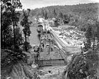 |