List of State Register of Heritage Places in the Shire of Augusta-Margaret River

Last updated

Map all coordinates using: OpenStreetMap  
Download coordinates as: KML

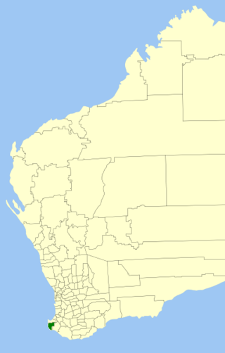
The State Register of Heritage Places is maintained by the Heritage Council of Western Australia. As of 2021, 142 places are heritage-listed in the Shire of Augusta-Margaret River, [1] of which eleven are on the State Register of Heritage Places. [2]

List

The Western Australian State Register of Heritage Places, as of 2021, lists the following eleven state registered places within the Shire of Augusta-Margaret River:
Place namePlace #Street numberStreet nameSuburb or townCo-ordinatesNotes & former namesPhoto
Cape Leeuwin Lighthouse and Quarters 104 Leeuwin Road Cape Leeuwin 34°22′27″S115°08′09″E / 34.374167°S 115.135833°E / -34.374167; 115.135833 (Cape Leeuwin Lighthouse and Quarters) Cape Leeuwin Lighthouse 2017.jpg
Cape Leeuwin Waterwheel 106 Leeuwin Road, Quarry Bay Cape Leeuwin 34°22′02″S115°08′19″E / 34.367346°S 115.138506°E / -34.367346; 115.138506 (Cape Leeuwin Waterwheel) Cape Leeuwin water wheel, 2015 (03).JPG
Basildene Farmhouse 107 187Wallcliffe Road Margaret River 33°58′16″S114°59′43″E / 33.971075°S 114.995167°E / -33.971075; 114.995167 (Basildene Farmhouse)
Margaret River Hotel 108 125 Bussell Highway Margaret River 33°57′05″S115°04′27″E / 33.951431°S 115.074073°E / -33.951431; 115.074073 (Margaret River Hotel) Margaret River Hotel, 2015.JPG
Wallcliffe House & Landscape 114 Wallcliffe Road Prevelly 33°57′24″S115°03′12″E / 33.956534°S 115.053320°E / -33.956534; 115.053320 (Wallcliffe House & Landscape) Wallcliffe Ruins of Wallcliffe House, September 2016 01.jpg
Ellensbrook 115 Lot 303Ellen Brook Road Yebble 33°54′37″S114°59′31″E / 33.9103°S 114.992°E / -33.9103; 114.992 (Ellensbrook) Ellensbrook Farm Home for Aboriginal Children, Ellensbrook Farmhouse, Dam & Waterfall Ellensbrook, May 2006.jpg
Glenbourne Homestead 116 134Old Ellen Brook Road Gracetown 33°54′55″S115°00′40″E / 33.915326°S 115.011229°E / -33.915326; 115.011229 (Glenbourne Homestead)
Davies Park & Foundry Chimney 124 Caves Road Karridale 34°12′38″S115°04′33″E / 34.210607°S 115.075804°E / -34.210607; 115.075804 (Davies Park & Foundry Chimney) Old Karridale Townsite Chimney, Karridale Townsite Chimney Foundry Chimney, Karridale, February 2021 05.jpg
Old Hospital Complex 3314 27Tunbridge Street Margaret River 33°57′02″S115°04′17″E / 33.950595°S 115.071342°E / -33.950595; 115.071342 (Old Hospital Complex) Margaret River Resource Centre, Margaret Cecil Building, Nurses Quarters
Darnell's General Store 4946 3Redgate Road Witchcliffe 34°01′33″S115°05′58″E / 34.025732°S 115.099488°E / -34.025732; 115.099488 (Darnell's General Store) Fearn's Cash Store Darnell's General Store, February 2021 04.jpg
Memorial - HMAS Nizam, Cape Leeuwin Lighthouse 4976 Leeuwin Road Cape Leeuwin 34°22′30″S115°08′12″E / 34.375092°S 115.136584°E / -34.375092; 115.136584 (Memorial - HMAS Nizam, Cape Leeuwin Lighthouse) HMAS Nizam memorial, Cape Leeuwin, 2015.JPG

Related Research Articles

<span class="mw-page-title-main">Shire of Augusta–Margaret River</span> Local government area in Western Australia

The Shire of Augusta Margaret River is a local government area in the south-west corner of the South West region of Western Australia, approximately 270 kilometres (168 mi) south of Perth. The shire covers an area of 2,243 square kilometres (866 sq mi) and had a population of over 14,000 at the 2016 Census, about half of whom live in the towns of Margaret River and Augusta.

References

  1. "Shire of Augusta-Margaret River Heritage Places". inherit.stateheritage.wa.gov.au. Heritage Council of Western Australia. Retrieved 14 February 2021.
  2. "Shire of Augusta-Margaret River State Register of Heritage Places". inherit.stateheritage.wa.gov.au. Heritage Council of Western Australia. Retrieved 14 February 2021.